geo.wikisort.org - Mountains
Hamlin Peak is a 4,756-foot (1,450 m) mountain located in Baxter State Park in Piscataquis County, Maine.[3] Hamlin Peak is a northern spur of the greater Mount Katahdin massif and is flanked to the south by Baxter Peak, and to the north by the Howe Peaks. Since it rises nearly 500 feet (150 m) above the col joining it to the higher Baxter Peak, Hamlin Peak qualifies as a four-thousand footer based on the topographic prominence criterion used by the Appalachian Mountain Club, and is ranked as the second-highest peak in Maine.
| Hamlin Peak | |
|---|---|
 | |
| Highest point | |
| Elevation | 4,756 ft (1,450 m) |
| Prominence | 496 ft (151 m)[1] |
| Listing | New England 4000 footers |
| Coordinates | 45°55′16″N 68°55′24″W[2] |
| Naming | |
| Etymology | Hannibal Hamlin |
| Geography | |
 Hamlin Peak Piscataquis County, Maine, U.S. | |
| Topo map | USGS Mount Katahdin |
| Climbing | |
| Easiest route | Hike |
The southeast face of Hamlin Peak drains into the Great Basin, where water ultimately flows into the Penobscot River and eventually empties into the Atlantic Ocean at Penobscot Bay.
There are several trails that lead to or near the summit of Hamlin Peak.[4][5]
Gallery
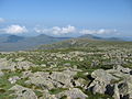 Northwest from Hamlin Peak
 Hamlin Peak
 Baxter Peak from Hamlin Peak
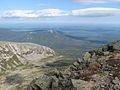 North Basin from Hamlin Peak


See also
- List of mountains in Maine
References
- "Hamlin Peak, Maine". Peakbagger.com.
- "Hamlin Peak". Geographic Names Information System. United States Geological Survey.
- "Hamlin Peak". SummitPost.org.
- "Mount Katahdin, ME". High-Powered Planet. Retrieved 2012-05-06.
- Hamlin Peak on TopoQuest
This Maine state location article is a stub. You can help Wikipedia by expanding it. |
Другой контент может иметь иную лицензию. Перед использованием материалов сайта WikiSort.org внимательно изучите правила лицензирования конкретных элементов наполнения сайта.
WikiSort.org - проект по пересортировке и дополнению контента Википедии