geo.wikisort.org - Mountains
Pigeon Mountain is a 2,394-metre (7,854-foot) mountain summit located in the Bow River Valley of Kananaskis Country in the Canadian Rockies of Alberta, Canada. Its parent peak is Skogan Peak, 5.0 km (3.1 mi) to the southeast.[2] Pigeon Mountain can be seen from Highway 1, the Trans-Canada Highway in the Canmore to Exshaw area.
| Pigeon Mountain | |
|---|---|
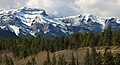
 Pigeon Mountain seen from Bow River | |
| Highest point | |
| Elevation | 2,394 m (7,854 ft)[1][2] |
| Prominence | 393 m (1,289 ft)[1] |
| Parent peak | Skogan Peak (2662 m)[2] |
| Listing | Mountains of Alberta |
| Coordinates | 51°01′42″N 115°12′24″W[3] |
| Geography | |
Pigeon Mountain Location of Pigeon Mountain in Alberta  Pigeon Mountain Pigeon Mountain (Canada) | |
| Location | Alberta, Canada |
| Parent range | Kananaskis Range[1] Canadian Rockies |
| Topo map | NTS 82O3 Canmore[3] |
| Geology | |
| Age of rock | Cambrian |
| Climbing | |
| Easiest route | Hiking[4] |
History
This mountain was named Pic de Pigeons in 1858 by Eugene Bourgeau, the French-born botanist while on the Palliser expedition, for flocks of pigeons seen near the mountain.[5] Since pigeons are a species that has been introduced and would not have been present in the Bow Valley in 1858, it is unclear what species of bird Bourgeau observed. The mountain's name was officially adopted in 1956 by the Geographical Names Board of Canada.[3]
Geology
Pigeon Mountain is composed of sedimentary rock laid down during the Precambrian to Jurassic periods.[6] Formed in shallow seas, this sedimentary rock was pushed east and over the top of younger rock during the Laramide orogeny.[7]
Climate
Based on the Köppen climate classification, Pigeon Mountain is located in a subarctic climate with cold, snowy winters, and mild summers.[8] Temperatures can drop below −20 °C with wind chill factors below −30 °C. Precipitation runoff from Pigeon Mountain drains into the Bow River which is a tributary of the Saskatchewan River.
Climbing
Pigeon Mountain is a hike mostly through meadows from its west side. An unofficial 2.8 kilometre trail gains 535 metres from the Skogan Pass Trail.[4] An exceptional view awaits from the summit.
Gallery
 Mount McGillivray (left) and Pigeon Mountain (right)
 Pigeon Mountain


See also
- List of mountains of Canada
- Geography of Alberta
References
- "Pigeon Mountain, Alberta". Peakbagger.com. Retrieved 2019-09-20.
- "Pigeon Mountain". Bivouac.com. Retrieved 2018-12-26.
- "Pigeon Mountain". Geographical Names Data Base. Natural Resources Canada. Retrieved 2018-12-26.
- Gillean Daffern's Kananaskis Country Trail Guide, Gillean Daffern, Volume 3, 4th Edition, Rocky Mountain Books, 2013, page 193.
- "Pigeon Mountain". PeakFinder.com. Retrieved 2019-09-20.
- Belyea, Helen R. (1960). The Story of the Mountains in Banff National Park (PDF). parkscanadahistory.com (Report). Ottawa: Geological Survey of Canada. Archived (PDF) from the original on 2015-10-02. Retrieved 2019-09-13.
- Gadd, Ben (2008). Geology of the Rocky Mountains and Columbias.
- Peel, M. C.; Finlayson, B. L.; McMahon, T. A. (2007). "Updated world map of the Köppen−Geiger climate classification". Hydrol. Earth Syst. Sci. 11: 1633–1644. ISSN 1027-5606.
External links
- Pigeon Mountain weather: Mountain Forecast
- Climbing Pigeon Mountain: Explor8ion.com
Places adjacent to Pigeon Mountain (Alberta) | ||||||||||||||||
|---|---|---|---|---|---|---|---|---|---|---|---|---|---|---|---|---|
| ||||||||||||||||
Другой контент может иметь иную лицензию. Перед использованием материалов сайта WikiSort.org внимательно изучите правила лицензирования конкретных элементов наполнения сайта.
WikiSort.org - проект по пересортировке и дополнению контента Википедии