geo.wikisort.org - Mountains
The North Palatine Uplands (German: Nordpfälzer Bergland), sometimes shortened to Palatine Uplands (Pfälzer Bergland), is a low mountain range and landscape unit in the German state of Rhineland-Palatinate and belongs mainly to the Palatinate region. It is part of the Saar-Nahe Uplands.
| North Palatine Uplands | |
|---|---|
 The North Palatine Uplands around Münchweiler in Donnersbergkreis
| |
| Highest point | |
| Peak | Donnersberg |
| Elevation | 686.5 m (2,252 ft) |
| Dimensions | |
| Length | 70 km (43 mi) |
| Geography | |
| State | Rhineland-Palatinate, Saarland |
| Range coordinates | 49°35′0″N 7°40′0″E |
| Parent range | North French Scarplands |
| Geology | |
| Orogeny | low mountains |
Geography
Location
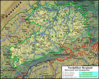
The North Palatine Uplands lie – roughly stated – between St. Wendel in the state of Saarland to the west and three towns belonging to Rhineland-Palatinate: Alzey to the east, Kaiserslautern to the south and Bad Kreuznach to the north, although these towns are not actually within the region itself. The North Palatine Uplands thus links the landscapes of the Palatine Forest, Saar-Hunsrück Nature Park, Naheland and Rheinhessen.
To the northwest its boundary with Naheland is not always clear. A rough guide is the heavily folded ridge north of the Glan river with a height different of as much as 300 metres in place.
The North Palatine Uplands fall mainly within the districts of Kusel and Donnersbergkreis. To a lesser extent it also falls within parts of Kaiserslautern, St. Wendel, Birkenfeld and Bad Kreuznach.
Hills

The North Palatine Uplands is characterised by numerous mountains, hills and valleys which lend the area sharp variations in height from about 200 to over 600 m above sea level (NN). The highest point is the Donnersberg which, at 687 m is also the highest mountain in the Palatinate. The following is a list of prominent mountains and hills in the Uplands, sorted by height in metres above sea level (NHN):
- Donnersberg (686.5 m)[1]
- Trautzberg (603.9 m)[2]
- Füsselberg (595.1 m)[2]
- Weiselberg (569.5 m)[2]
- Königsberg (568.2 m)[3]
- Potzberg (562 m)[3]
- Selberg (545.1 m)[3]
- Herrmannsberg (536.4 m)[3]
- Bornberg (520.0 m)[3]
Rivers

Important rivers in the west and north of the range are the 90 km long Glan and the 57 km long Alsenz. The 116 km long Nahe, into which the other two discharge, is no longer included in this region. The area of the Donnersberg is drained towards the east by the 43 km long Pfrimm, which itself rises in the northern Palatine Forest, and the 61 km long Selz. Both flow into the Upper Rhine.
Name
The North Palatine Uplands is also referred to locally as the "Old World" (German: alte Welt or in Palatinate German: die alt Welt or bucklige Welt).[4] However, sometimes the term alte Welt just refers to a strip of land on the border of the districts of Kusel and Kaiserslautern, which is roughly demarcated by the 420, 270 and 48 federal highways and the A 6 and A 63 motorways. Depending on how the region is defined, its largest village is either Nußbach or Obermoschel.
Settlement

The region is very rural in character and has no towns with more than 10,000 inhabitants. Important places are the county towns of Kirchheimbolanden and Kusel, and the collective municipalities of Alsenz, Altenglan, Lauterecken, Meisenheim, Rockenhausen, Winnweiler and Wolfstein.
Transportation
Roads
Motorways
- A 6 (Saarbrücken–Mannheim)
- A 62 (Landstuhl–Nonnweiler)
- A 63 (Kaiserslautern–Mainz)
Federal roads
- B 40 (Kaiserslautern–Alzey)
- B 48 (Winnweiler–Bad Kreuznach)
- B 270 (Kaiserslautern–Lauterecken)
- B 420 (Ottweiler–Bad Kreuznach)
- B 423 (Waldmohr–Altenglan)
Railways
- Glan Valley Railway
- Lauter Valley Railway
- Alsenz Valley Railway
- Zeller Valley Railway
- Donnersberg Railway
External links
References
- Inscription on the granite rock of the trig point on the Donnersberg rock formation of Königsstuhl
- Map services of the Federal Agency for Nature Conservation
- Map service of the Landscape Information System of the Rhineland-Palatinate Nature Conservation Office (Naturschutzverwaltung Rheinland-Pfalz)
- Verlag Eugen Ulmer: Die Pfalz ist eine Reise wert

Authority control | |
|---|---|
| General |
|
| National libraries | |
На других языках
[de] Nordpfälzer Bergland
Das Nordpfälzer Bergland, unkorrekt verkürzt auch nur Pfälzer Bergland, ist eine Mittelgebirgslandschaft im Süden von Rheinland-Pfalz und im Saarland. Der größte Teil der Fläche gehört zur Pfalz.- [en] North Palatine Uplands
Другой контент может иметь иную лицензию. Перед использованием материалов сайта WikiSort.org внимательно изучите правила лицензирования конкретных элементов наполнения сайта.
WikiSort.org - проект по пересортировке и дополнению контента Википедии