geo.wikisort.org - Mountains
The Kyffhäuser (German pronunciation: [ˈkɪfˌhɔɪ̯zɐ],[1] sometimes also referred to as Kyffhäusergebirge, is a hill range in Central Germany, shared by Thuringia and Saxony-Anhalt, southeast of the Harz mountains. It reaches its highest point at the Kulpenberg with an elevation of 473.4 metres (1,553 ft). The range is the site of medieval Kyffhausen Castle (Reichsburg Kyffhausen) and the 19th century Kyffhäuser Monument; it has significance in German traditional mythology as the legendary resting place of Emperor Frederick Barbarossa.
| Kyffhäuser | |
|---|---|
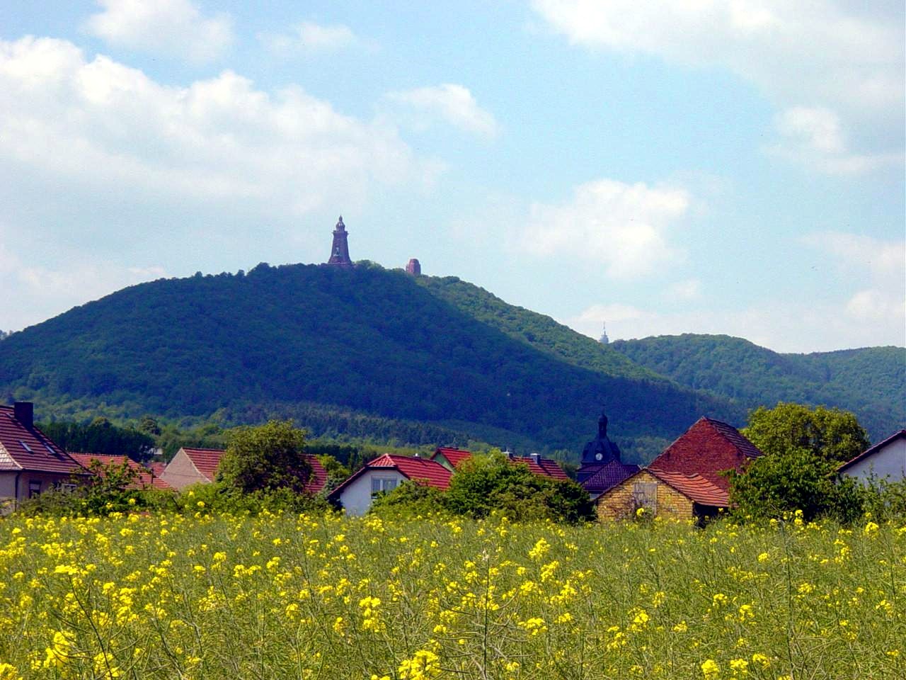 View from Tilleda of the hills and the Kyffhäuser Monument | |
| Highest point | |
| Peak | Kulpenberg |
| Elevation | 1,553 ft (473 m) |
| Geography | |
| Country | Germany |
| States | Thuringia and Saxony-Anhalt |
| Geology | |
| Orogeny | Variscan |
| Type of rock | Sandstone, Conglomerate, Carboniferous sedimentary and metamorphic rocks |
Etymology
The origin of the name has not been conclusively established. Kyffhäuser (formerly also Kiffhäuser) probably stems from the Low German word cuf, meaning "head" or "peak", and huse, "house". Other explanations refer to kiff, "quarrel" and the historic castles at the site.
Geography
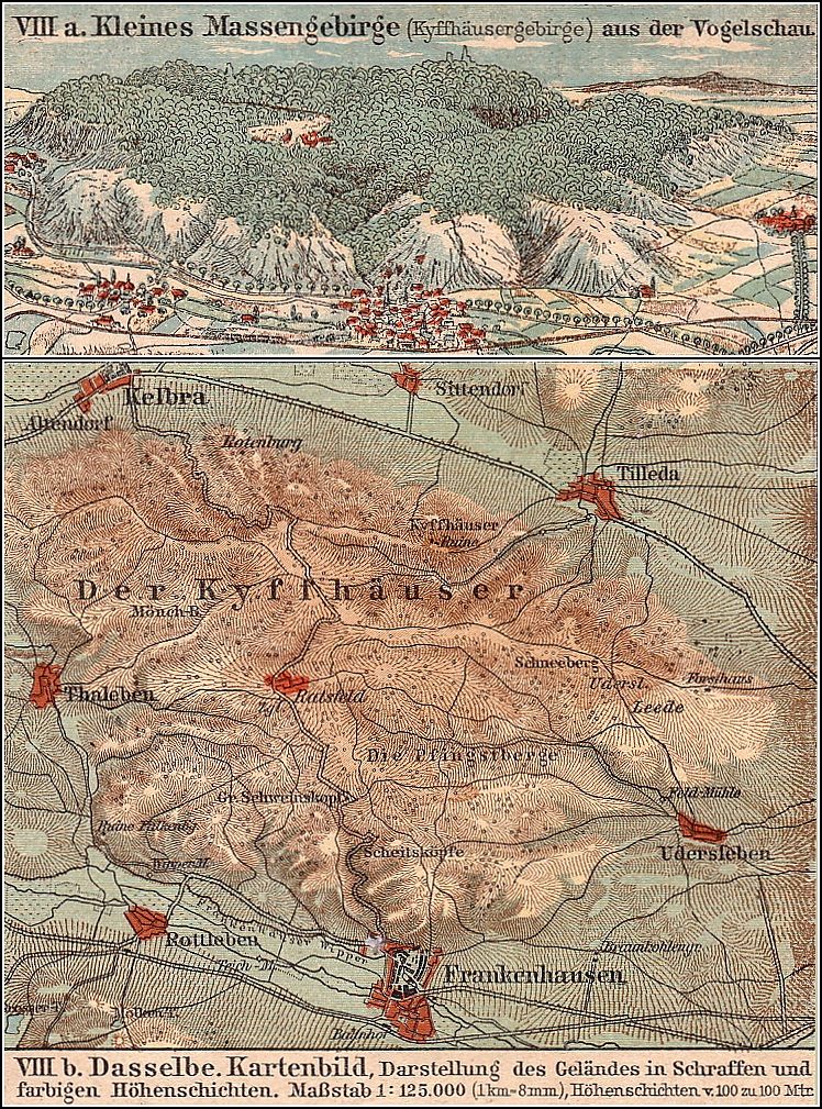
The Kyffhäuser is a small Mittelgebirge located in the Kyffhäuserkreis district of Thuringia and the Mansfeld-Südharz district of Saxony-Anhalt, not far from the larger Harz range to the northwest. The range has a length of 19 kilometres (12 mi), from west to east, and a width of 7 kilometres (4.3 mi).[2]: 124 The highest point at the Kulpenberg, with the Kulpenburg TV tower, is located near the village of Steinthaleben in Thuringia. The range borders on the Hainleite hill chain and the fertile Goldene Aue basin in the south. Large portions are protected as a nature park.
Some parts of the range on the western and southern slopes are karstified and bare of trees, covered by calcareous grassland.[2]: 124 The area shaped by numerous sandstone quarries today is the site of a geopark, comprising the Kyffhäuser Monument, the Barbarossa Cave near Rottleben, the Kaiserpfalz at Tilleda, and the Bilzingsleben Paleolithic site. The Schlachtberg hill on the southeastern rim near Bad Frankenhausen was the site of the decisive Battle of Frankenhausen during the German Peasants' War in 1525, commemorated in the monumental Early Bourgeois Revolution in Germany by Werner Tübke.
History
The settlement of Tilleda, located below the northern rim of the range, was already mentioned as Dullide in the early 9th century in the Breviarium Sancti Lulli register of Hersfeld Abbey. A Kaiserpfalz at the site is attested by the 972 Marriage Charter of Empress Theophanu.[3]: 13–15 Numerous stays of her husband Otto II, as well as by his successors Otto III, Conrad II, and Henry III are documented by deeds they issued here.
During the 11th century, Tilleda was superseded by a castle on the hill above the settlement that may have been erected by Emperor Henry IV during the Saxon Rebellion. His son Henry V inherited the quarrels and the castle was finally slighted by the Saxon Duke (and later Emperor) Lothair of Supplinburg in 1119. Lothair himself started the reconstruction in his later years and the Imperial Castle of Kyffhausen, one of the largest castle complexes in Germany, was completed under the Hohenstaufen emperor Frederick Barbarossa. Tilleda was last mentioned as an Imperial castle in 1194, when Frederick's son Henry VI reconciled here with the insurgent Welf duke Henry the Lion.
In 1698 Count Albert Anton of Schwarzburg-Rudolstadt had a Baroque hunting lodge erected at the hamlet of Rathsfeld in the centre of the Kyffhäuser range. Last used as a residence by Prince Günther Victor of Schwarzburg after his abdication in 1918, it was turned into a recreation home of the Kyffhäuserbund veterans' association in 1925. After World War II the remote site became a Young Pioneer camp and a training camp of the East German Gesellschaft für Sport und Technik; since German reunification, the empty premises have decayed.
Kyffhäuser legend

According to a king asleep in mountain legend, Emperor Frederick Barbarossa, who actually drowned on 10 June 1190 in the Calycadnus River near Seleukeia in Asia Minor during the Third Crusade, is not in fact dead, but sleeps in a hidden chamber underneath the Kyffhäuser hills. He sits motionless at a stone table and his beard has supposedly grown so long over the centuries that it grew through the table. As in the similar legend of King Arthur, Barbarossa supposedly awaits Germany's hour of greatest need, when he will emerge once again from under the hill. The presence of ravens circling the Kyffhäuser summit is said to be a sign of Barbarossa's continuing presence. Similar rapture legends refer to Emperor Frederick II or to Charlemagne sleeping in the Untersberg near Salzburg.
The Barbarossa myth was first documented in the late 17th century and later popularized by the Brothers Grimm and a poem written in 1817 by Friedrich Rückert. Frequently taken up by Romantic authors, and satirized in Germany. A Winter's Tale by Heinrich Heine, it became the expression of the desire for the Old Empire's re-emergence as a German nation state. When the Kyffhäuser Monument was built at the ruins of the Imperial Castle in 1890–1896, with a statue of Frederick Barbarossa and an Emperor William monument, the German Emperor William I was thought to have "laid to rest" Barbarossa by the 1871 unification of Germany.
The true background of the Kyffhäuser legend might be found in a cave on that mountain, in which important human remains were found. Some 130 persons seem to have been sacrificed to a female goddess in Bronze to Iron age times. Traces of cannibalism were found. This sacrifice to the goddess in the mountain (as well as in lakes and swamps) might be connected to the veneration of goddess Freia, Hulda or Dame Holle in the region. It could also be connected to the Venusberg of Wagner's Tannhäuser, set in the same area. The cave can be seen on the hill side, but is not accessible, due to a grate protecting it.
Today
Today, the hills are a popular tourist site, featuring the restored medieval Reichsburg Kyffhausen complex, including a small museum and the castle well, at 176 m (577 ft) depth said to be "the deepest castle well in the world".[2]: 126–127 The downhill Pfalz of Tilleda is an archaeological open-air museum and a stop on the scenic Romanesque Road.
The range is also the site of an annual touring car hillclimbing and of the Kyffhäuser-Berglauf cross country running competition. The range is a popular destination for hikers; the Kaiser Way leads across the Kyffhäuser northwards to the Harz mountains.
See also
- List of mountains and hills of Thuringia
- Sebastianism
References
- Duden - Das Aussprachewörterbuch, 7. Auflage (German), Dudenverlag, ISBN 978-3-411-04067-4
- Stahn, Dina (2009). Thüringen (German). Karl Baedeker Verlag. ISBN 978-3-8297-1175-3.
- Eberhardt, Hans; Grimm, Paul (2001). Die Pfalz Tilleda am Kyffhäuser, 6. Auflage (German). Gemeinde Tilleda. ISBN 3-910010-61-X.
- Sven Frotscher: Der Kyffhäuser – Natur, Geschichte, Architektur, Denkmale Europas. Artern 1996, ISBN 3-00-000509-9
External links
- Kyffhäuser Monument at the official Thuringia tourism website
- The true background of the Kyffhäuser legend

Authority control | |
|---|---|
| General | |
| National libraries | |
На других языках
[de] Kyffhäuser
Der Kyffhäuser (.mw-parser-output .IPA a{text-decoration:none}ˈkɪfˌhɔɪ̯zɐ[1] , seltener und historisch auch Kyffhäusergebirge genannt) ist ein kleines Mittelgebirge südlich des Harzes. Es ist ein Pultschollengebirge aus paläozoischen Gesteinen, welches sich steil nach Norden, aber nur sanft nach Süden hin abflacht, und dort im Süden und auch Westen vom Zechstein (Gipskarst) überlagert ist.[2] Es liegt größtenteils im Thüringer Kyffhäuserkreis und reicht am Nordrand geringfügig in den sachsen-anhaltischen Landkreis Mansfeld-Südharz hinein. Der Kyffhäuser ist bis zu 473,6 m ü. NHN[3] hoch und erstreckt sich über rund 70 km². Aufgrund seiner Nähe und wegen einiger geologischer Gemeinsamkeiten wird der Kyffhäuser auch „kleiner Bruder des Harzes“ genannt.- [en] Kyffhäuser
[fr] Kyffhäuser
Le Kyffhäuser est un massif de moyenne montagne escarpé situé en Allemagne centrale, au sud-est du Harz, sur la limite entre les Länder de Thuringe et de Saxe-Anhalt.[ru] Кифхойзер
Кифхойзер, или Кюфхёйзер (нем. Kyffhäuser) — небольшой по протяжённости покрытый лесом горный массив, являющийся частью Среднегерманской горной системы и находящийся к юго-востоку от Гарца. Горный массив расположен между долинами Хельме и Унструта. Наивысшей точкой массива является Кульпенберг, высотой 473,6 м с установленной на ней 94-метровой телевизионной мачтой.Другой контент может иметь иную лицензию. Перед использованием материалов сайта WikiSort.org внимательно изучите правила лицензирования конкретных элементов наполнения сайта.
WikiSort.org - проект по пересортировке и дополнению контента Википедии