geo.wikisort.org - Mountains
Mount Tyrwhitt is a mountain in British Columbia and Alberta, Canada located between Highway 40 and Elk Pass in the Elk Range of the Canadian Rockies, west of the Highwood Pass parking lot in Kananaskis Country and south east of Upper Kananaskis Lake. Located on the Continental Divide, it is also therefore on the border between British Columbia and Alberta which follows the Divide in this area.
| Mount Tyrwhitt | |
|---|---|
 Mount Tyrwhitt's north face with Grizzly col to the left | |
| Highest point | |
| Elevation | 2,874 m (9,429 ft)[1][2][3] |
| Prominence | 216 m (709 ft)[4] |
| Parent peak | Mount Pocaterra (2941 m)[4] |
| Listing | |
| Coordinates | 50°34′57″N 115°00′58″W[5] |
| Geography | |
 Mount Tyrwhitt Location in eastern British Columbia | |
| Country | Canada |
| Provinces | Alberta and British Columbia |
| Parent range | Elk Range |
| Topo map | NTS 82J11 Kananaskis Lakes[5] |
| Climbing | |
| First ascent | 1915 by the Interprovincial Boundary Commission[4] |
| Easiest route | Scramble (Moderate)[3] |
The mountain was named in 1918 after First Admiral Reginald Tyrwhitt, a senior officer in the Royal Navy during the First World War.[5]
Gallery
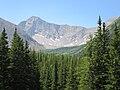 Mount Tyrwhitt from Kananaskis Trail

See also
- List of peaks on the Alberta–British Columbia border
References
- Kananaskis Lakes (Map). 1:50,000. Cochrane, AB: Gem Trek Publishing. 1998. § D5. ISBN 1-895526-24-8. Retrieved 2021-07-16.
- "Mount Tyrwhitt". PeakFinder.com. Retrieved 2019-08-20.
- Kane, Alan (2016). "Mount Tyrwhitt". Scrambles in the Canadian Rockies (3rd ed.). Calgary: Rocky Mountain Books. Kindle Edition. ISBN 978-1-77160-098-9.
- "Mount Tyrwhitt". Bivouac.com. Retrieved 2009-01-02.
- "Mount Tyrwhitt". BC Geographical Names. Retrieved 2013-06-12.
External links
- "Mount Tyrwhitt". Peakware.com. Archived from the original on 2016-03-04.
This Alberta location article is a stub. You can help Wikipedia by expanding it. |
This article about a location in the Interior of British Columbia, Canada is a stub. You can help Wikipedia by expanding it. |
Текст в блоке "Читать" взят с сайта "Википедия" и доступен по лицензии Creative Commons Attribution-ShareAlike; в отдельных случаях могут действовать дополнительные условия.
Другой контент может иметь иную лицензию. Перед использованием материалов сайта WikiSort.org внимательно изучите правила лицензирования конкретных элементов наполнения сайта.
Другой контент может иметь иную лицензию. Перед использованием материалов сайта WikiSort.org внимательно изучите правила лицензирования конкретных элементов наполнения сайта.
2019-2026
WikiSort.org - проект по пересортировке и дополнению контента Википедии
WikiSort.org - проект по пересортировке и дополнению контента Википедии