geo.wikisort.org - Mountains
The Mount Royal Range is a mountain range in the Hunter region of New South Wales, Australia.
| Mount Royal | |
|---|---|
 | |
| Highest point | |
| Peak | Brumlow Tops |
| Elevation | 1,586 m (5,203 ft) |
| Dimensions | |
| Length | 95 km (59 mi) S |
| Geography | |
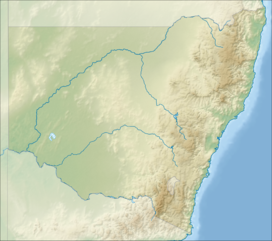 Location of the range in New South Wales. | |
| Country | Australia |
| State | New South Wales |
| Region | Hunter |
| Range coordinates | 31°50′S 151°29′E |
| Parent range | Great Dividing Range |
Location and features
The Mount Royal Range is a spur on the eastern side of the Great Dividing Range. It diverges from the Liverpool Range at a point north of Scone, New South Wales, near Ben Halls Gap. The range generally extends to the southeast for about 45 kilometres (28 mi) and then generally to the south southwest for about 50 kilometres (31 mi) to Mount Royal.[1] The range generally forms the divide between the Hunter River and Manning River drainage basins, both of which drain to the Tasman Sea.
The range contains a number of prominent peaks including:[2]
- Brumlow Tops with an elevation of 1,586 metres (5,203 ft) AHD
- Mount Polblue with an elevation of 1,575 metres (5,167 ft) AHD [3]
- Mount Barrington with an elevation of 1,555 metres (5,102 ft) AHD
- Mount Royal with an elevation of 1,185 metres (3,888 ft) AHD
- Mount Allyn with an elevation of 1,125 metres (3,691 ft) AHD
- Prospero with an elevation of 1,189 metres (3,901 ft) AHD
- Gulph Mountain
- Gog and Magog
- The Pinnacle
- Paddys Ridge
- Mount William
- Mount Paterson
- Mount Toonumbue
- the Belgrave Pinnacle
- Mirannie Mountain
- Mount George
- Hudsons Peak
- Mount Johnstone
Etymology
The range is named after Mount Royal, one of its prominent peaks.
Water storage
To provide water for the Bayswater Power Station, the Barnard River Scheme was constructed in the 1980s so water could be transported over the range into the Hunter River.
Geology
The Mount Royal range forms the northern rim of the Hunter Region. The Barrington Tops, an elevated plateau at the headwaters of the Barrington River, are part of the Mount Royal Range. The World Heritage listed Barrington Tops National Park includes this area.
Gallery
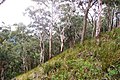 Mount Royal - eucalyptus forest
 Mount Royal - eucalyptus forest
 Mount Royal, basalt at 1100 metres
 Mount Royal - cloud forest, moss & ferns
 Mount Royal - cloud forest, basalt & ferns
 Mount Royal, cloud forest, basalt, ferns & moss
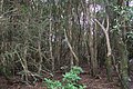 Mount Royal, cloud forest, Hill water gum rainforest at summit
 Snow Gums at Brumlow Tops summit, elevation 1586 metres, the highest point in northern New South Wales


See also
- List of mountains of Australia
References
- "Mount Royal Range". Geographical Names Register (GNR) of NSW. Geographical Names Board of New South Wales. Retrieved 19 October 2013.
- "Mountain systems of Australia". Australian Bureau of Statistics:Year Book Australia, 1909. Retrieved 4 February 2008.
- "Barrington Tops World Heritage Area". Archived from the original on 5 September 2008. Retrieved 4 February 2008.
На других языках
[de] Mount Royal Range
Die Mount Royal Range ist ein Bergland in New South Wales, Australien, ein Gebiet in der Hunter-River-Region, etwa 90 km von Newcastle entfernt.- [en] Mount Royal Range
[es] Cadena del Monte Royal
La cordillera del Monte Royal (en inglés, Mount Royal Range) es una cordillera en Nueva Gales del Sur, Australia. Picos prominentes en la cadena incluyen el monte Polblue (1575 m),[1] Cumbres Brumlow (Brumlow Tops, 1586 m), montaña Gulph (Gulph Mountain), Gog y Magog, El Pináculo (The Pinnacle), Cresta de Paddy (Paddy's Ridge), monte William, monte Paterson, Monte Allyn, monte Royal (1185 m), monte Toonumbue, el pináculo Belgrave (Belgrave Pinnacle), montaña Mirannie (Mirannie Mountain), monte George (Mount George), pico de Hudson (Hudson's Peak), monte Johnstone.[2] La cordillera fue nombrada por el monte Royal (Mount Royal), uno de sus picos prominentes.Другой контент может иметь иную лицензию. Перед использованием материалов сайта WikiSort.org внимательно изучите правила лицензирования конкретных элементов наполнения сайта.
WikiSort.org - проект по пересортировке и дополнению контента Википедии