geo.wikisort.org - Island
Kooragang (/ˈkuːrəɡæŋ/)[7] is the northernmost and largest suburb of the city of Newcastle, in the Hunter Region of New South Wales, Australia.[2] Dominated by Kooragang Island, the eastern part of the suburb is primarily industrial, while the western part of the suburb consists of nature reserves.[8] Covering an area of 35.4 km2 (13.7 sq mi), at the 2016 census, there were no people living in the suburb.[1]
| Kooragang Newcastle, New South Wales | |||||||||||||||
|---|---|---|---|---|---|---|---|---|---|---|---|---|---|---|---|
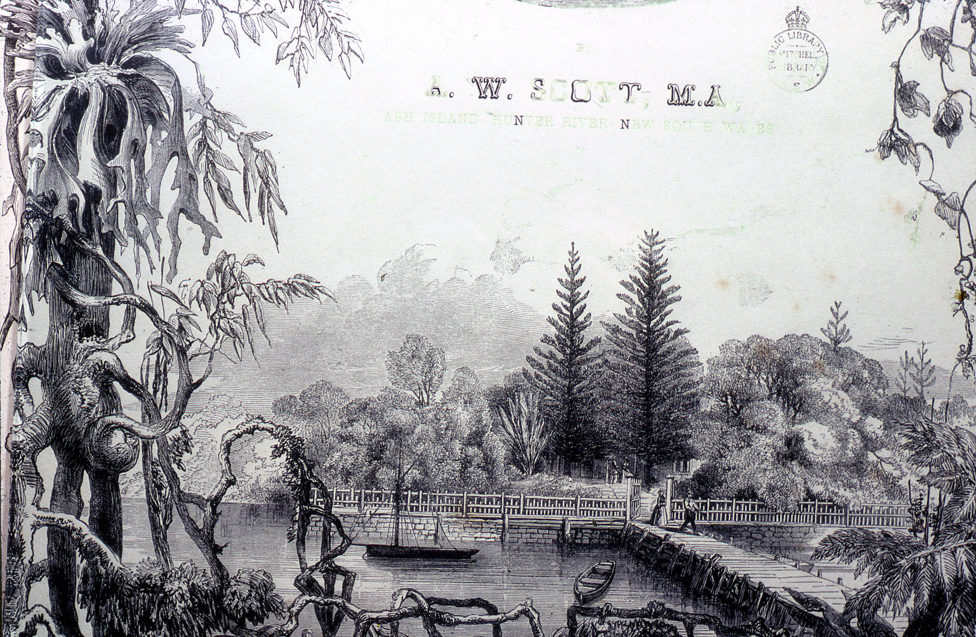 The former Alexander Walker Scott's Estate on Ash Island | |||||||||||||||
Kooragang | |||||||||||||||
| Coordinates | 32°52′34″S 151°46′4″E | ||||||||||||||
| Population | 0 (2016 census)[1] | ||||||||||||||
| • Density | 0.000/km2 (0.00/sq mi) | ||||||||||||||
| Postcode(s) | 2304 | ||||||||||||||
| Elevation | 3 m (10 ft)[Note 1] | ||||||||||||||
| Area | 35.4 km2 (13.7 sq mi)[Note 2] | ||||||||||||||
| Time zone | AEST (UTC+10) | ||||||||||||||
| • Summer (DST) | AEDT (UTC+11) | ||||||||||||||
| Location |
| ||||||||||||||
| LGA(s) | City of Newcastle[2] | ||||||||||||||
| Region | Hunter[2] | ||||||||||||||
| County | Northumberland[3] | ||||||||||||||
| Parish | Newcastle[3] | ||||||||||||||
| State electorate(s) | Newcastle[4] | ||||||||||||||
| Federal division(s) | Newcastle[5] | ||||||||||||||
| |||||||||||||||
| |||||||||||||||
Geography
Kooragang extends from Stockton in the southeast, to the eastern bridge at Hexham[Note 3] in the northwest, a distance of 12.4 km (7.7 mi). Except for a small portion of land in Hexham, the north and south arms of the Hunter River forms Kooragang's borders. At its greatest, the suburb is approximately 3.8 km (2.4 mi) from southwest – northeast. Vehicular access to Kooragang is via three bridges. From Mayfield West the Tourle Street Bridge is the primary access to Kooragang, Stockton and Port Stephens from Newcastle suburbs. In the east of the suburb, the Stockton Bridge connects Kooragang to Stockton. Access to the western part of the suburb is via the Ash Island bridge at Hexham.[8]
Kooragang is generally low and flat, with some build-up in the industrial area in the eastern part of the suburb, on Kooragang Island.[8]
History
Kooragang is dominated by Kooragang Island, which was created by reclaiming land, combining a number of smaller islands in the Hunter River estuary.[9] The original islands were separated by mud flats and various channels and were first explored and surveyed by Europeans in 1801.[9] Larger islands included Ash Island, Upper Moscheto, Moscheto Island, Dempsey Island, and Spit Island.[10]
Ash Island was the largest of the islands, named because of the Ash trees that grew upon it. By 1821, much of Ash and other timber on the island had been harvested. In 1827 Alexander Scott was granted 1,036 ha (2,560 acres) of land there. After settling on the island in 1831, it grew as a community with many visitors. The original wooden bridge linking the island to the mainland was eventually replaced with a concrete bridge that is still used today. Fifty families lived on the island until it was devastated by the 1955 Hunter Valley floods. By the 1960s, industrial development closer to Newcastle resulted in a land reclamation scheme that combined the smaller islands into what is now Kooragang Island. The western part of Kooragang island, which is now home to the Kooragang Wetland Rehabilitation Project, is still known as Ash Island.[9]
Kooragang Island
Coal exports
The eastern and more well-known part of Kooragang Island is primarily a coal export port.[11] It was established in 1984 by a BHP led consortium, with a capacity of 15 million tonnes per annum.[12][13] By 2013 the capacity had been increased to 120 million tonnes per annum.[13] In July 2013 a record high of 10.3 million tonnes of coal was processed through the port of Newcastle, with 83 of the 114 ships being loaded at the Kooragang terminal.[14]
Transport of coal to Kooragang Island from Hunter valley coal mines is achieved via the Sandgate Flyover, with coal trains being moved through the port by a balloon loop.
Other industries
In addition to coal exports, many other industries exist on Kooragang Island, some having existed there since before the coal export port was established. Industries include Mountain Industries, which operates a bitumen plant, Blue Circle Southern Cement, Sims Metal recyclers and Orica Kooragang, which manufactures agricultural fertiliser and explosives for the mining industry. Orica Kooragang opened in 1969.[15]
Electricity generation
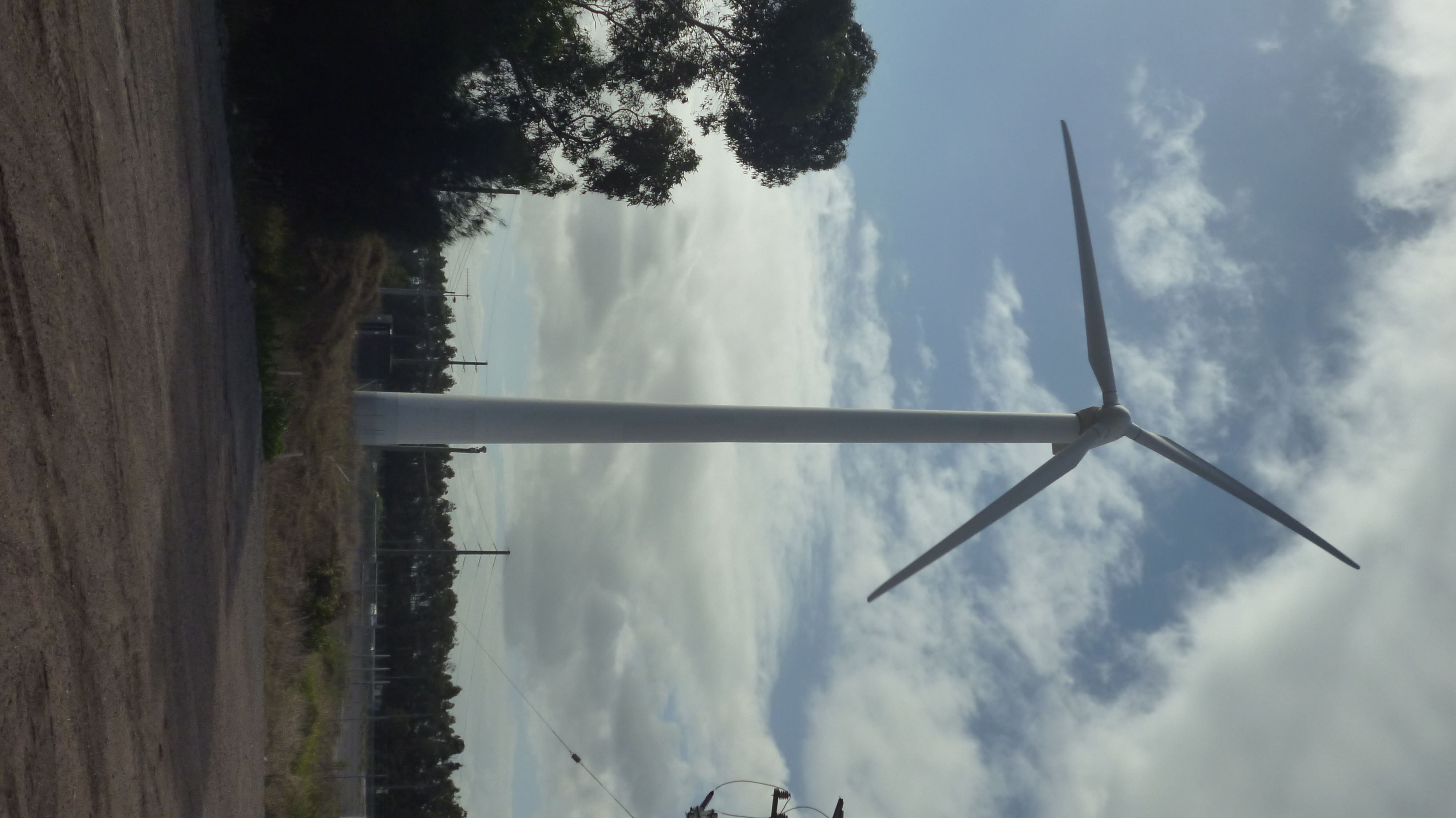
A single 600 kW wind turbine was installed on the island between Cormorant Road and the Hunter River in 1997, generating enough power for 150 homes per year.[16][17] However, its future came into question because it sat on land that may be needed for a future ship turning basin.[17] It was eventually dismantled on 29 October 2014.[18][19] The turbine was later installed in Tasmania.[20]
Ash Island
Ash Island is 12 km (7 mi) west of the Newcastle CBD and covers an area of 780 ha (1,927 acres).[21] It is accessed by a road bridge at the western end of the island. Originally, a wooden bridge was constructed to connected Ash Island from Hexham and a jetty was constructed near the Scott house.[22] After concerns about the environmental impacts of industry the Coffey Inquiry was held in 1970 listing concerns over pollution and environmental degradation.[22] It has over 200 species of birds and 15 species of frogs.[21] There over 300 native plant species.[23] It has a combination of rainforest, mangroves and saltmarshes.[21] Europeans settlement introduced kikuyu grass to the area.[23]
History
The Indigenous mobs of the Worimi and Awabakal were the first used the area as major food source.[22] In 1797 Europeans discovered red cedar and ash trees.[23] In 1801 Captain William Paterson commissioned a survey.[24] In the 1800s industrial activity began on the island.[22] In the 1860s the land was transformed to agricultural land and dairy farms.[22] Ash Island has 17 dairy farms with 55 families living there.[23] In 1921 the bridge built by the A.A Company was demolished.[24] In 1955 all the families moved out due to major flooding.[22] After this the NSW government took control of the land and leased it for grazing land.[22] In the 1960s a large scale industrial development began and by 1968 become a part of Kooragang Island.[22] In 1968, a 10 klometre railway line opened on Kooragang Island, branching off the Main Northern railway line to the west of Warabrook station.[25] In 1984 the area was declared a Ramsar site, In 1983 Kooragang Nature Reserve was formed.[22] In 1993 Kooragang Wetlands Rehabilitation Project was founded.[22]
Notable people
In 1827 Alexander Walker Scott purchased 2,560 acres of land. In 1846 Scott moved his wife Harriet Calcott, step daughter Mary Ann and daughter Helena and Harriet from Sydney. Harriet Scott was 16 and her sister was 14 when they moved from Sydney to Ash Island.[26] They were both famous artists with majority of their letters is displayed at the Australian Museum.[26] In 1866 Scott became bankrupt and sold the property which was subdivided, cleared and drained.[22] In 2020 Dr Bernadette Drabsh from the University of Newcastle and natural history student Rachel Klyvee released a documentary series about a project wanting the restore the scott's sister image.[27]
Friedrich Wilhelm Ludwig Leichardt was a German born artist who visited the Hunter Region between 1842 and 1843.[28] He was invited by Alexander Walker Scott to travel down to Ash Island.[28] He arrived on Friday 23 September 1842 and spent 3–4 days on Ash Island.[28] Many of his sketches are held in the National Library of Australia and State Library of New South Wales.[28]
Conrad Marten was English artist who spent time on Charles Darwin's ship HMS Beagle.[29] He travelled around the Hunter area between 1841 and 1852 visiting Ash Island.[29] His drawings from the Hunter area are digitised in the State Library of New South Wales.[29]
Heritage listings
131 Radar Station, located on Ash Island, is a heritage-listed site.[30]
Notes
- Kooragang is primarily flat. The average elevation of the suburb is as shown on 1:100000 map 9232 NEWCASTLE.
- Area calculation is based on 1:100000 map 9232 NEWCASTLE.
- Although known as the "Hexham bridge", there are actually two bridges crossing the Hunter River. Both are in the suburb of Tarro with the north and south ends of the bridges in Tomago and Hexham respectively.
References
- Australian Bureau of Statistics (27 June 2017). "Kooragang (State Suburb)". 2016 Census QuickStats. Retrieved 6 July 2017.
- "Suburb Search – Local Council Boundaries – Hunter (HT) – Newcastle City Council". New South Wales Division of Local Government. Archived from the original on 26 March 2011. Retrieved 2 December 2013.
- "Kooragang". Geographical Names Register (GNR) of NSW. Geographical Names Board of New South Wales. Retrieved 2 December 2013.
- "Newcastle". New South Wales Electoral Commission. Retrieved 23 November 2019.
- "Newcastle". Australian Electoral Commission. Archived from the original on 21 May 2011. Retrieved 2 December 2013.
- "Newcastle Nobbys Signal Station AWS". Climate statistics for Australian locations. Bureau of Meteorology. Retrieved 2 December 2013.
- "Search By Letter – ABC PRONOUNCE". Australian Broadcasting Corporation. Archived from the original on 11 February 2017. Retrieved 10 February 2017.
- "Kooragang". Land and Property Management Authority - Spatial Information eXchange. New South Wales Land and Property Information. Retrieved 2 December 2013.
- Dorey, Fran (28 May 2012). "A history of Ash Island". australianmuseum.net.au. Australian Museum. Retrieved 2 December 2013.
- "Kooragang Island in 1871". coalriver.wordpress.com. Coal River Working Party. 7 February 2013. Retrieved 2 December 2013.
- "Kooragang Island". Newcastle City Council website. 11 October 2013. Archived from the original on 3 December 2013. Retrieved 2 December 2013.
- Kooragang coal terminal boosts Australia's exports Railway Gazette International November 1984 pages 865-867
- "Kooragang Coal Terminal". Port Waratah Coal Services. Archived from the original on 31 March 2012. Retrieved 2 December 2013.
- Carr, Matt (2 August 2013). "Coal exports at a record high". The Newcastle Herald. Retrieved 2 December 2013.
- "History – Orica Kooragang Island". orica.com. Retrieved 2 December 2013.
- "Renewable energy generation (EA owned/operated)". EnergyAustralia website. EnergyAustralia. Archived from the original on 10 February 2007. Retrieved 23 August 2009.
- Kelly, Matthew (30 May 2013). "Kooragang wind turbine future in spin". The Newcastle Herald. Retrieved 2 December 2013.
- McMahon, Jeannette (29 October 2014). "Our unwanted wind turbine snapped up by Tassie". ABC News. Retrieved 24 December 2014.
- Kelly, Matthew (28 October 2014). "Goodbye, Kooragang wind turbine". The Newcastle Herald. Retrieved 24 December 2014.
- Kelly, Margot (1 June 2016). "Kooragang Island turbine starts new life in Tasmania". ABC News. Retrieved 22 June 2016.
- "Visit". Schoolmasters House in Kooragang Wetlands. 24 September 2014. Retrieved 23 September 2020.
- Dorey, Fran (22 November 2018). "A history of Ash Island". The Australian Museum. Retrieved 23 September 2020.
- "History of the Hunter Estuary". Schoolmasters House in Kooragang Wetlands. 17 November 2014. Retrieved 23 September 2020.
- "Ash Island". Newcastle Morning Herald and Miners' Advocate. 24 May 1950. Retrieved 23 September 2020.
- Islands Development Area Branch Opened Railway Transportation March 1968 page 5
- Vial, Jodi (27 March 2017). "The Scott Sisters of Ash Island". Hunter Living Histories. Retrieved 23 September 2020.
- Dormand, Glenn (24 June 2020). ""Stories of Our Town" Newcastle Documentary Series – Scott Sister's of Ash Island". Hunter Living Histories. Retrieved 23 September 2020.
- "Ludwig Leichard in Newcastle". Hunter Living Histories. 29 January 2013. Retrieved 23 September 2020.
- "Conrad Martens in Newcastle and the Hunter". Hunter Living Histories. 23 January 2012. Retrieved 23 September 2020.
- "131 Radar Station (former)". New South Wales State Heritage Register. Office of Environment & Heritage. H01815. Retrieved 18 May 2018.
External links
![]() Media related to Kooragang, New South Wales at Wikimedia Commons
Media related to Kooragang, New South Wales at Wikimedia Commons
Другой контент может иметь иную лицензию. Перед использованием материалов сайта WikiSort.org внимательно изучите правила лицензирования конкретных элементов наполнения сайта.
WikiSort.org - проект по пересортировке и дополнению контента Википедии