geo.wikisort.org - Mountains
Mount Louis is a 2,682-metre (8,799-foot) mountain summit located in southeast Banff National Park in Alberta, Canada. It is part of the Sawback Range which is a subset of the Canadian Rockies.
| Mount Louis | |
|---|---|
 | |
| Highest point | |
| Elevation | 2,682 m (8,799 ft)[1] |
| Prominence | 336 m (1,102 ft)[2] |
| Parent peak | Mount Cory (2802 m)[2] |
| Listing | Mountains of Alberta |
| Coordinates | 51°12′54″N 115°40′48″W[2] |
| Geography | |
Mount Louis Location in Alberta | |
| Location | Alberta, Canada |
| Parent range | Sawback Range |
| Topo map | NTS 82O4 Banff |
| Geology | |
| Age of rock | Devonian |
| Mountain type | Limestone[2] |
| Climbing | |
| First ascent | 1916 by Conrad Kain and Albert H. McCarthy[1][3] |
| Easiest route | rock climb (YDS 5.6)[2] |
The mountain was named in 1886 after Louis B. Stewart who surveyed in the Banff Park area in 1904 with his father, George Stewart, the first Park Superintendent.[1][2]
Geology
Mount Louis is composed of limestone, a sedimentary rock laid down during the Devonian period.[4] Formed in shallow seas, this sedimentary rock was pushed east and over the top of younger rock during the Laramide orogeny.[5]
Climate
Based on the Köppen climate classification, Mount Louis is located in a subarctic climate zone with cold, snowy winters, and mild summers.[6] Temperatures can drop below -20 °C with wind chill factors below -30 °C. Weather conditions during summer months are optimum for climbing. Precipitation runoff from Mount Louis drains into the Bow River which is a tributary of the Saskatchewan River.
See also
- List of mountains of Canada
- Geology of Alberta
References
- "Mount Louis". PeakFinder.com. Retrieved 2019-08-28.
- "Mount Louis". Bivouac.com. Retrieved 2008-10-05.
- Thorington, J. Monroe (1966) [1921]. "Peaks in the Environs of Banff". A Climber's Guide to the Rocky Mountains of Canada. With the collaboration of Putnam, William Lowell (6th ed.). American Alpine Club. p. 75. ISBN 978-1376169003.
- Belyea, Helen R. (1960). The Story of the Mountains in Banff National Park (PDF). parkscanadahistory.com (Report). Ottawa: Geological Survey of Canada. Archived (PDF) from the original on 2015-10-02. Retrieved 2019-09-13.
- Gadd, Ben (2008). Geology of the Rocky Mountains and Columbias.
- Peel, M. C.; Finlayson, B. L.; McMahon, T. A. (2007). "Updated world map of the Köppen−Geiger climate classification". Hydrol. Earth Syst. Sci. 11: 1633–1644. ISSN 1027-5606.
External links
- National Park Service web site: Banff National Park
Gallery
 Mt. Louis
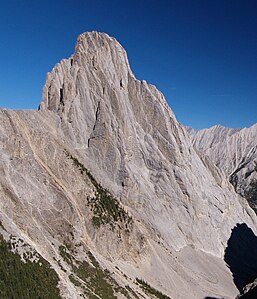 Mount Louis seen from Cory Pass
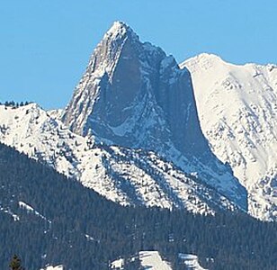 Mount Louis seen from Johnson Lake
 Telephoto of Mount Louis as seen from Sulphur Mountain


Другой контент может иметь иную лицензию. Перед использованием материалов сайта WikiSort.org внимательно изучите правила лицензирования конкретных элементов наполнения сайта.
WikiSort.org - проект по пересортировке и дополнению контента Википедии