geo.wikisort.org - Mountains
Mount Fryatt is Alberta's 26th highest peak. In 1920, it was named after Captain Charles Fryatt, a British merchant seaman who was executed by the Germans during World War I.[6] It lies within peaks that are between the Athabasca and Whirlpool Rivers in Jasper National Park.[1][3]
| Mount Fryatt | |
|---|---|
 | |
| Highest point | |
| Elevation | 3,361 m (11,027 ft)[1][2] |
| Prominence | 1,608 m (5,276 ft)[3][4] |
| Parent peak | Mount Edith Cavell[3] |
| Listing |
|
| Coordinates | 52°33′00″N 117°54′37″W[5] |
| Geography | |
Mount Fryatt Location of Mount Fryatt in Alberta  Mount Fryatt Mount Fryatt (Canada) | |
| Location | Alberta, Canada |
| Parent range | Canadian Rockies |
| Topo map | NTS 83C12 Athabasca Falls |
| Climbing | |
| First ascent | 1926 J. Hickson; H. Palmer; H. Fuhrer[3] |
| Easiest route | South-West Face (Normal Route) II 5.4 West Ridge Direct III 5.8[1] |
Geology
Mount Fryatt is composed of sedimentary rock laid down from the Precambrian to Jurassic periods.[7] Formed in shallow seas, this sedimentary rock was pushed east and over the top of younger rock during the Laramide orogeny.[8]
Climate
Based on the Köppen climate classification, Mount Fryatt is located in a subarctic climate with cold, snowy winters, and mild summers.[9] Temperatures can drop below -20 °C with wind chill factors below -30 °C. Precipitation runoff from Mount Fryatt drains into tributaries of the Athabasca River.
See also
- Geology of Alberta
- Brussels Peak
Gallery
 Mount Fryatt from Fryatt Valley
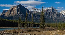 Mount Fryatt centered behind its outliers as seen from the Icefields Parkway


References
- "Mount Fryatt". PeakFinder.com. Retrieved 2019-08-16.
- "British Columbia and Alberta: The Ultra-Prominent Page". peaklist.org. Retrieved 2012-11-03.
- "Mount Fryatt". Bivouac.com. Retrieved 2012-11-03.
- "Mount Fryatt, Alberta". Peakbagger.com. Retrieved 2012-11-03.
- "Mount Fryatt". Geographical Names Data Base. Natural Resources Canada. Retrieved 2019-08-16.
- Place-names of Alberta. Ottawa: Geographic Board of Canada. 1928. p. 55.
- Belyea, Helen R. (1960). The Story of the Mountains in Banff National Park (PDF). parkscanadahistory.com (Report). Ottawa: Geological Survey of Canada. Archived (PDF) from the original on 2015-10-02. Retrieved 2019-09-13.
- Gadd, Ben (2008). Geology of the Rocky Mountains and Columbias.
- Peel, M. C.; Finlayson, B. L.; McMahon, T. A. (2007). "Updated world map of the Köppen−Geiger climate classification". Hydrol. Earth Syst. Sci. 11: 1633–1644. ISSN 1027-5606.
This Alberta's Rockies location article is a stub. You can help Wikipedia by expanding it. |
Другой контент может иметь иную лицензию. Перед использованием материалов сайта WikiSort.org внимательно изучите правила лицензирования конкретных элементов наполнения сайта.
WikiSort.org - проект по пересортировке и дополнению контента Википедии