geo.wikisort.org - Mountains
Mont Albert (English: Mount Albert) is a mountain in the Chic-Choc range in the Gaspésie National Park in the Gaspé Peninsula of eastern Quebec, Canada. At 1,151 m (3,776 ft),[1] it is one of the highest mountains in southern Quebec, and is popular for hiking.
| Mont Albert | |
|---|---|
 | |
| Highest point | |
| Elevation | 1,151 m (3,776 ft)[1] |
| Prominence | 740m[2] |
| Listing | Quebec 1000 meter peaks List of mountains in Canada |
| Coordinates | 48°55′17″N 66°11′42″W |
| Geography | |
 Mont Albert Location in Quebec | |
| Location | Mont-Albert, Quebec, Canada |
| Parent range | Chic-Choc Mountains |
| Topo map | NTS 22B16 Mont Albert |
| Climbing | |
| First ascent | August 26, 1845 by Alexander Murray |
Mount Albert was named in honour of Prince Albert of Saxe-Coburg and Gotha, husband of Queen Victoria, because geologist Alexander Murray made the first recorded ascent of the mountain on the Prince's birthday, 26 Aug. 1845.[1]
Geography

The summit of Mount Albert is a plateau 13 km (8.08 mi) across called La Table à Moïse, or Moses's Table.[3] It includes two summits, Albert North (1,070 m (3,510 ft))[4] and Albert South (1,151–1,154 m (3,776–3,786 ft)).[1][5] Each of the summits is situated at either side of the plateau.
The principal component of Mont Albert is an unusual kind of bedrock called serpentine; this originated as oceanic crust and was then uplifted during the formation of the Appalachian Mountains about 480 million years ago.[3] The nearly flat serpentine tableland on the mountain's summit is an alpine tundra area above the tree line, and supports a quite distinctive flora with many kinds of endemic and highly disjunct plants.[6]
The ascent of Mount Albert from near sea level is challenging, but popular with hikers, offering a view of the St. Lawrence and the Côte-Nord, the river's north shore, part of the ancient bedrock of the Canadian Shield.
Gallery
 Plateau at the summit of Mount Albert
 Grande Cuve of Mount Albert
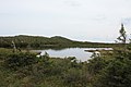 Lake on the plateau at the summit of Mount Albert
 Snowpack and waterfall, Grande Cuve, Mount Albert
 Shrubs on the plateau at the summit of Mount Albert
 Flora on Mount Albert
 Flora, Grande Cuve, Mount Albert
 Flora, Grande Cuve, Mount Albert


References
- Gouvernement du Québec (2011). "Mont Albert" (in French). Commission de toponymie. Retrieved 4 Jan 2011.
- "Mont Albert, Québec". Peakbagger.com. 1 Nov 2004. Retrieved 2 Sep 2011.
- Marie-José Auclair. "Un vaste plateau orangé: le mont Albert" (in French). Géoplein Air. Archived from the original on 4 May 2011. Retrieved 15 Aug 2011.
- "Sommet Albert Nord". Banque de noms de lieux du Québec (in French). Commission de toponymie. Retrieved 15 August 2011.
- "Sommet Albert Sud". Banque de noms de lieux du Québec (in French). Commission de toponymie. Retrieved 15 August 2011.
- Scoggan, H.J. (1950). The Flora of Bic and the Gaspé Peninsula, Quebec. Ottawa, Canada: National Museum of Canada. p. 399.
На других языках
[de] Mont Albert
Der Mont Albert ist ein Berg in den Monts Chic-Chocs, einer Gebirgskette, die den Appalachen zugeordnet wird, im Südosten der kanadischen Provinz Québec.- [en] Mount Albert (Quebec)
[fr] Mont Albert
Le mont Albert est une montagne des monts Chic-Chocs localisée dans le parc national de la Gaspésie dans la région de Gaspésie–Îles-de-la-Madeleine au Québec au Canada. Il atteint une altitude comprise entre 1 151 et 1 154 mètres.Другой контент может иметь иную лицензию. Перед использованием материалов сайта WikiSort.org внимательно изучите правила лицензирования конкретных элементов наполнения сайта.
WikiSort.org - проект по пересортировке и дополнению контента Википедии