geo.wikisort.org - Mountains
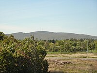
Mount Bélair is a peak in the Laurentian Mountains, Quebec, Canada, with an altitude of 485 m (1,591 ft). It is located in the Val-Bélair section of Quebec City, approximately 24 km (15 mi) west of downtown.
| Mount Bélair | |
|---|---|
| Mont Bélair | |
 View of Mount Bélair from the intersection of Chauveau Avenue and Autoroute Henri-IV. | |
| Highest point | |
| Elevation | 485 m (1,591 ft) |
| Listing | List of mountains in Canada |
| Coordinates | 46°49′23″N 71°29′38″W |
| Geography | |
| Parent range | Laurentian Mountains |
Activities
Mount Bélair is a popular site for outdoor activities. Year round, the summit offers a panoramic view from which one can see downtown Québec, and portions of the trail employ raised wooden walkways.[1] In the autumn, it is decorated with the ornate colors of the boreal forest. In winter, available activities include cross-country skiing, snowshoeing, and walking.[1] During warmer temperatures, one may take advantage of a pool, volleyball and soccer nets, a playground, hiking trails, and campground.[2]
In 2001 a telescope was placed in the park, making it the first and only observatory in Québec City, and club members periodically hold observation nights open to the public (weather permitting).[3]
Telecommunications

The mountain is also used as a transmission site for many of Quebec City's radio stations, as well as for television stations CBVT-DT and CKMI-DT. It is also used as an easement for Hydro-Québec's transmission lines. The Canadian Coast Guard uses the site for VHF Marine communications along the St Lawrence River.
References
- "Parc naturel du mont Bélair" (in French). Association forestière des deux rives. Archived from the original on March 31, 2012.
- "Base de plein air La Découverte" (in French). City of Québec. Archived from the original on December 5, 2011.
- "Histoire" (in French). Club d'astronomie io de Val-Bélair. Retrieved September 3, 2011.
На других языках
[de] Mont Bélair
Der Mont Bélair ist ein 485 Meter hoher Berg in der kanadischen Provinz Québec. Er ist die höchste Erhebung auf dem Gebiet der Provinzhauptstadt Québec und liegt etwa 24 Kilometer westlich des Stadtzentrums im Stadtteil Val-Bélair.- [en] Mount Bélair
[fr] Mont Bélair
Le mont Bélair est une montagne de 485 m située dans le quartier de Val-Bélair, à Québec, au Canada.Другой контент может иметь иную лицензию. Перед использованием материалов сайта WikiSort.org внимательно изучите правила лицензирования конкретных элементов наполнения сайта.
WikiSort.org - проект по пересортировке и дополнению контента Википедии
