geo.wikisort.org - Mountains
The Franklin Mountains of Texas (Spanish: Sierras de los Mansos[1]) are a small range 23 miles (37 km) long, 3 miles (5 km) wide that extend from El Paso, Texas north into New Mexico.[2] The Franklins were formed due to crustal extension related to the Cenozoic Rio Grande rift. Although the present topography of the range and adjoining basins is controlled by extension during rifting in the last 10 million years, faults within the range also record deformation during the Laramide orogeny, between 85 and 45 million years ago.
| Franklin Mountains | |
|---|---|
 Aerial view of the Franklin Mountains from the south, with El Paso's Scenic Drive at the bottom, and New Mexico's Organ Mountains on the horizon in the distance | |
| Highest point | |
| Peak | North Franklin Peak |
| Elevation | 7,192 ft (2,192 m) |
| Coordinates | 31°54′10″N 106°29′36″W |
| Geography | |
| Country | United States |
| States | Texas and New Mexico |
| Geology | |
| Orogeny | Laramide orogeny |
| Age of rock | Cretaceous |
| Type of rock | Sedimentary, Igneous |
The highest peak is North Franklin Peak at 7,192 feet (2,192 m). Much of the range is part of the Franklin Mountains State Park. The mountains are composed primarily of sedimentary rock with some igneous intrusions. Geologists refer to them as tilted-block fault mountains and in them can be found 1.25 billion-year-old Precambrian rocks,[3] the oldest in Texas.[2][4]
Gallery
![View of the south end of Franklin Mountains from El Paso, showing the abrupt termination of the range, its westward dip slope and terraced bolson deposits on each side. (1908)[5]](//upload.wikimedia.org/wikipedia/commons/thumb/2/25/Richardson_1908_FranklinMts.jpg/120px-Richardson_1908_FranklinMts.jpg) View of the south end of Franklin Mountains from El Paso, showing the abrupt termination of the range, its westward dip slope and terraced bolson deposits on each side. (1908)[5]
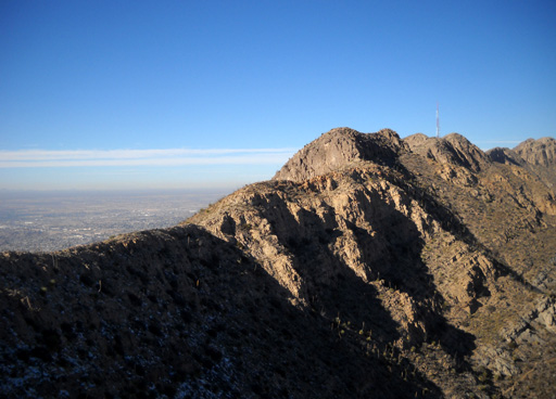
View of the south end of Franklin Mountains from El Paso, showing the abrupt termination of the range, its westward dip slope and terraced bolson deposits on each side. (1908)[5] North Franklin Peak, looking northeast from South Franklin Mountain
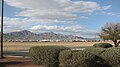 South and North Franklin mountains, shown left to right, El Paso, Texas, as seen from Fort Bliss. The Organ Mountains can be glimpsed to the north, in the right part of the image.
 View of South Franklin Mountain (aka Mount Franklin) (29 March 2009)
 Franklin Mountains with Northwest El Paso in the background
![View of the south end of Franklin Mountains from El Paso, showing the abrupt termination of the range, its westward dip slope and terraced bolson deposits on each side. (1908)[5]](http://upload.wikimedia.org/wikipedia/commons/2/25/Richardson_1908_FranklinMts.jpg)


See also
- Beach Mountains
- Chihuahuan Desert
- Davis Mountains
- Guadalupe Mountains
- McKittrick Canyon
- Trans-Pecos
References
- Miles, Robert W. (2010-06-12). "Franklin Mountains". tshaonline.org. Retrieved 2020-03-29.
- Van Hise, C. R.; Leith, C. K. (1909). Pre-Cambrian Geology of North America. United States Geological Survey, Bulletin. Vol. 360. pp. 746–748. doi:10.3133/b360. OCLC 271845.
- "Franklin Mountains State Park : Interpretive Guide" (PDF). Texas State Parks. 2019. Precambrian rocks can be seen in the Tom Mays unit of the Franklin Mountains park.
- Brooks, A. H. (1904). "The Geological Society of Washington". Science. NS. 19 (490): 794–796. doi:10.1126/science.19.490.794.
- Richardson, G. B. (1909). El Paso folio, Texas. United States Geological Survey, Folios of the Geologic Atlas. Vol. No. 166. Figure 10. doi:10.3133/gf166. OCLC 2514134.
External links
- Franklin Mountains (Texas) from the Handbook of Texas Online
| Authority control: National libraries |
|---|
 | This article about a location in El Paso County, Texas is a stub. You can help Wikipedia by expanding it. |
This New Mexico state location article is a stub. You can help Wikipedia by expanding it. |
На других языках
- [en] Franklin Mountains (Texas)
[it] Monti Franklin (Texas)
I Monti Franklin del Texas sono una catena montuosa (23 miglia di lunghezza, 3 miglia (4,8 km) di larghezza) che si estendono da El Paso, Texas, a nord nel Nuovo Messico.[1] I Franklin si formarono a causa dell'estensione della crosta legata alla spaccatura del rift del Rio Grande durante il Cenozoico. Sebbene l'attuale topografia della catena e dei bacini adiacenti sia controllata dall'estensione durante la spaccatura negli ultimi 10 milioni di anni, le faglie all'interno della catena registrano anche deformazioni avvenute durante l'orogenesi laramide, tra 85 e 45 milioni di anni fa.Другой контент может иметь иную лицензию. Перед использованием материалов сайта WikiSort.org внимательно изучите правила лицензирования конкретных элементов наполнения сайта.
WikiSort.org - проект по пересортировке и дополнению контента Википедии