geo.wikisort.org - Mountains
Enchanted Rock is a pink granite mountain located in the Llano Uplift about 17 miles (27 km) north of Fredericksburg, Texas and 24 miles (39 km) south of Llano, Texas, United States. Enchanted Rock State Natural Area, which includes Enchanted Rock and surrounding land, spans the border between Gillespie and Llano counties, south of the Llano River. Enchanted Rock covers roughly 640 acres (260 ha) and rises around 425 feet (130 m) above the surrounding terrain to an elevation of 1,825 feet (556 m) above sea level. It is the largest pink granite monadnock in the United States. Enchanted Rock State Natural Area, a part of the Texas state park system, includes 1,644 acres (665 ha).[4] In 1936, the area was designated a Recorded Texas Historic Landmark.[5] In 1971, Enchanted Rock was designated as a National Natural Landmark by the National Park Service.[6]
| Enchanted Rock District | |
|---|---|
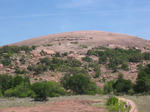 Enchanted Rock, as seen from the trail leading to its summit on a busy hiking day. | |
| Highest point | |
| Elevation | 1,825 ft (556 m)[1] |
| Prominence | 130 m (430 ft) |
| Coordinates | 30°30′24″N 98°49′08″W[2] |
| Geography | |

| |
| Location | near Fredericksburg, Texas, US |
| Geology | |
| Mountain type | granite dome |
Enchanted Rock Archeological District | |
U.S. National Register of Historic Places | |
U.S. Historic district | |
U.S. National Natural Landmark | |
| Area | 1,643 acres (665 ha) |
| NRHP reference No. | 84001740[3] |
| Significant dates | |
| Added to NRHP | August 29, 1984 |
| Designated NNL | 1971 |
Enchanted Rock was rated in 2017 as the best campsite in Texas in a 50-state survey.[7]
Geology
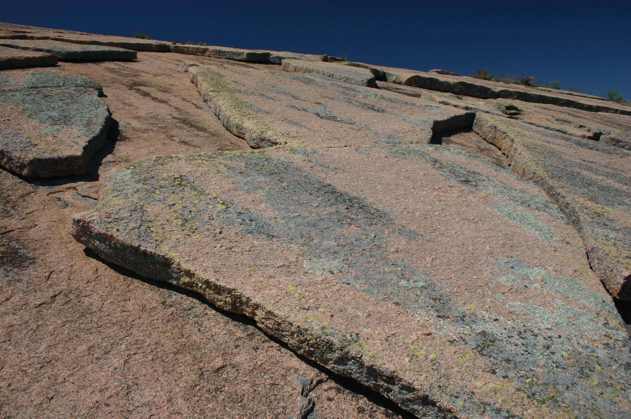
The prominent granite dome is visible for many miles in the surrounding basin of the Llano Uplift. The weathered dome, standing above the surrounding plain, is known to geologists as a monadnock. The rock is actually the visible above-ground part of a segmented ridge, the surface expression of a large igneous batholith, called the Town Mountain Granite[8] of middle Precambrian (1,082 ± 6 million years ago)[9] material that intruded into earlier metamorphic schist, called the Packsaddle Schist.[8] The intrusive granite of the rock mass, or pluton, was exposed by extensive erosion of the surrounding sedimentary rock, primarily the Cretaceous Edwards limestone, which is exposed a few miles to the south of Enchanted Rock.[8]


History

| Timeline of Enchanted Rock History [10][11] | ||
|---|---|---|
| Date | Event | |
| 1838 |
| |
| 1841 |
| |
| 1844 |
| |
| 1880–1881 |
| |
| 1886 |
| |
| 1895 |
| |
| 1927 |
| |
| 1946 |
| |
| 1970 |
| |
| 1978 |
| |
| 1984 |
| |
Archaeological evidence indicates human visitation at the rock going back at least 11,000 years.
According to the book [13] The Enchanted Rock published in 1999 by Ira Kennedy [14][15]
These hunter-gatherers had flint-tipped spears, fire, and stories. With these resources, some 12,000 years ago, the first Texans became the wellspring of Plains Indian culture. On the basis of archaeological evidence, human habitation at Enchanted Rock can be traced back at least 10,000 years. Paleo-Indian projectile points, or arrowheads, 11–12,000 years old, have been found in the area upstream and downstream from the rock. The oldest authenticated projectile point found within the present-day park is a Plainview point type, dating back 10,000 years.
The rock has been the subject of numerous geological surveys and paintings.
Vandalism
In 2016, two citizens of San Marcos, Texas, were arrested for vandalizing the "south face of the summit at Enchanted Rock State Park". The summit was vandalized with graffiti again in 2018 and no arrests have been made in that case. The vandalism is a state felony in Texas, carrying "a penalty of up to two years in state jail and a $10,000 fine if convicted".[16][17]
Legends
Folklore of local Tonkawa, Apache and Comanche tribes ascribes magical and spiritual powers to the rock (hence the name Enchanted Rock). While attempting to hide from Anglo settlers in the area, the natives would hide on the top two tiers of the rock, where they were invisible from the ground below. The first European to visit the area was probably Álvar Núñez Cabeza de Vaca in 1536. The Tonkawa, who inhabited the area in the 16th century, believed that ghost fires flickered at the top of the dome. In particular, they heard unexplained creaking and groaning, which geologists attribute to night-time contraction of the rock after being heated by the sun during the day. The name "Enchanted Rock" derives from Spanish and Anglo-Texan interpretations of such legends and related folklore; the name "Crying Rock" has also been given to the formation.
A plaque formerly embedded in Enchanted Rock near the top, but now removed to a kiosk below, reads:[18]
From its summit in 1841, Captain John C. Hays, while surrounded by Comanche Indians who cut him off from his ranging company repulsed the whole band and inflicted upon them such heavy losses that they fled.
— Marked by the State of Texas 1936
Other legends [19] [20] associated with Enchanted Rock are:
- Named "Spirit Song Rock" for native legends
- Revered by native tribes as a holy portal to other worlds
- Anyone spending the night on the rock becomes invisible
- Spanish priest fled to the rock pursued by native tribes, disappeared, and returned to tell a mystic tale of falling into a cavern and being swallowed by the rock, encountering many spirits in the tunnels, eventually to be spit out two days later
- Haunted by spirits of warriors of a now-extinct Native American tribe who were slaughtered at Enchanted Rock by a rival tribe
- Haunted by a Native American princess who threw herself off the rock after witnessing the slaughter of her people
- Alleged sacrifices at the rock by both Comanche and Tonkawa tribes
- Believed to be a lost silver mine, or the lost El Dorado gold
- Bad fortune and death will befall anyone who climbs the rock with bad intent
- Footprint indentations on the rock of Native American chief who sacrificed his daughter, condemned to walk Enchanted Rock forever
- Woman's screams at night are of a white woman who took refuge on Enchanted Rock after escaping a kidnapping by Native Americans
- Spanish soldier Don Jesús Navarro's Enchanted Rock rescue of native maiden Rosa, daughter of Chief Tehuan, after her kidnap by Comanches intent on sacrificing her on the rock
Flora and fauna


More than 500 species of plants,[21] from four chief plant communities — open oak woodland, mesquite grassland, floodplain, and granite rock community — inhabit the rock. Vernal pools, ecologically threatened depressions of flora and fauna adapted to harsh environments, contain fragile invertebrate fairy shrimp. Other wildlife includes bats, ringtails, squirrels, and foxes. A wide variety of lizards, including the Texas horned lizard, also makes the Enchanted Rock area their home.
Designated a key bird watching site,[22] bird enthusiasts can observe wild turkey, greater roadrunner, golden-fronted woodpecker, Woodhouse's scrub jay, canyon towhee, rufous-crowned sparrow, black-throated sparrow, lesser goldfinch, common poorwill, chuck-will's-widow, black-chinned hummingbird, vermilion flycatcher, scissor-tailed flycatcher, Bell's vireo, yellow-throated vireo, blue grosbeak, painted bunting, orchard oriole, vesper sparrow, fox sparrow, Harris's sparrow, and lark sparrow.
Enchanted Rock State Natural Area and Conservation

Park activities include caving,[23] hiking, primitive backpack camping, rock climbing and picnicking. The Summit Trail[24] is the most popular hiking path.
The Granite Gripper is an annual rock climbing competition that acts as a fundraiser for park conservation through the Friends of Enchanted Rock.[25] Emphasis is placed on activity safety and ecological preservation. Visitors are asked to keep human incursion at a minimum by not disturbing plants, animals, or artifacts.[26] Federal and state statutes, regulations, and rules governing archeological and historic sites apply.[27] The state Game Warden as a commissioned peace officer is authorized to inspect natural resources and take any necessary action for the preservation of the resources.[28] As of March 1, 2016, dogs are not allowed on the summit trail anymore.
Texas Parks and Wildlife Department partners with Friends of Enchanted Rock,[29] a volunteer-based nonprofit organization that works for the improvement and preservation of Enchanted Rock State Natural Area. Scheduled Summit Trail tours are the third Saturday of the month starting April, May, September, October, November, and December. Private tours are available for groups at other times.
See also
- Albert, Texas
- Cherry Springs Dance Hall
- Doss, Texas
- Easter Fire
- Harper, Texas
- List of National Natural Landmarks in Texas
- National Register of Historic Places listings in Gillespie County, Texas
- National Register of Historic Places listings in Llano County, Texas
- Spy Rock
- Stonewall, Texas
- Texas Hill Country
![]() National Register of Historic Places portal
National Register of Historic Places portal
![]() Texas portal
Texas portal
References
- "Enchanted Rock, Texas". Peakbagger.com. Retrieved 2012-12-27.
- "Enchanted Rock". Geographic Names Information System. United States Geological Survey, United States Department of the Interior. Retrieved 2012-12-27.
- "National Register Information System". National Register of Historic Places. National Park Service. July 9, 2010.
- "State Natural Area, Enchanted Rock". Texas Parks and Wildlife Dept. Retrieved 6 May 2010. Texas Parks and Wildlife Dept
- "Details for Enchanted Rock (Atlas Number 5171010035)". Texas Historic Sites Atlas. Texas Historical Commission. Retrieved May 17, 2017.
- "National Natural Landmarks - National Natural Landmarks (U.S. National Park Service)". www.nps.gov. Retrieved 2019-03-30.
Year designated: 1971
- "The best campsite in every state". Msn.com. Retrieved June 8, 2017.
- University of Texas at Austin, Bureau of Economic Geology, Barnes, V.E., Hartmann, Barbara and Scranton, D.F., 1992, Geologic map of Texas: University of Texas at Austin, Bureau of Economic Geology, scale 1:500000.
- Walker, Nicholas, Middle Proterozoic geologic evolution of Llano uplift, Texas: Evidence from U-Pb zircon geochronometry, Geological Society of America Bulletin 1992;104;494–504
- Kohout, Martin Donell: State Natural Area, Enchanted Rock from the Handbook of Texas Online. Retrieved 6 May 2010. Texas State Historical Association
- "History, Enchanted Rock State Natural Area". Texas Parks and Wildlife Dept. Retrieved 6 May 2010. Texas Parks and Wildlife Dept
- "National Landmark, Enchanted Rock". National Park Service. Retrieved 6 May 2010. National Park Service
- "History, The Enchanted Rock". TexFiles. Retrieved 6 May 2010. TexFiles
- "Kennedy, Ira – Bio". TexFiles. Retrieved 6 May 2010. TexFiles
- "Kennedy, Ira – Articles". TexFiles. Retrieved 6 May 2010. TexFiles
- "Enchanted Rock vandalized again with graffiti". February 27, 2018. Retrieved January 28, 2021.
- "Suspects in Enchanted Rock Vandalism Arrested". April 6, 2016. Retrieved May 17, 2018.
- "Hays, John C. – Plaque". Alison Chains – Flickr. Retrieved 6 May 2010.
- Kohout, Martin Donell: Legends, Enchanted Rock from the Handbook of Texas Online. Retrieved 6 May 2010. Texas State Historical Association
- "Legends & History of Sacred Enchanted Rock". Scribd. Archived from the original on 23 November 2009. Retrieved 6 May 2010. Texas Tourism Press
- "Photo Experience and Plant Life, Enchanted Rock". Enchanted Rock State Natural Area. Archived from the original on 27 April 2010. Retrieved 6 May 2010. Enchanted Rock State Natural Area
- "Bird Watching Sites, Enchanted Rock State Natural Area". Trails.com. Retrieved 6 May 2010. Trails.com
- "Caving at Enchanted Rock State Park (a video tour)". Morning Star Productions. Archived from the original on 2021-12-22. Retrieved 6 May 2010. Morning Star Productions
- "Summit Trail, Enchanted Rock". Austin Explorer. Retrieved 6 May 2010. Barron, Robert
- "Friends of Enchanted Rock". friendsofenchantedrock.com. Retrieved October 2, 2018.
- "Information Brochure, Enchanted Rock State Natural Area" (PDF). Texas Parks and Wildlife Dept. Retrieved 6 May 2010. Texas Parks and Wildlife Dept
- "Federal-State statutes, regulations, rules". Texas Historical Commission. Archived from the original on 2 January 2012. Retrieved 6 January 2012.
- "Game Warden". Texas Parks and Wildlife. Retrieved 6 January 2012.
- "Friends of Enchanted Rock". Friends of Enchanted Rock. Retrieved 29 Sep 2010.
Further reading
- Dobie, J Frank; Estill, Julia (1995). "The Enchanted Rock in Llano County". Legends of Texas: Volume II: Pirates' Gold and Other Tales. Pelican Publishing. pp. 78–82. ISBN 978-1-56554-073-6.
- Allred, Lance (2009). Enchanted Rock: A Natural and Human History. University of Texas Press. ISBN 978-0-292-71963-7.
- Moore, Stephen L (2007). "Enchanted Rock and Bird's Fort". Savage Frontier: 1840–1841: Rangers, Riflemen, and Indian Wars in Texas. University of North Texas Press. ISBN 978-1-57441-228-4.
External links
- Enchanted Rock State Natural Area
- Texas Parks official web page
- Enchanted Rock from the Handbook of Texas Online
- E-Rock: Virtual Trip to Enchanted Rock
- Technical rock climbing at Enchanted Rock
- Home movie of Enchanted Rock, The Steve Gomez Collection, no. 1 - Hiking Enchanted Rock, Texas Archive of the Moving Image
National landmarks and sites in Gillespie County, Texas, United States | ||
|---|---|---|
| National Historic Park |
|  |
| National Historic Landmark |
| |
| National Natural Landmark |
| |
| National Historic District |
| |
| National Historic Places |
| |
| ||
National landmarks and sites in Llano County, Texas, United States | ||
|---|---|---|
| National Natural Landmark |
| |
| National Historic District |
| |
| National Historic Places |
| |
| ||
National Register of Historic Places in Texas | ||
|---|---|---|
| Lists by county |
| |
| National Parks |
| |
| Other lists |
| |
| ||
Austin–Round Rock–San Marcos | |||||
|---|---|---|---|---|---|
| Central city |  | ||||
| Satellite cities | |||||
| Other communities |
| ||||
| Counties |
| ||||
| Parks and preserves |
| ||||
| Geography |
| ||||
| Bodies of water | |||||
| Transportation |
| ||||
На других языках
- [en] Enchanted Rock
[fr] Enchanted Rock
Enchanted Rock (littéralement « rocher enchanté ») est un énorme rocher de granite rose faisant partie de la formation de Llano Uplift, environ 24 km au nord de Fredericksburg au Texas (États-Unis) et à 24 km au sud de Llano. Sa superficie est d'environ 2,6 km2, son dénivelé de 130 mètres et son altitude de 556 mètres. Il s'agit du deuxième plus important monadnock de granite des États-Unis derrière Stone Mountain en Géorgie. Il est protégé au sein de l'aire naturelle d'État d'Enchanted Rock, qui s'étend sur 6,7 km2.[it] Enchanted Rock
Enchanted Rock (roccia incantata) è un enorme masso di granito rosa situato nella regione del Llano Uplift, posta circa 24 chilometri a nord della città di Fredericksburg, in Texas e 24 km a sud della città di Llano.[ru] Энчантед-Рок
Энчантед-Рок (англ. Enchanted Rock) — огромный розовый гранитный батолит, который находится в 27 километрах к северу от города Фредериксберга в штате Техас, США. Энчантед-Рок и земли около него входят в состав природного заповедника Энчантед-Рок, который охватывает земли на границе округов Гиллеспи и Ллано и находится на юге от реки Ллано. Батолит занимает площадь около 260 га и является одним из крупнейших гранитных батолитов в США. Природный заповедник Энчантед-Рок занимает площадь около 665 гектаров[2].Другой контент может иметь иную лицензию. Перед использованием материалов сайта WikiSort.org внимательно изучите правила лицензирования конкретных элементов наполнения сайта.
WikiSort.org - проект по пересортировке и дополнению контента Википедии