geo.wikisort.org - Island
Thurston Island is an ice-covered, glacially dissected island, 215 km (134 mi) long, 90 km (56 mi) wide and 15,700 km2 (6,062 sq mi) in area, lying a short way off the northwest end of Ellsworth Land, Antarctica. It is the third-largest island of Antarctica, after Alexander Island and Berkner Island.
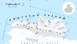 Map of Thurston Island | |
 Thurston Location of Thurston Island | |
| Geography | |
|---|---|
| Location | Antarctica |
| Coordinates | 72°6′S 99°0′W |
| Area | 15,700 km2 (6,100 sq mi) |
| Area rank | 56th |
| Length | 215 km (133.6 mi) |
| Width | 90 km (56 mi) |
| Highest elevation | 750 m (2460 ft) |
| Highest point | Mount Howell |
| Administration | |
| Administered under the Antarctic Treaty System | |
The island was discovered from the air by Rear Admiral Byrd on February 27, 1940, who named it for W. Harris Thurston, a New York textile manufacturer, designer of the windproof "Byrd Cloth" and sponsor of Antarctic expeditions.[1] Thurston Island is separated from the mainland by Peacock Sound, which is occupied by the western portion of Abbot Ice Shelf.[2] It divides Bellingshausen Sea to the east from Amundsen Sea to the west.
Originally mistaken as a peninsula, the feature was not recognised an island until 1960.[2]
Geography
The western extremity of the island is Cape Flying Fish.[3] The eastern extremity is Cape Annawan, off Tierney Peninsula.[4] The southeast end of the island is Cape Walker.[5]
The island is divided south-north by the Walker Mountains, a range of peaks and nunataks.[6] Several other peaks are situated on the Edwards and Noville Peninsulas. There are many glaciers on Thurston Island.
Features by coast
North coast
The north coast of the island is indented by a series of alternating inlets and peninsulas. Cape Petersen forms the westernmost portion of the northern coast. East of that is Jones Peninsula, then Dyer Point and Hughes Peninsula. Henry Inlet indents the coast to the east, and Tinglof Peninsula forms its eastern shore. Wagoner Inlet is east of that, followed by Starr Peninsula. Glacier Bight is to the east, and just north off the coast from them are the hazardous Porters Pinnacles. East of Starr Peninsula are Potaka Inlet, Kearns Peninsula, followed by Peale Inlet. The larger Noville Peninsula is to the east. It is bordered by Murphy Inlet, whose southern end is split into two prongs by Linsley Peninsula and Ball Peninsula. Edwards Peninsula, Koether Inlet, and the larger Evans Peninsula are to the east. Cadwalader Inlet, Lofgren Peninsula, and Morgan Inlet form the northeastern coast.
East coast

The easternmost point of the island is Tierney Peninsula, southeast of which is Seraph Bay. Simpson Bluff, a broad ice-covered bluff, sits between Levko Glacier and Savage Glacier where they enter the bay.[7] Nearby Baker Knob is a small rounded coastal elevation which has an abrupt east face.[8] Both Simpson Bluff and Baker Knob were named by the Advisory Committee on Antarctic Names (US-ACAN) for personnel from the Eastern Group of U.S. Navy Operation HIGHJUMP: Photographer's Mates R.M. Simpson and T.W. Baker, respectively. Operation HIGHJUMP obtained aerial photographs of Thurston Island and adjacent coastal areas in 1946-47.[7][8]
Snow-covered Harrison Nunatak stands 4 nautical miles (7 km) south of Savage Glacier. It was discovered on helicopter flights from the USS Burton Island (AGB-1) and USS Glacier (AGB-4) during the U.S. Navy Bellingshausen Sea Expedition in February 1960, and was named by US-ACAN for Henry T. Harrison Jr., a U.S. Weather Bureau meteorologist with the Byrd Antarctic Expedition in 1928–30.[9][10]
The southeast point of the island is Cape Walker.
South coast
On the south side of the island are King Peninsula, Williamson Peninsula, Evans Point, and Von der Wall Point, projecting into Peacock Sound. Williamson Peninsula is bordered by Schwartz Cove and O'Dowd Cove.
Shelton Head is a headland marked by exposed rock, located 12 nmi (22 km) west of Long Glacier on the south coast of Thurston Island. It was mapped by the United States Geological Survey (USGS) from surveys and U.S. Navy air photos, 1960–66, and named by US-ACAN for John A. Shelton meteorologist at Byrd Station, 1963-64.[11]
Prickly Ridge is a rounded ice-covered ridge 4 nmi (7.4 km) west of Shelton Head on the south side of Thurston Island. The descriptive name was given by the Advisory Committee on Antarctic Names (US-ACAN); small dispersed nunataks rise above the ice surface, giving the feature a prickly appearance.[12] Belknap Nunatak, an ice-covered spur, is the largest outcrop on the ridge. It was mapped by the USGS from surveys and from U.S. Navy air photos, 1960–66, and named by US-ACAN for William Belknap, a field assistant at Byrd Station, 1964–65.[13]
See also
- Composite Antarctic Gazetteer
- List of Antarctic and sub-Antarctic islands
- List of Antarctic islands south of 60° S
- Scientific Committee on Antarctic Research
- Territorial claims in Antarctica
Further reading
- International Symposium on Antarctic Earth Sciences 5th : 1987, Geological Evolution of Antarctica, Cambridge, England, P 401
- A.M. GRUNO, D. V. Kent, I. W. D. Dalzeil, New Paleomagnetic Data From Thurston Island' Implications for the Tectonics of West Antarctica and Weddell Sea Opening, JOURNAL OF GEOPHYSICAL RESEARCH, VOL. 96, NO. Bll, PAGES 17,935-17,954, OCTOBER 10, 1991
References
- "Thurston Island". Geographic Names Information System. United States Geological Survey, United States Department of the Interior. Retrieved 29 August 2018.
- "Antarctic Gazetteer: Thurston Island". Australian Antarctic Division. Archived from the original on 26 September 2007. Retrieved 26 January 2008.
- "Cape Flying Fish". Geographic Names Information System. United States Geological Survey, United States Department of the Interior. Retrieved 29 August 2018.
- "Cape Annawan". Geographic Names Information System. United States Geological Survey, United States Department of the Interior. Retrieved 29 August 2018.
- "Cape Walker". Geographic Names Information System. United States Geological Survey, United States Department of the Interior. Retrieved 29 August 2018.
- "Walker Mountains". Geographic Names Information System. United States Geological Survey, United States Department of the Interior. Retrieved 29 August 2018.
- "Simpson Bluff". Geographic Names Information System. United States Geological Survey, United States Department of the Interior. Retrieved 29 August 2018.
- "Baker Knob". Geographic Names Information System. United States Geological Survey, United States Department of the Interior. Retrieved 17 May 2011.
- "Harrison Nunatak". Geographic Names Information System. United States Geological Survey, United States Department of the Interior. Retrieved 28 May 2012.
- Alberts, Fred G., ed. (June 1995). Geographic Names of the Antarctic (PDF) (second ed.). United States Board on Geographic Names. p. 314. Retrieved 5 April 2012.
- "Shelton Head". Geographic Names Information System. United States Geological Survey, United States Department of the Interior. Retrieved 29 August 2018.
- "Prickly Ridge". Geographic Names Information System. United States Geological Survey, United States Department of the Interior. Retrieved 29 August 2018.
- "Belknap Nunatak". Geographic Names Information System. United States Geological Survey, United States Department of the Interior. Retrieved 29 August 2018.
![]() This article incorporates public domain material from websites or documents of the United States Geological Survey.
This article incorporates public domain material from websites or documents of the United States Geological Survey.
Antarctica | ||||||||
|---|---|---|---|---|---|---|---|---|
| Geography |
|  | ||||||
| History |
| |||||||
| Politics |
| |||||||
| Society |
| |||||||
| Famous explorers |
| |||||||
| ||||||||
| Authority control |
|---|
На других языках
[de] Thurston-Insel
Die Thurston-Insel (engl. Thurston Island) ist eine im Südpolarmeer gelegene, eisbedeckte, zerklüftete und vergletscherte Insel vor der Eights-Küste im westantarktischen Ellsworthland.- [en] Thurston Island
[es] Isla Thurston
La isla Thurston (72°06′S 99°00′O) está cubierta por el hielo, de 215 kilómetros de largo por 90 kilómetros de ancho y 15 700 km² de área, estando al NW de la Tierra de Ellsworth, Antártida. Es la tercera isla más grande de la Antártida, después de la isla Alejandro I y la isla Berkner. La isla está separada del continente por el estrecho de Peacock, que está ocupado por la parte occidental de la barrera de hielo Abbot. La isla Thurston no es reclamada por ningún país.[fr] Île Thurston
L'île Thurston est une île côtière située dans la mer de Bellingshausen dans l'océan Antarctique, au sud-ouest de la péninsule Antarctique.[it] Isola Thurston
L'isola Thurston (in inglese Thurston Island) è un'isola antartica.[ru] Терстон (остров)
Те́рстон (англ. Thurston Island) — покрытый льдом остров, расположенный в Антарктиде, около северо-западного побережья Земли Элсуэрта.Другой контент может иметь иную лицензию. Перед использованием материалов сайта WikiSort.org внимательно изучите правила лицензирования конкретных элементов наполнения сайта.
WikiSort.org - проект по пересортировке и дополнению контента Википедии