geo.wikisort.org - Mountains
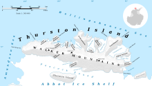
Walker Mountains (72°13′S 99°2′W) is a range of peaks and nunataks which are fairly well separated but trend east–west to form the axis, or spine, of Thurston Island in Antarctica. They were discovered by Rear Admiral Byrd and members of the US Antarctic Service in a flight from the ship Bear on February 27, 1940. It was named by the Advisory Committee on Antarctic Names for Lt. William M. Walker, captain of the United States Exploring Expedition ship Island on March 23, 1839.


Peaks
- Mount Borgeson
- Mount Bramhall
- Mount Caldwell
- Dickens Peak
- Mount Hawthorne
- Mount Kazukaitis
- Landfall Peak
- Mount Leech
- Litz Bluff
- Mount Lopez
- Lowe Nunataks
- Mount Noxon
- Parker Peak
- Mount Simpson
- Smith Peak (Antarctica)
- Zuhn Bluff
Maps
- Thurston Island – Jones Mountains. 1:500000 Antarctica Sketch Map. US Geological Survey, 1967.
- Antarctic Digital Database (ADD). Scale 1:250000 topographic map of Antarctica. Scientific Committee on Antarctic Research (SCAR), 1993–2016.
![]() This article incorporates public domain material from "Walker Mountains". Geographic Names Information System. United States Geological Survey.
This article incorporates public domain material from "Walker Mountains". Geographic Names Information System. United States Geological Survey.
На других языках
[de] Walker Mountains
Die Walker Mountains sind ein Gebirgszug aus Berggipfeln und Nunatakkern, der sich in ostwestlicher Ausrichtung über die gesamte Länge der Thurston-Insel vor der Eights-Küste des westantarktischen Ellsworthlands erstreckt.- [en] Walker Mountains
[it] Montagne di Walker
Le montagne di Walker sono una catena montuosa situata sull'isola Thurston, al largo della costa di Eights, nella Terra di Ellsworth, in Antartide. La catena si estende in direzione est-ovest per tutta la lunghezza dell'isola, ossia circa 215 km, occupandola anche in tutta la sua larghezza, e raggiunge l'altezza di circa 623 m s.l.m con il picco Parker.[1]Текст в блоке "Читать" взят с сайта "Википедия" и доступен по лицензии Creative Commons Attribution-ShareAlike; в отдельных случаях могут действовать дополнительные условия.
Другой контент может иметь иную лицензию. Перед использованием материалов сайта WikiSort.org внимательно изучите правила лицензирования конкретных элементов наполнения сайта.
Другой контент может иметь иную лицензию. Перед использованием материалов сайта WikiSort.org внимательно изучите правила лицензирования конкретных элементов наполнения сайта.
2019-2025
WikiSort.org - проект по пересортировке и дополнению контента Википедии
WikiSort.org - проект по пересортировке и дополнению контента Википедии
