geo.wikisort.org - Mountains
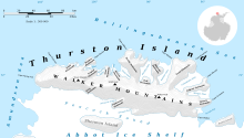
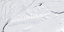
Mount Bramhall (72°15′S 98°16′W) is a peak of the Walker Mountains, located 5 nautical miles (9 km) east of Mount Hawthorne on Thurston Island. It was first delineated from aerial photographs taken by U.S. Navy Operation Highjump in December 1946, and named by the Advisory Committee on Antarctic Names for Dr. E.H. Bramhall, a physicist of the Byrd Antarctic Expedition in 1933–35.[1]


See also
- Mountains in Antarctica
Maps
- Thurston Island – Jones Mountains. 1:500000 Antarctica Sketch Map. US Geological Survey, 1967.
- Antarctic Digital Database (ADD). Scale 1:250000 topographic map of Antarctica. Scientific Committee on Antarctic Research (SCAR). Since 1993, regularly upgraded and updated.
References
- "Bramhall, Mount". Geographic Names Information System. United States Geological Survey, United States Department of the Interior. Retrieved 17 August 2011.
![]() This article incorporates public domain material from the United States Geological Survey document: "Bramhall, Mount". (content from the Geographic Names Information System)
This article incorporates public domain material from the United States Geological Survey document: "Bramhall, Mount". (content from the Geographic Names Information System)
На других языках
[de] Mount Bramhall
Mount Bramhall ist ein Berg auf der Thurston-Insel vor der Eights-Küste des westantarktischen Ellsworthlands. In den Walker Mountains ragt er 8 km östlich des Mount Hawthorne auf.- [en] Mount Bramhall
Текст в блоке "Читать" взят с сайта "Википедия" и доступен по лицензии Creative Commons Attribution-ShareAlike; в отдельных случаях могут действовать дополнительные условия.
Другой контент может иметь иную лицензию. Перед использованием материалов сайта WikiSort.org внимательно изучите правила лицензирования конкретных элементов наполнения сайта.
Другой контент может иметь иную лицензию. Перед использованием материалов сайта WikiSort.org внимательно изучите правила лицензирования конкретных элементов наполнения сайта.
2019-2025
WikiSort.org - проект по пересортировке и дополнению контента Википедии
WikiSort.org - проект по пересортировке и дополнению контента Википедии
