geo.wikisort.org - Coast
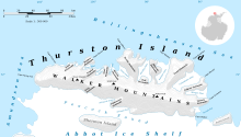
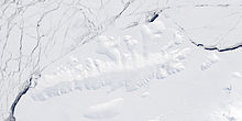
Lofgren Peninsula (72°12′S 96°4′W) is an ice-covered peninsula about 22 nautical miles (40 km) long, projecting between Cadwalader Inlet and Morgan Inlet on the northeast side of Thurston Island, Antarctica. The northern extremity of the peninsula is Cape Menzel, a bold rock cape. These features were discovered in helicopter flights from the USS Burton Island and the USS Glacier of the U.S. Navy Bellingshausen Sea Expedition in February 1960, and were named by the Advisory Committee on Antarctic Names (US-ACAN). The peninsula was named for Charles E. Lofgren, personnel officer with the Byrd Antarctic Expedition, 1928–30.[1] The cape was named for Reinhard W. Menzel, a geomagnetist-seismologist with the Eights Station winter party, 1965.[2]


Named features
Walsh Knob is a small but distinctive ice-covered elevation that rises midway along the south side of the peninsula. It has a rounded appearance except for a cliff at the south side. It was named by the US-ACAN after R.W. Walsh, Photographer's Mate in the Eastern Group of U.S. Navy Operation Highjump, which obtained aerial photographs of Thurston Island and adjacent coastal areas, 1946–47.[3]
Mills Cliff is an isolated rock cliff in the north-central part of the peninsula. It was named by US-ACAN after Aviation Machinist's Mate William H. Mills, an aircrewman in the Eastern Group of Operation Highjump.[4]
Maps
- Thurston Island – Jones Mountains. 1:500000 Antarctica Sketch Map. US Geological Survey, 1967.
- Antarctic Digital Database (ADD). Scale 1:250000 topographic map of Antarctica. Scientific Committee on Antarctic Research (SCAR), 1993–2016.
References
- "Lofgren Peninsula". Geographic Names Information System. United States Geological Survey, United States Department of the Interior. Retrieved 28 June 2013.
- "Cape Menzel". Geographic Names Information System. United States Geological Survey, United States Department of the Interior. Retrieved 19 September 2013.
- "Walsh Knob". Geographic Names Information System. United States Geological Survey, United States Department of the Interior. Retrieved 29 August 2018.
- "Mills Cliff". Geographic Names Information System. United States Geological Survey, United States Department of the Interior. Retrieved 18 October 2013.
![]() This article incorporates public domain material from "Lofgren Peninsula". Geographic Names Information System. United States Geological Survey.
This article incorporates public domain material from "Lofgren Peninsula". Geographic Names Information System. United States Geological Survey.
На других языках
[de] Lofgren-Halbinsel
Die Lofgren-Halbinsel ist eine 35 km lange und vereiste Halbinsel am nordöstlichen Ende der Thurston-Insel vor der Eights-Küste des westantarktischen Ellsworthlands, die im Kap Menzel seewärts endet. Sie liegt zwischen dem Cadwalader Inlet und dem Morgan Inlet. Im nordzentralen Teil der Lofgren-Halbinsel ragt das Mills-Kliff auf. Auf halber Strecke der Südküste befindet sich der Walsh Knob, ein vereister Hügel.- [en] Lofgren Peninsula
Другой контент может иметь иную лицензию. Перед использованием материалов сайта WikiSort.org внимательно изучите правила лицензирования конкретных элементов наполнения сайта.
WikiSort.org - проект по пересортировке и дополнению контента Википедии