geo.wikisort.org - Island
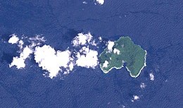
Mborokua (also known as Mary Island) is an uninhabited, jungle-covered volcanic island 30 km west of the Russell Islands. It is occasionally visited by local fishermen, as well as by dive tours.
This article does not cite any sources. (February 2018) |
Nickname: Mary Island | |
|---|---|
 Landsat image of Mborokua Island, Solomon islands | |
| Geography | |
| Coordinates | 9°01′S 158°44′E |
| Area | 4 km2 (1.5 sq mi) |
| Administration | |
| Province | |
| Demographics | |
| Population | uninhabited |
See also
- Desert island
- List of islands
External links
- Satellite view of Mborokua from Google Maps
На других языках
[de] Mborokua
Mborokua, früher auch Mary Island genannt, ist eine kleine Insel in der Westprovinz des Inselstaats der Salomonen. Es ist eine Vulkaninsel, mit einer nach Süden hin offenen Caldera, die eine Meeresbucht bildet.- [en] Mborokua
Текст в блоке "Читать" взят с сайта "Википедия" и доступен по лицензии Creative Commons Attribution-ShareAlike; в отдельных случаях могут действовать дополнительные условия.
Другой контент может иметь иную лицензию. Перед использованием материалов сайта WikiSort.org внимательно изучите правила лицензирования конкретных элементов наполнения сайта.
Другой контент может иметь иную лицензию. Перед использованием материалов сайта WikiSort.org внимательно изучите правила лицензирования конкретных элементов наполнения сайта.
2019-2025
WikiSort.org - проект по пересортировке и дополнению контента Википедии
WikiSort.org - проект по пересортировке и дополнению контента Википедии