geo.wikisort.org - Island
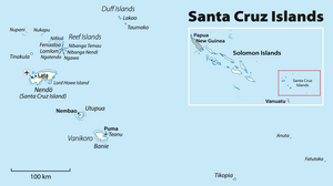
Fatutaka, Fatu Taka or Patu Taka (also known as Fataka and Mitre Island)[1][2] is a small high island in the Solomon Islands province of Temotu in the south-west Pacific Ocean. The easternmost of the Solomon Islands, Fatutaka is located c. 32 km (20 mi) southeast of Anuta and can be seen from there in clear weather.[3][2] Fatutaka and Anuta were discovered by Admiral Edward Edwards in 1791.[4]

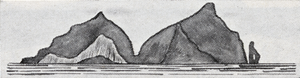
The island, located at 11°54′36″S 170°11′24″E, is a small rocky outcropping, rising to an elevation of 122 m (400 ft). The total land area of the island is 18 ha (44 acres).[citation needed]
Human activities
The island's soil is rocky, and not especially fertile, although it has in the past been used as a gardening location for the people of Anuta.[citation needed]
The population of Anuta, the closest inhabited island, regularly sail to Fatutaka to eat and collect sea-birds and their eggs.[3] The birds of Fatukaka have never been surveyed although the presence of Frigatebird, Eastern Reef Egret, Pacific Imperial Pigeon, and Emerald Dove have been reported.[2][5]
Geology
Fatutaka is one of numerous volcanic highs, islands and banks, in the north-western North Fiji Basin south of the fossil Vitiaz Trench (10°30'–19°S, 169°–174°E). These highs are, however, located up to 240 km (150 mi) from the Vitiaz Trench and do not form a continuous chain derived from the trench, but are a series of massifs aligned on north–south trending faults. Anuta and Fatutaka consist of basaltic lavas and andesitic breccias.[6]
In the 1970s the formation of Anuta and Fatutaka 2.2 Ma was attributed to volcanism in the Vitiaz island arc during the initial back-arc opening of the North Fiji Basin. The Vitiaz Arc volcanoes were, however, displaced in an earlier episode and the formation of the islands is now attributed to renewed volcanism associated with a change in motion of the Pacific Plate 2 Ma.[7]
See also
- Oceania
- Pacific Islands
- Santa Cruz Islands
References
Notes
- Feinberg 1988, p. 181
- Steadman, Pahlavan & Kirch 1990, pp. 119–120
- Kirch 2002, p. 76
- Quanchi & Robson 2005, Pacific Islands and Their First European Visitors, pp. xiii–xxv
- Tarburton 2015
- Pelletier, Lafoy & Missegue 1993, p. 1153
- Kroenke 1995, Northern New Hebrides Back-Arc Area, pp. 21–22
Sources
- Feinberg, Richard (1988). Polynesian Seafaring and Navigation: Ocean Travel in Anutan Culture and Society. Kent State University Press. ISBN 9780873387880. Retrieved 2009-10-16.
- Kirch, P. V. (2002). "Te Kai Paka-Anuta: food in a Polynesian outlier society". Le Journal de la Société des Océanistes. 114–115 (114–115): 71–89. doi:10.4000/jso.1404. Retrieved 2 April 2017.
- Kroenke, L. W. (1995). A Morphotectonic Interpretation of SOPACMAPS 1: 500 000 Charts: Central Solomon Islands-Southern Tuvalu (PDF) (Report). SOPMAC Technical report 220. South Pacific Applied Geoscience Commission. Retrieved 2 April 2017.
- Pelletier, B.; Lafoy, Y.; Missegue, F. (1993). "Morphostructure and magnetic fabric of the northwestern North Fiji Basin". Geophysical Research Letters. 20 (12): 1151–1154. Bibcode:1993GeoRL..20.1151P. doi:10.1029/93gl01240. Retrieved 2 April 2017.
- Steadman, D. W.; Pahlavan, D. S.; Kirch, P. V. (1990). "Extinction, biogeography, and human exploitation of birds on Tikopia and Anuta, Polynesian outliers in the Solomon Islands" (PDF). Bishop Mus. Occas. Pap. 30: 118–153. Retrieved 2 April 2017.
- Tarburton, M. K. (12 June 2015). "Fataka (Mitre) Island Bird Checklist" (PDF). Birds of Melanesia. Retrieved 2 April 2017.
- Quanchi, M.; Robson, J. (2005). Historical dictionary of the discovery and exploration of the Pacific islands. Scarecrow Press. ISBN 9780810865280. Retrieved 2 April 2017.
| Central | |
|---|---|
| Choiseul | |
| Guadalcanal | |
| Isabel | |
| Makira-Ulawa |
|
| Malaita | |
| Rennell and Bellona |
|
| Temotu | |
| Western |
|
This Solomon Islands location article is a stub. You can help Wikipedia by expanding it. |
На других языках
[de] Fatutaka
Fatutaka (tikopianisch für „Abgeschiedener Stein“[1]), auch bekannt als Fatu Taka, Patutaka, Fatacca, Mitre (englisch für „Bischofsmütze“), oder Fataka als lautmalerische Transkription aus der Tikopianischen Sprache, ist eine unbewohnte Vulkaninsel im südlichen Pazifischen Ozean. Sie liegt in der Gruppe der Santa-Cruz-Inseln und gehört politisch zur Provinz Temotu der Inselrepublik Salomonen. Fatutaka ist als östlichste Insel der Salomonen mehr als 1140 Kilometer von der Hauptstadt Honiara entfernt.- [en] Fatutaka
[es] Fatutaka
Fatutaka o Fatu Taka es una pequeña isla de origen volcánico de las Islas Salomón, en el sur del océano Pacífico, situada en la provincia de Temotu. Se trata de la recalada situada más al este del país. Se trata del afroramiento sobre el nivel del mar de un volcán extinguido, que llega a elevarse 122 metros. Tiene una superficie de 0,18 km². Dista aproximadamente 60 km de la isla de Anuta, cuyos habitantes la empleaban para la jardinería.[fr] Fatutaka
Fatutaka ou Fatu Taka est une île inhabitée des Salomon située dans les îles Santa Cruz. Il s'agit de l'île la plus orientale du pays.[it] Fatutaka
Fatutaka (conosciuta anche come Fatu Taka o Patu Taka) è una piccola isola di origine vulcanica, facente parte del gruppo delle Isole Santa Cruz. È il punto più a Est delle Isole Salomone.[ru] Фатутака
Фатутака (англ. Fatutaka) (Также известный как, Фату Така, Пату Така, Остров Митрэ)[1] — небольшой вулканический остров входит в состав провинции Темоту Соломоновых Островов.Другой контент может иметь иную лицензию. Перед использованием материалов сайта WikiSort.org внимательно изучите правила лицензирования конкретных элементов наполнения сайта.
WikiSort.org - проект по пересортировке и дополнению контента Википедии