geo.wikisort.org - Island
The Matsu Islands (UK: /ˌmætˈsuː/ or US: /ˌmɑːtˈsuː/,[4] Chinese: 馬祖列島; pinyin: Mǎzǔ Lièdǎo; Wade–Giles: Ma³-tsu³ Lieh⁴-tao³; Foochow Romanized: Mā-cū liĕk-dō̤), officially Lienchiang County (/ljɛnˈdʒjɑːŋ/, Chinese: 連江縣; pinyin: Liánjiāng Xiàn; Wade–Giles: Lien²-chiang¹ Hsien⁴; Foochow Romanized: Lièng-gŏng-gâing), are an archipelago of 36 islands and islets in the East China Sea governed by the Republic of China (ROC) based in Taiwan, with its location sitting alongside southeastern coast of mainland China. It is the smallest county in the ROC-controlled territories by area and population, as well as one of two counties that were part of the nominal Fujian Province.
Lienchiang County
連江縣 Matsu Islands, Ma-tsu, Matsoo | |
|---|---|
County | |
 Top: Magan Tianhou Temple in Nangan, Bottom left: Matsu display monument in Nangan, Bottom upper left: Lin Moniang Tomb in Mazu Temple, Bottom lower right: Dongyong Lighthouse | |
 Flag  Emblem Logo | |
 | |
| Coordinates: | |
| Country | |
| Province | Fujian / Fukien (nominal subdivision) |
| Region | Northern Fujian |
| Seat | Nangan Township (Nankan) |
| Divisions | 4 rural townships 22 rural villages |
| Government | |
| • County Magistrate | Liu Cheng-ying (KMT) |
| Area | |
| • Total | 29.60 km2 (11.43 sq mi) |
| • Rank | 22 of 22 |
| Population (June 2016)[3] | |
| • Total | 12,716 |
| • Rank | 22 of 22 |
| • Density | 430/km2 (1,100/sq mi) |
| Demonym | Matsunese |
| Time zone | UTC+8 (Taiwan National Standard Time) |
| ISO 3166 code | TW-LIE |
| Website | www.matsu.gov.tw |
| Symbols | |
| Bird | Chinese crested tern (Sterna bernsteini) |
| Flower | Hairy bougainvillea (Bougainvillea glabra) |
| Tree | Australian laurel (Pittosporum tobira) |
| Coastline | 133 km (82.6 mi)[2] |
| Matsu Islands | |||||||||||||||||||||||||||||||||||
|---|---|---|---|---|---|---|---|---|---|---|---|---|---|---|---|---|---|---|---|---|---|---|---|---|---|---|---|---|---|---|---|---|---|---|---|
| Traditional Chinese | 馬祖列島 | ||||||||||||||||||||||||||||||||||
| |||||||||||||||||||||||||||||||||||
| Lienchiang County | |||||||||||||||||||||||||||||||||||
| Traditional Chinese | 連江縣 | ||||||||||||||||||||||||||||||||||
| |||||||||||||||||||||||||||||||||||
| Second alternative Chinese name | |||||||||||||||||||||||||||||||||||
| Traditional Chinese | 馬祖群島 | ||||||||||||||||||||||||||||||||||
| |||||||||||||||||||||||||||||||||||
The current Lienchiang County of the ROC was once part of an intact Lienchiang County of Fujian before its effective partition in 1949 following the Chinese Civil War, which resulted in the mainland portion of the county being controlled by the People's Republic of China (PRC), while the offshore islands of Matsu remained under ROC control. The circumstance has made the county the only former geographical unit which is now divided between the administrations of the ROC and the PRC.
Name
Lienchiang County, Taiwan (R.O.C.)[5][6][7][8][9] uses the traditional Chinese characters name (連江縣) and the romanized name Lienchiang which is derived from the Wade-Giles romanization (Lien²-chiang¹) of the Mandarin pronunciation for those Chinese characters that also refer to Lianjiang County, Fuzhou, Fujian in mainland China.[10][11][12][13] Lienchiang has also been written as Lien-chiang and Lienkiang[14][15][16] and by a postal romanization of the local language pronunciation Lienkong.[11] The term Lienchiang can also refer to the homophonous Lianjiang in Zhanjiang, Guangdong, China.[11]
The Matsu Islands[17][18][19][20] are named after the main island, Nangan (Nankan). Nangan is also named Matsu Island[8] because of a temple on the island which is supposed to be the burial site of the similarly named goddess Mazu (媽祖).[21] Matsu is the Wade-Giles-derived romanization of the Mandarin pronunciation (Ma³-tsu³) for the Chinese character name (馬祖) of the islands. The Matsu Islands are also known by other Chinese-language names including Chinese: 馬祖群島; pinyin: Mǎzǔ Qúndǎo and 馬祖島; Foochow Romanized: Mā-cū dō̤).
In April 2003, the Lienchiang County government considered changing the name of the county to Matsu County in order to avoid confusion with the nearby Lianjiang County on the mainland. Then-Magistrate Chen Hsueh-sheng said some local people opposed the name change because they felt it reflected the pro-independence viewpoint of the Democratic Progressive Party.[22]
History
Yuan Dynasty
Chinese from Fujian and Zhejiang started migrating to the islands during the Yuan Dynasty. Most of the people on Matsu came from Houguan (侯官) (today Changle, Fujian). The popular net fishing industry had established the base for development of Fuao settlement and industrial development of the region over several hundred years.
Ming Dynasty
Some crewmen of Zheng He temporarily stayed on the islands.
Qing Dynasty

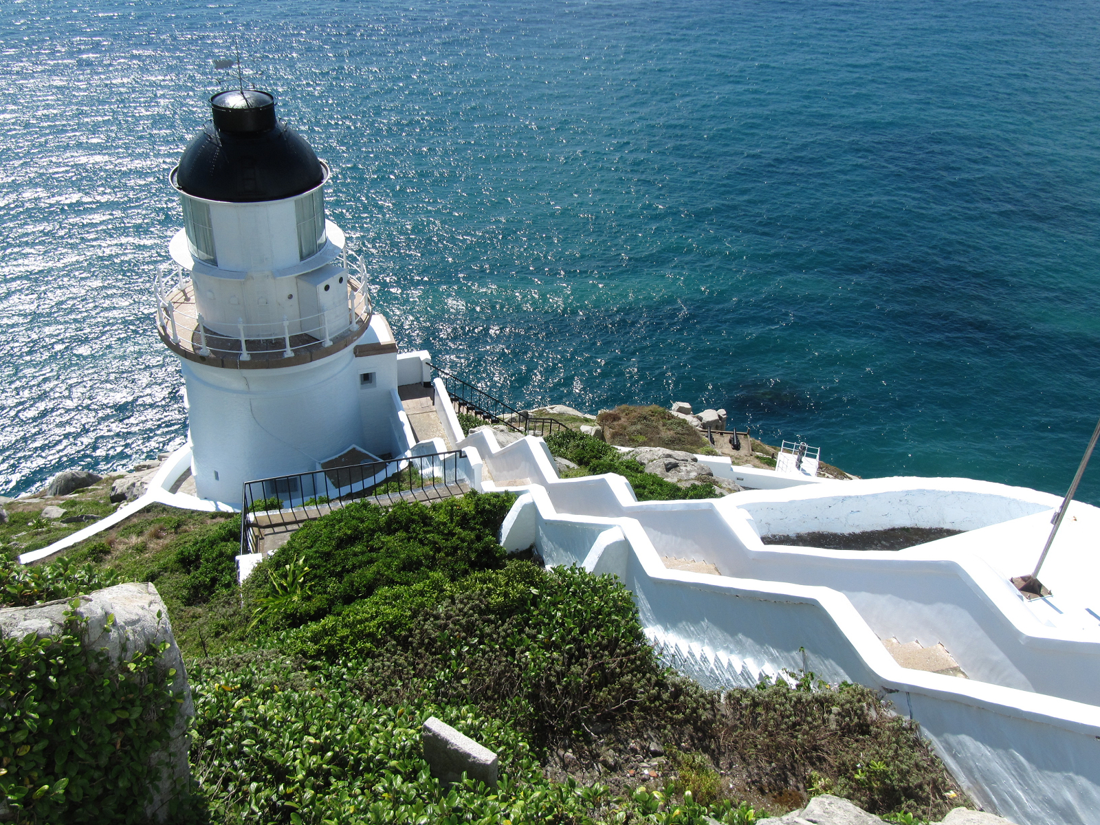
During the early Qing Dynasty, pirates gathered here and the residents left temporarily. In contrast with Taiwan and Penghu, the Matsu Islands were not ceded to the Japanese Empire via the Treaty of Shimonoseki in 1895. Due to its strategic location along the only route for the spice traffic, the British established the Dongyong Lighthouse in Dongyin Island in 1912 to facilitate ships navigation.[23]
Republic of China
In 1911, the Qing Dynasty was toppled after the Xinhai Revolution on 10 October 1911 and the Republic of China (ROC) was established on 1 January 1912. Matsu Islands were subsequently governed under the administration of Fukien Province of the ROC. On 1 August 1927, the Nanchang Uprising broke out between the ruling Nationalist Party of China (KMT) and Chinese Communist Party (CCP) which marked the beginning of Chinese Civil War.
On 10 September 1937, Japan occupied Beigan and Nangan via the Collaborationist Chinese Army, making the islands the first in Fujian to fall to Japan.[24][25] The islands were not occupied by Japanese troops during World War II because they were not important militarily. The Surrender of Japan took place on August 15, 1945.
As a result of the Chinese Civil War, in 1949 the Chinese Communist Party (CCP) took over mainland China from the Chinese Nationalist Party (Kuomintang, KMT). The CCP established the People's Republic of China (PRC) on 1 October 1949, which included administration of today's Lianjiang County of Fujian. The KMT retreated from mainland China to Taiwan at the end of 1949, but retained some of the offshore parts of Lienchiang County (namely, the Matsu Islands), and also most of Kinmen County (Quemoy). On 15 December 1950, the Matsu Administrative Office (馬祖行政公署) of Fujian Province, Republic of China, was established, including modern-day Lienchiang County (the Matsu Islands), as well as islands in present-day Haidao Township, Xiapu County and Taishan (台山) in present-day Shacheng, Fuding, Ningde, Fujian, China (PRC)[26][27] which were attacked in 1950 and 1951.[28]
In early July 1953, Chinese Nationalist guerillas retreated from islands in the Xiyang Island (Chihchutao) area of present-day Haidao Township (PRC), and the area came under the control of the PRC.[29] In June 1955, the PRC undertook considerable road and military construction around Haitan Island, Pingtan County, Fuzhou, Fujian, China, including roads leading to possible artillery positions on the mainland. Those positions might have been used to protect the Haitan Strait, which was considered a favorable staging area for amphibious operations against the Matsu Islands.[30] In July 1958, the PRC began massing forces opposite Kinmen (Quemoy) and Matsu (Lienchiang) and began bombarding them on 23 August, triggering the Second Taiwan Strait Crisis. On 4 September 1958, the PRC announced the extension of its territorial waters by 20 kilometres (12 mi) to include the two islands. However, later that month, after talks between the USA and PRC in Warsaw, Poland, a ceasefire was agreed and the status quo reaffirmed.[31]
The phrase "Quemoy and Matsu" became part of American political language in the 1960 U.S. presidential election. During the debates, both candidates, Vice-President Richard Nixon and Senator John F. Kennedy, pledged to use American forces if necessary to protect Taiwan from invasion by the PRC, which the United States did not recognize as the legitimate government of China. However, in the second debate on 7 October 1960, the two candidates stated different opinions about whether American forces should also be used to protect Taiwan's forward positions, Quemoy and Matsu.[32] Senator Kennedy stated that these islands—as little as 9 kilometres (5.5 mi) off the coast of China and as much as 170 kilometres (106 mi) from Taiwan—were strategically indefensible and were not essential to the defense of Taiwan. Vice-President Nixon maintained that since Quemoy and Matsu were in the "area of freedom", they should not, as a matter of principle, be surrendered to the Communists.[33]
Earlier in the debate, Nixon said:
In the Truman Administration 600 million people went behind the Iron Curtain including the satellite countries of Eastern Europe and Communist China. In this Administration we have stopped them at Quemoy and Matsu, we have stopped them in Indo China, we have stopped them in Lebanon, we have stopped them in other parts of the world.
Later in the debate, Edward P. Morgan asked Senator Kennedy:[34][35][36][37][38]
Senator, Saturday on television, you said that you had always thought that Quemoy and Matsu were unwise places to draw our defense line in the Far East. Would you comment further on that, and also address to this question: couldn't a pull-back from those islands be interpreted as appeasement?

"The Nationalist-held islands off the Chinese mainland are nominally a part of Fukien Province, but are presently under military administration." (1962)
Kennedy's response was:
Well, the United States has on occasion attempted, mostly in the middle '50s to persuade Chiang Kai-shek to pull his troops back to Formosa. I believe strongly in the defense of Formosa. These islands are a few miles, five or six miles[lower-alpha 1] off the coast of Red China within a general harbor area, and more than a hundred miles[lower-alpha 2] from Formosa. We have never said flatly that we will defend Quemoy and Matsu if it is attacked. We say we will defend it if it's part of a general attack on Formosa, but it is extremely difficult to make that judgment.
Now, Mr. Herter, in 1958, when he was Under Secretary of State, said they were strategically indefensible. Admiral Spruance and Collins in 1955 said that we should not attempt to defend these islands in their conference on the Far East. General Ridgway has said the same thing. I believe that when you get into a war, if you're going to get into a war for the defense of Formosa, it ought to be on a clearly defined line. One of the problems, I think, at the time of South Korea was the question of whether the United States would defend it if it were attacked. I believe that we should defend Formosa, we should come to its defense. It leaves this rather in the air that we will defend it under some conditions but not under others, I think it is a mistake.
Secondly, I would not suggest a withdrawal at the point of the Communist guns. It is a decision finally that the Nationalists should make and I believe that we should consult with them and attempt to work out a plan by which the line is drawn at the Island of Formosa. It leaves 100 miles[lower-alpha 3] between the sea. But with General Ridgway, Mr. Herter, General Collins, Admiral Spruance and many others, I think it is unwise to take the chance of being dragged into a war which may lead to a world war over two islands which are not strategically defensible, which are not according to their testimony, essential to the defense of Formosa.
I think that we should protect our commitments. I believe strongly we should do so in Berlin. I believe strongly we should do so in Formosa and I believe we should meet our commitments to every country whose security we've guaranteed. But I do not believe that that line, in case of a war, should be drawn on those islands, but instead on the island of Formosa. And as long as they are not essential to the defense of Formosa, it has been my judgement ever since 1954, at the time of the Eisenhower Doctrine for the Far East, that our line should be drawn in the sea around the island itself.
Vice President Nixon retorted:
I disagree completely with Senator Kennedy on this point.
I remember in the period immediately before the Korean War, South Korea was supposed to be indefensible as well. Generals testified to that, and Secretary Acheson made a very famous speech at the Press Club early in the year that the Korean War started, indicating in effect that South Korea was beyond the defense zone of the United States. I suppose it was hoped when he made that speech that we wouldn't get into a war, but it didn't mean that. We had to go in when they came in.
Now I think as far as Quemoy and Matsu are concerned, that the question is not these two little pieces of real estate- they are unimportant. It isn't the few people who live on them- they are not too important. It's the principle involved. These two islands are in the area of freedom. The Nationalists have these two islands. We should not force our Nationalist allies to get off of them and give them to the Communists. If we do that, we start a chain reaction, because the Communists aren't after Quemoy and Matsu, they're after Formosa. In my opinion, this is the same kind of woolly thinking that led to disaster for America in Korea, I'm against it, I would never tolerate it as President of the United States, and I will hope that Senator Kennedy will change his mind if he should be elected.

After the third debate on 13 October 1960, Kennedy's advisers spoke with then Secretary of State Herter and said Kennedy was willing to revise his position on the Quemoy and Matsu issue so as not to give the Communists the impression that the USA would not stand united against aggression. Nixon pointed out the change in Kennedy's position but decided not to press the point due to the importance of the USA's role in what was an extremely tense situation.[39] Polls of Republicans and Democrats showed overwhelming support for Nixon's position.[40]
Self-governance of the county resumed in 1992, after the cessation of political warfare with the mainland and the abolition of Battle Field Administration on 7 November 1992.[41] Afterwards, local construction picked up pace. In 1999, the islands were designated as the Matsu National Scenic Area Administration.[23][42] In January 2001, direct cargo and passenger shipping started between Matsu and Fujian Province of the PRC.[43] After 1 January 2015, tourists from mainland China could directly apply the Exit and Entry Permit upon arrival in Matsu Islands. That privilege also applied to Penghu and Kinmen, as a means to boost tourism in the outlying islands of Taiwan.[44] In December 2015, the Huangqi-Matsu ship route was introduced as part of the Mini Three Links.[45][46]
In 2020, rampant illegal sand mining by Chinese ships in the waters around the Matsu Islands[47] caused concern in the islands and in the Executive Yuan about damage to the marine environment, possible damage to underwater telecommunications cables, and the potential for coastal erosion. Auctioning impounded ships was seen as an easy way for the dredging companies to get their ships back via intermediaries, hence sinking the impounded ships was under consideration.[48]
Geography

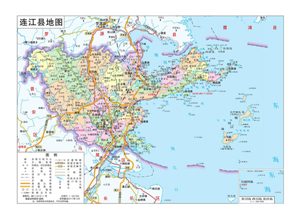
The Matsu Islands comprise 19 islands and islets,[49] which include five major islands, which are Nangan, Dongju and Xiju (both in Juguang Township), Beigan and Dongyin.[19] Minor islands include Liang Island, Gaodeng Island, Daqiu Island and Xiaoqiu, which are part of Beigan Township.[50] The shortest distance between Huangqi, Lianjiang County and the Matsu Islands is also the shortest distance between China (PRC) administered territory and territory in the ROC (Taiwan)-administered Matsu Islands.[51][52]
Dongyin is the northernmost and Dongju is the southernmost.
- Dongyin is 100 nautical miles (190 km) from Keelung, Taiwan, 180 to the Penghu islands, and slightly over 10 nautical miles (19 km) from Mainland China.
- The soil is not ideal for farming.
- The highest point is on Beigan, 298 metres (978').
Areas:
- Nangan: 10.43 km2 (4.03 sq mi)
- Beigan: 8.86 km2 (3.42 sq mi)
- Dongyin: 4.35 km2 (1.68 sq mi)
- Juguang islands: see Juguang
Geology
The islands are predominantly composed of Jurassic and Cretaceous intrusive (emplaced ~160 Ma, ∼130 Ma and ∼94 Ma) granite and diabase.[53]
Climate
Average annual temperature is 18.6 °C (65°F), with the average low being at 13 °C (55°F) and average high at 29 °C (85°F). The daily temperature varies greatly during day and night. The region experiences subtropical maritime climate, which is influenced by monsoon and ocean currents and its geographic location. Matsu has four seasons: during winter it is cold and wet, during summer and spring it is foggy, and during autumn the weather is generally stable.[54][55]
Politics and government


Matsu Islands are administered as Lienchiang County under the Fujian Provincial Government. Nangan Township is the county seat which houses the Lienchiang County Government and Lienchiang County Council. The county is headed by a magistrate, elected every four years in the ROC local elections. The incumbent magistrate is Liu Cheng-ying of Kuomintang.
Administrative divisions
Lienchiang County is divided into four rural townships.[56] It is further divided into 22 villages and 137 neighborhoods (鄰). Lienchiang County is the only county in Taiwan which does not have a city or an urban township. The county seat is Nangan Township (Nankan).
| Name | Chinese | Wade–Giles | Pinyin | Foochow Romanized |
|---|---|---|---|---|
| Rural townships | ||||
| Beigan Township | 北竿鄉 | Pei³-kan¹ Hsiang¹ | Běigān Xiāng | Báe̤k-găng Hiŏng |
| Dongyin Township | 東引鄉 | Tung¹-yin³ Hsiang¹ | Dōngyǐn Xiāng | Dĕ̤ng-īng Hiŏng |
| Juguang Township | 莒光鄉 | Chü³-kuang¹ Hsiang¹ | Jǔguāng Xiāng | Gṳ̄-guŏng Hiŏng |
| Nangan Township | 南竿鄉 | Nan²-kan¹ Hsiang¹ | Nángān Xiāng | Nàng-găng Hiŏng |
All the townships administer more than one island.
Magistrates
Before 1993, county magistrates were appointed.
- Elected magistrates
- Tsao Chang-Shun (曹常順) (1993-1997) (KMT)
- Liu Li-Chun (劉立群) (1997-2001) (KMT)
- Chen Hsueh-sheng, also the current national representative of Matsu. (2001-2009) (PFP, later KMT)
- Yang Sui-sheng (2009-2014) (KMT)
- Liu Cheng-ying (2014-present) (KMT)
Military
The Matsu Islands are protected by the ROC Army Matsu Defense Command (陸軍馬祖防衛指揮部).
Politics
Lienchang County voted one Kuomintang legislator out of one seat to be in the Legislative Yuan during the 2016 Republic of China legislative election.[57] While the Democratic Progressive Party have had difficulty winning a county-level election in this area, most of the competitions are among local strategies. In 2018, a Green Party member, 蘇柏豪 attempted to run for magistrate but failed.
Cross-Strait relations
The historical Lienchiang County roughly included the northern three townships of today's Matsu Islands (Lienchiang County) and the area of today's Lianjiang County of the People's Republic of China (PRC).[citation needed] The PRC claims the three northern townships of the Matsu Islands as Matsu Township (馬祖鄉; Mǎzǔ Xiāng; Mā-cū hiŏng)[58][59][60][61] and the Juguang Islands (the southernmost islands, formerly named the Baiquan Islands) as part of Changle District.[58][62]
Vessels from the Taiwan's Coast Guard Administration (CGA) have confronted sand dredging by Chinese vessels near the Matsu Islands.[63] This dredging activity began in 2018.[63] Since March 2019, the Lienchiang Cross-Strait Matters Forum started as an official forum between Lienchiang County of the Republic of China (Taiwan) and Lianjiang County of the People's Republic of China to discuss matters regarding the two sides.[64]
Demographics and culture

Population
The majority of native Matsu Islands residents originated from Northern Fujian. Several of the islands of Matsu are not inhabited permanently. Some of these are garrisoned by soldiers from the Republic of China Armed Forces stationed in the county since the end of the Chinese Civil War in 1949 and during the First and Second Taiwan Strait Crisis in 1954 and 1958 respectively. Due to that high military demand large numbers of military personnel stationed on the islands produced unprecedented population growth in the county. The population reached its peak in 1971 with a total of 17,088 people. After those periods of high growth the population decreased year after year due to the poor economic growth which resulted in mass youth emigration due to lack of employment opportunities. In recent years the population in the county has gradually increased because of immigration. The population has stabilized due to the improved transportation between Taiwan Island and Matsu Islands as well as mass construction projects.[23]
Languages
The native language spoken by Matsu residents is Matsu dialect, a subdialect of Fuzhou dialect, which is one of the statutory languages for public transport announcements in the Matsu Islands.[65][49] Mandarin Chinese is one of the official languages of Lienchiang County.
Name
Chen (陳) is the most common surname, then Lin (林), Wang (王), Tsao (曹) and Liu (劉).
Belief
Matsu, though named after the goddess Matsu, is written with a different character that has a different tone. But the Matsu Islands are not the birthplace of the goddess as the human Lin Muoniang - Meizhou Island is — but her death place (on a seaport named after her on Nangan Island).[66]
The Matsu Nangan Tianhou Temple (馬祖南竿天后宮), a temple dedicated to the goddess, contains the sarcophagus of Lin Muoniang. It is, however, not as popular as the Meizhou temple.
Most Taiwanese pilgrims to Meizhou start off their journey in the Matsu Islands because they are the closest ROC-controlled territory to Meizhou, which is controlled by the PRC.
Economy

Due to its geographically remote location, the manufacturing business of Matsu has never been fully developed. Among them, the wine making industry of Matsu Distillery is the most distinguished feature. Tourism has become a highly important feature of the economy.[67]
However, most of its commercial trading focuses on retail businesses and restaurants for stationed military consumption. Farm products of Matsu include rice, sugar cane, tea plant, oranges. Sea animals, such as fish, clams, and jellyfish, are also popular exports due to its nature as the major traditional industry in Matsu. However, the flourishing fishing ground is almost exhausted by arbitrary fish bombing by Mainland China fishing boats, while the fish population is decreasing as well.[23]
In July 2012, Matsu residents voted in favor of the establishment of casinos, which led to the prospect of gaming industries in the county and the passing of the Gaming Act (Chinese: 觀光賭場管理條例).[68]
Energy and environment

Power generation
On 1 July 1975, the Matsu Power Company was founded to operate all of the power plants in the county. On 1 July 1986, the company was incorporated into Taiwan Power Company.[69] The county is powered up by its fuel-fired (diesel) Zhushan Power Plant located in Cingshuei Village of Nangan Township with a capacity of 15.4 MW commissioned on 22 March 2010. The other power plants are Beigan Power Plant in Beigan Township, Dongyin Power Plant in Dongyin Township and Dongju Power Plant in Dongju Island and Xiju Power Plant in Xiju Island of Juguang Township. The county is also powered up by its photovoltaic system with a capacity of 0.074 MW.[70]
Pollution
Generally, the environment of Matsu Islands is still well-preserved. The major source of pollution is from family and military household waste. There are, however, concerns that the continued lack of modern sewage facilities results in household waste seeping into groundwater.[23]
Tourism

Tourism has become a critical sector in the local economy.[67] Lienchiang County Government is making an effort to attract more visitors to the Matsu Islands, especially among foreigners.[71][72] Dongyin Visitor Center is the main visitor center of the township.
Nangan is the capital of Matsu and it is noted for its granite tunnel and the Iron Fort. It has two interconnected main roads.
The Beihai Tunnels are manmade granite tunnels. Both tunnels were remarkable for their time, and they took great effort to construct. The tunnel in Nangan was built in 1968. The completion of Beihai Tunnel took the effort of thousands of men. The 700 metre (800 yard) tunnel has a width of 10 metres (33') and a height of 16 metres (52'). It was completed in 820 days with shovels, spades and explosives; the tunnel also took the life of a platoon of soldiers. The tunnel was considered a military location and was not opened to the public until 1990.
The Iron Fort is located on the Southwest side of Nangan island. Located by a small cliff, it is a vulnerable spot for outside attacks or illegal smuggling of materials. With that in mind, the fort was built for defence. It is equipped with multiple machinegun rooms and rudimentary living facilities. It is now open to the public, and although most of the equipment has been removed from the site, the site itself brings back a vivid image of what it was like for soldiers at that time.
Museums in Matsu including the Matsu Blue Tears Ecological Museum, Matsu Folk Culture Museum, Ching-kuo Memorial Hall and War and Peace Memorial Park Exhibition Center.
Nature
Since 1990, the county manages the Matsu Islands Bird Sanctuary, which spreads across eight islands and islets in Nangan, Beigan and Tongyin Townships. It contains 30 species in 15 orders, mostly gulls and terns. In 2000, four pairs of the critically endangered Chinese crested tern, previously thought to be extinct, were discovered nesting on the Matsu Islands, giving them global conservation importance.
There are also mosses and ferns rare or absent elsewhere in the ROC.[73]
Cetacean species that have become rare along Chinese coasts are still present here such as false killer whales and finless porpoises,[74] providing opportunistic observations at times.[75] Finless porpoises in this areas are generally smaller than other subspecies,[76] and it is unique that two subspecies inhabit in this region where Matsu region is the northern limit for one of them.
Transportation

Air
Both Nangan and Beigan have airports which are the Matsu Nangan Airport and Matsu Beigan Airport respectively. Dongyin and Juguang (in Xiju Island) house heliports which only operate during winter time and priority is given to local residents to travel to Nangan.[77]
Sea
Due to the main airport being located in Nangan, boats are the main form of transportation between the islands in the county.
There are two ferry rides to Mainland China. One arrives at Mawei District of Fuzhou and departs from Fuao Harbor at Nangan Township in which the journey normally takes 90 minutes while in Nangan.[78] Another arrives at Huangqi (黄岐镇) of Lianjiang and departs from Beigan Township in which the journey takes only 20 minutes.[79] Dongyin Township houses the Zhongzhu Harbor.
Road
Due to their size, travelling by motorized scooter is an ideal way to get around the main islands such as Nangan and Beigan, despite the steep hills. Both Islands have regular buses and taxis are also economical. In October 2019, Mainland China announced 'initial plans' to build a bridge linking Fuzhou to the Matsu Islands. Taiwan's Mainland Affairs Council (MAC) said that the plans were made unilaterally by Mainland's Fujian as part of its schemes to absorb Taiwan and divide Taiwanese society and that they see no need for bridges linking either Matsu or Kinmen to Mainland China.[80]
Notable persons
- Chen Pao-yu, Chief of Staff of the Republic of China Army (2019-)
See also
- Matsu Daily
- Lianjiang County(located in mainland China)
- Administrative divisions of the Republic of China
- List of Taiwanese superlatives
- List of cities in the Republic of China
- List of islands of the Republic of China
Notes
- Gaodeng Island is 5.75 miles from the Beijiao Peninsula. In Kinmen County, the northern coast of Greater Kinmen (Quemoy) is about five or six miles from the nearest point on mainland Asia in places. Some ROC-controlled areas are closer than five miles from PRC-controlled areas. For instance, Jiaoyu in Dadeng Subdistrict is a little more than one mile from the tip of Greater Kinmen in Jinsha Township.
- Juguang, Lienchiang and Dongyin, Lienchiang are a little more than ninety miles from the closest point on the main island of Taiwan (Formosa), and Wuqiu, Kinmen is about eighty miles from the closest point. The main islands Nangan (Matsu) and Greater Kinmen (Quemoy) are over one hundred miles from Taiwan Island.
- The island of Taiwan is separated from the southeast coast of China by the Taiwan Strait, which ranges from 220 km (140 mi) at its widest point to 130 km (81 mi) at its narrowest.
References
- 生態環境. 馬祖-連江縣政府 LIENCHIANG COUNTY GOVERNMENT (in Chinese (Taiwan)). 9 January 2017. Retrieved 22 August 2019.
終於讓專家學者在經過2年研究後,發現了全新品種的雌光螢,命名為北竿雌光螢和分布於東莒島的黃緣雌光螢,這對於總面積僅29.6平方公里的馬祖來說,是極為珍貴的物產。
- 城市介紹. Matsu Health Bureau Web site 連江縣衛生福利局 (in Chinese (Taiwan)). Retrieved 23 August 2020.
列島的陸域面積為29.60平方公里,全縣各島海岸線總長為 133 公里
- 截至106年6月底 馬祖總人口數12716人. Matsu Daily (in Chinese (Taiwan)). 14 July 2016. Retrieved 8 September 2019.
總計:2768戶,12716人,男性7244人,女性5472人。
- Longman, J.C. (2008). Longman Pronunciation Dictionary (3 ed.). Pearson Education ESL. ISBN 978-1405881173.
- "Lienchiang County". Lienchiang County. Retrieved 22 August 2019.
Address:No.76, Jieshou Village, Nangan Township, Lienchiang County 209, Taiwan (R.O.C.) {...} Lienchiang County Copyright ©2016 Lienchiang County Government.
- 臺灣地區鄉鎮市區級以上行政區域名稱中英對照表 (PDF) (in Chinese (Taiwan) and English). Online Translation System of Geographic Name, Ministry of Interior. 16 June 2011. p. 14. Archived from the original (PDF) on 25 March 2012.
縣市鄉鎮區別 國際慣用名 漢語拼音譯寫 備註{...}連江縣 Lienchiang County Lianjiang County直轄市、縣(市)級以上行政區域名稱係依國際慣用方式譯寫
- "Local governments". Office of the President, Republic of China (Taiwan). Archived from the original on 6 September 2020. Retrieved 11 October 2020.
Lienchiang{...}Lienchiang County
- "Matsu Island". Encyclopædia Britannica Online. Archived from the original on 4 November 2019. Retrieved 12 October 2020.
Matsu is the main island of a group of 19, the Matsu Islands, which constitute Lien-kiang (Lienchiang) hsien (county).
- "Country Profile: Taiwan" (PDF). Federal Research Division, Library of Congress. March 2005. p. 20. Archived (PDF) from the original on 15 February 2017. Retrieved 12 October 2020.
- Index to the Postal Working Map. Shanghai: Inspectorate General of Customs. 1904. pp. 41, 87 – via Internet Archive.
Lienchiang-hs. 連江縣
- A Gazetteer of Chinese Geographical Names. 1938. pp. 156, 158 – via Internet Archive.
Lienkong-hsien 連江縣 福建省東部福州の東北 (Lienchiang){...}Limkong-hsien 廉江縣(石城) 廣東省西南部廣東灣の北方 (Lienchiang)
- "Chinese Communist Highway Construction and Repair". CIA. 2 November 1953. p. 2. Retrieved 22 August 2019 – via Internet Archive.
4. On 1 June the construction of a highway from Foochow to Loyuan (N 26-30, E 119-32) via Mawei (N 26-00, E 119-26) and Lienchiang (N 26-12, E 119-31) was scheduled to begin.
- "Current Intelligence Bulletin". CIA. 7 February 1956. p. 4. Retrieved 22 August 2019 – via Internet Archive.
Lienchiang
- "Topography of Fukien; situation and boundaries of the province; its area and population; subdivisions, mountains, rivers, harbors &c". The Chinese Repository. 11 (12): 652. December 1842 – via Internet Archive.
6 連江 Lienkiáng
- A Pictorial History of the Republic of China : Its Founding and Development. Vol. 2. Taipei: Modern China Press. 1981. p. 528 – via Internet Archive.
Outlying the island of Kinmen, the Matsu Islands are well known to the world because of its valiant defense. These consist of Kaoteng, Peikan, Nankan, Tungchuan and Sichuan and spread out at the mouth of the Min River. They form a part of Lienkiang county, Fukien.
- Gwillim Law (1999). Administrative Subdivisions of Countries : A Comprehensive World Reference, 1900 through 1998. McFarland & Company. p. 357 – via Internet Archive.
The other is Lienkiang (islands of Matsu, Changhsu Chan, Tungyin Tao, Tungchuan Tao).
- "About Matsu". Lienchiang County. Archived from the original on 21 August 2019. Retrieved 22 August 2019.
Matsu islands
- "History and Customs". Matsu National Scenic Area. 19 January 2019. Archived from the original on 12 September 2018. Retrieved 22 August 2019.
The oldest traces of settlements in the Matsu Islands were on the island of Dongju, and have been determined to be relics from the Neolithic era.
- "FOREIGN RELATIONS OF THE UNITED STATES, 1955–1957, CHINA". Office of the Historian, US Department of State. Washington, D.C. 16 March 1955. Archived from the original on 4 August 2020. Retrieved 28 August 2019.
158. National Intelligence Estimate{...}3.In the context of this estimate the term "Matsu Group" or "Matsus" denotes those Chinese Nationalist-held islands lying essentially between 25 and 27 degrees north latitude and consisting of Tung-yin Shan, Lang Tao, Kao-teng Hsu, Pei-kan Tang, Matsu Shan, Pai-chuan and Lieh Tao [sic] (White Dogs), Wu-chiu, and Hsia Wu-chiu. "Matsu" used singly applies only to Matsu-Shan proper.
- Hu Meidong, Lin Shujuan (26 December 2015). "Further options open for Straits travel". China Daily. Archived from the original on 8 October 2020. Retrieved 16 March 2020.
A passenger ferry route between Huangqi in Fujian province and Matsu has allowed tourists and commuters a cheaper and faster choice for cross-Straits travel. Huangqi, a port under the administration of the capital Fuzhou, is the closest mainland port to Matsu, which has also been connected with Mawei port in Fuzhou since 2001. A direct passenger ferry trip along the latter route takes around 90 minutes. Each trip along the Huangqi-Matsu route, which crosses an 8-kilometer strip of sea, takes 25 minutes and costs 135 yuan ($21). "The Huangqi-Matsu route has made daily commuting between Lianjiang and Matsu much easier," said Yang Wenjian, head of Lianjiang-Matsu Cultural Research Society, an NGO dedicated to promoting civil exchanges between the two places.
{{cite web}}: CS1 maint: uses authors parameter (link) - 「馬祖」地名由來(連江縣志續修-地理志初稿).
- Sandy Huang (April 6, 2003). "Cases of mistaken identity perplexing Lienchiang County". Taipei Times. Archived from the original on March 16, 2009. Retrieved January 14, 2009.
- "福建省政府". Archived from the original on 2015-09-24. Retrieved 2014-09-04.
- 北竿鄉志 大事記(民國十七年至四十九年) [History of Beigan Major Events (1928-1960)]. 馬祖資訊網 (in Chinese (Taiwan)). Retrieved 2 September 2019.
二十六年
九月十日
北竿、南竿被日軍侵占,成為福建最早淪陷的島嶼。 - 林金炎 (15 September 2014). 馬祖歲月印記 (in Chinese (Taiwan)). p. 46. ISBN 978-986-90943-0-6.
0910 日軍透過偽軍侵佔馬祖列島的南、北竿島,成為福建最早淪陷的島嶼。《連江縣志,大事紀P.34,連江縣地方志編纂委員會,2000.6,方志出版社。》
- 林金炎 (24 June 2011). 馬祖紀事-1950 /林金炎 (in Chinese (Taiwan)). Retrieved 21 February 2020.
12月15日、福建省政府成立「馬祖行政公署」,行政區以島為單位,改設馬祖為八區,即「南竿」、「北竿」、「白肯」、「東湧」、「四礵」、「岱山(台山)」、「西洋」、「浮鷹」區,
- 請問:連江縣政府的沿革. 馬祖資訊網 (in Chinese (Taiwan)). 25 June 2008. Retrieved 22 February 2020.
鄉政沿革
39年12月15日,「馬祖行政公署」成立於南竿,將原設之區署及鄉公所撤銷,行政區域改以島為單位,改設南竿、北竿、白肯、東湧、四霜、西洋、浮鷹、岱山等8區,各區設區公所,區下設村、伍,為地方基層行政組織。 - 林金炎, ed. (2006). 莒光鄉志 [The Biography of Jyuguang Township] (in Chinese (Taiwan)). p. 460-61. ISBN 986-00-5026-0.
- "Chinese Communist Treatment of Coastal Islanders, Fukien". CIA. 16 September 1953. pp. 1–2. Retrieved 21 February 2020 – via Internet Archive.
[Sanitized] Comment. The Chinese Nationalist guerrillas withdrew from islands in the Chihchutao area in early July [sanitized] and are now concentrated on Yinshan (N 26-22, E 120-30). Chihchutao, Shuangfengtao, Machick, and Chuishan are now Chinese Communist controlled although not occupied by troops. The Nationalist have lost control over these islands and it is extremely difficult for them to return to the area.
- "Current Intelligence Weekly Summary". CIA. 30 June 1955. p. 2 – via Internet Archive.
- A Study of Crisis, Michael Brecher, 1997, p. 385
- Robert B. Norris (November 2010). "A Historical Footnote Revisited". UNC-CH. Retrieved 4 October 2020.
- Norris, Robert B. (November 29, 2010). "Quemoy and Matsu: a historical footnote revisited". American Diplomacy. Archived from the original on 20 October 2018. Retrieved 2014-04-01.
- OCTOBER 7, 1960 Presidential Candidates Debate. Event occurs at 52:34. Archived from the original on April 16, 2019. Retrieved December 7, 2019 – via C-SPAN.
- "TELEVISION DEBATES: TRANSCRIPT: SECOND DEBATE". John F. Kennedy Presidential Library and Museum. pp. 53, 58–61. Archived from the original on 2019-08-21. Retrieved 2019-08-21.
- The Joint Appearances of Senator John F. Kennedy and Vice President Richard M. Nixon and Other 1960 Campaign Presentations. US Government Printing Office. 1961. p. 163 – via Google Books.
- Chris Matthews (October 2013). Chris Matthews Complete Library. p. . ISBN 9781476764696.
- "Presidential Debate in Washington, DC". October 7, 1960. Retrieved 4 October 2020.
- Richard Nixon (1978). RN: The Memoirs of Richard Nixon. Simon & Schuster. p. 272. ISBN 0-446-93259-0 – via Internet Archive.
Once again I hit hard on the Quemoy-Matsu issue, stating that Kennedy's willingness to surrender the islands to the Communists under threat of war was no different from submitting to blackmail. Shortly after the third debate I learned that one of Kennedy's top foreign policy advisers had telephoned Secretary of State Herter to say that Kennedy did not want to give the Communists the impression that America would not stand united against aggression and was therefore prepared to revise his position in order not to appear to oppose the administration on this issue. I saw this as Kennedy's way of trying to slide away from an unpopular position, and my immediate inclination was not to let him get away with it. But the Quemoy-Matsu situation was so tense, and the importance of America's role in discouraging Communist aggression was so great, that I decided not to press the point if Kennedy modified his stand. I pointed out how his changed attitude reflected his lack of experience, and then let the issue drop.
- Victor Lasky (1963). J.F.K. : the man and the myth. p. 444 – via Internet Archive.
- "Lienchiang County Council - Introduction to Matsu". mtcc.gov.tw. Archived from the original on 2015-03-25. Retrieved 2015-10-20.
- "Matsu tourism heralds new dawn for Lienchiang County - Taiwan Today". Archived from the original on 2015-12-08. Retrieved 2015-12-04.
- "Headline_Taiwan Affairs Office of the State Council PRC". Archived from the original on 2014-07-14. Retrieved 2014-07-04.
- "Annual ridership on Kinmen-Fujian ferry services tops 1.5 million". Archived from the original on 2014-12-31. Retrieved 2015-01-02.
- Chen Chien-Yu 陳建瑜 (24 December 2015). 北竿到黃岐 小三通再添新航線. China Times (in Chinese (Taiwan)). Retrieved 19 March 2020.
- "Huangqi-Matsu route sees increasing traffic". China Daily. 16 December 2019. Retrieved 19 March 2020.
the Huangqi-Matsu ship route{...}was first introduced in December 2015,{...}The Huangqi-Matsu ship route, the fastest route between the mainland and Matsu, is one of Fujian province's four "Mini Three Links",
- "Taiwan coastguard 'drives away' Chinese vessels including sand dredger". sg.news.yahoo.com. Retrieved 2021-01-14.
- Wen Lii (12 August 2020). "From Taiwan to the Philippines, Chinese Illegal Dredging Ships Wreak Environmental Havoc". The Diplomat. Retrieved 23 August 2020.
- "The Matsu Islands". Archived from the original on 2015-01-02. Retrieved 2014-09-09.
- 連江縣土地段名代碼表 (in Chinese (Taiwan)). Department of Land Administration. 16 May 2012. Retrieved 27 August 2019.
地政事務所名稱(代碼) 連江(ZA) 鄉鎮市區名稱(代碼) 北竿鄉(02) 段 小段 代碼 備註{...}大坵 0020 無名島 0021 高登 0022 峭頭 0023 進嶼 0024 亮島 0035 調整 浪岩 0036 調整 三連嶼 0039 中島 0040 調整 白廟 0041 調整 老鼠 0042 調整
- 黄岐镇 [Huangqi Town]. 福州市连江县政府 (in Simplified Chinese). 13 June 2019. Archived from the original on 4 August 2020. Retrieved 18 March 2020.
对台优势。黄岐镇与马祖列岛一衣带水,两岸最近处仅距离8000米,素有"里山"、"外山"之称,是祖国大陆离马祖最近的地方,也是环马祖澳旅游区的核心区域。
- 黄岐镇 [Huangqi Town] (in Simplified Chinese). XZQH.org. 13 November 2008. Retrieved 18 March 2020.
南与马祖列岛隔海相望(两岸最近处仅距离8000米,是祖国大陆离马祖岛最近的地区),
- Chen, Jing-Yuan; Yang, Jin-Hui; Ji, Wei-Qiang (December 2017). "Ages and petrogenesis of Jurassic and Cretaceous intrusive rocks in the Matsu Islands: Implications for lower crust modification beneath southeastern China". Journal of Asian Earth Sciences. 150: 14–24. Bibcode:2017JAESc.150...14C. doi:10.1016/j.jseaes.2017.10.004.
- "Climate, Flora and Fauna - Matsu National Scenic Area". Archived from the original on 2014-08-13. Retrieved 2014-09-10.
- "Introduction to Matsu". Archived from the original on 2013-06-02. Retrieved 2014-08-24.
- 臺灣地區鄉鎮市區級以上行政區域名稱中英對照表 (PDF). Online Translation System of Geographic Name, Ministry of Interior. 16 June 2011. p. 14. Archived from the original (PDF) on 25 March 2012.
- "2016 the 14th Presidential and Vice Presidential Election and the 9th Legislator Election". Archived from the original on 2016-03-04. Retrieved 2016-01-17.
- 连江县地图 (Map). People's Government of Lianjiang County, Fuzhou City 福州市连江县人民政府 (in Simplified Chinese). Archived from the original on 11 October 2020. Retrieved 11 October 2020. (Note: In the map, the northern three townships of Lienchiang County, ROC (Taiwan) are explicitly included within the boundaries of Lianjiang County, PRC (mainland China) while the southernmost township of Lienchiang County, ROC (Taiwan) is explicitly not included within the boudaries of Lianjiang County, PRC (mainland China).)
- 2018年统计用区划代码和城乡划分代码:连江县 [2018 Statistical Area Numbers and Rural-Urban Area Numbers: Lianjiang County] (in Simplified Chinese). National Bureau of Statistics of the People's Republic of China. 2018. Retrieved 22 August 2019.
统计用区划代码 名称{...}350122400000 马祖乡
- 境域面积. 福州市连江县政府 (in Simplified Chinese). 10 May 2005. Archived from the original on 22 August 2019. Retrieved 22 August 2019.
全县总面积428平方公里(包括待统一的马祖列岛)。
- 连江县历史沿革 [Lianjiang County Historical Development] (in Simplified Chinese). XZQH.org. 16 June 2015. Retrieved 22 August 2019.
1949年划为敖江、丹阳、东澳、琯头、筱定、黄苔6镇和荷山、浦洋、镜山、荻壶、潘溪、小沧、朱蓼、所南、象厦、官塘、竿塘、西洋12乡,后又并为8个区,31个乡(镇),其中马祖乡尚待统一。{...}2000年第五次人口普查,连江县常住总人口599962人,{...}(不含马祖乡)2003年末,连江县户籍人口61.31万人,其中非农业人口10.63万人。2004年,全县辖22个乡镇(不含马祖乡),268个村(居),总人口62万人。2007年末,连江县总面积1190.7平方千米(含马祖列岛23.5平方千米)。总人口为613354人(不含马祖列岛),其中城镇人口128298人。
- 长乐市人民政府关于印发《长乐市气象灾害防御规划》的通知. 福州市长乐区人民政府 (in Simplified Chinese). 28 March 2012. Archived from the original on 22 August 2019. Retrieved 22 August 2019.
全境陆地面积723平方公里,海岸线长103公里。有大小岛屿30余个,其中以白犬列岛最大。
Translation: "Changle covers an area of 723 sq km, and has 103 km of coastline. Changle includes more than thirty islands of various sizes. Among these, the largest are the Baiquan Islands." - "Chinese sand dredging vessels dispersed near Matsu".
- Feng, Shao-fu; Lim, Emerson (6 March 2019). "Lienchiang Cross-Strait Matters Forum focuses on sea transportation". Focus Taiwan. Archived from the original on 6 March 2019. Retrieved 7 March 2019.
- 大眾運輸工具播音語言平等保障法
- "History and customs". Matsu National Scenic Area. Archived from the original on July 20, 2011. Retrieved February 8, 2011.
- "Taiwan's small islands turn to tourism to stay afloat". www.ft.com. Retrieved 2021-01-14.
{{cite web}}: CS1 maint: url-status (link) - "Matsu votes to allow building of casino". Archived from the original on 2015-01-02. Retrieved 2014-09-17.
- "Hsieh-ho Power Plant - Zhushan Branch Power Plant". Taipower. Retrieved 7 December 2020.
- "Overview of the Development of Renewable Energy". Taipower. Retrieved 31 December 2020.
- "Matsu Island opens doors to tourists". Taiwan Today. March 3, 2010. Archived from the original on October 9, 2011. Retrieved February 8, 2011.
- "Matsu islands aim to attract more overseas tourists". Taipei Times. August 29, 2010. Archived from the original on September 2, 2010. Retrieved February 8, 2011.
- "Climate, Flora and fauna". Matsu National Scenic Area. Archived from the original on July 20, 2011. Retrieved February 8, 2011.
- "A natural aquatic menagerie". Lienchiang County Government. Archived from the original on 2015-01-03. Retrieved 2015-01-03.
- 海洋生态宝库. The Midwest News. 2014. Archived from the original on 2016-11-29. Retrieved 2015-10-13.
- Jefferson A.T., Wang Y.J. (2011). "Revision of the taxonomy of finless porpoises (genus Neophocaena): The existence of two species" (PDF). Journal of Marine Animals and Their Ecology. The Oceanographic Environmental Research Society. 4 (1). Archived from the original (PDF) on 2015-01-03. Retrieved 2015-01-03.
{{cite journal}}: CS1 maint: uses authors parameter (link) - "Island to Island Transport - Matsu National Scenic Area". Archived from the original on 2014-09-11. Retrieved 2014-09-10.
- "Three Mini-Links - Matsu National Scenic Area". Archived from the original on 2015-01-02. Retrieved 2014-09-10.
- "New Matsu-Fujian ferry route to be launched in July: Official - the China Post". Archived from the original on 2015-10-22. Retrieved 2015-10-20.
- Teng, Pei-ju (14 October 2019). "China announces 'initial plans' to build bridges to Taiwan's outlying islands Matsu, Kinmen". Taiwan News. Retrieved 15 October 2019.
A Chinese state-run news channel reported on Sunday (Oct. 13) that Beijing has completed "initial plans" for bridges linking the country to Taiwan’s outlying islands Matsu and Kinmen. Taiwan’s Mainland Affairs Council (MAC) said on Monday that the plans were made unilaterally by China as part of its schemes to absorb Taiwan and divide Taiwanese society, reported Liberty Times. Beijing has long disregarded the existence of Taiwan and shown a lack of respect for its democratic values and system, the MAC said.{...}According to Communist China’s mouthpiece CCTV, a total of 40 experts from both sides of the Taiwan Strait gathered in Fujian’s provincial capital, Fuzhou, on Sunday to discuss plans for the bridges connecting Fuzhou to Matsu and Xiamen to Kinmen.
External links
 Matsu travel guide from Wikivoyage
- Military importance from www.globalsecurity.org
- Smaller map (from CNN)
- Name change: Taipei Times article
- Matzu Scenic Area
- Satellite image of the Nangan and Beigan islands by Google Maps
Administrative divisions of outlying islands of Taiwan | ||
|---|---|---|
| Kaohsiung |
|  |
| Kinmen |
| |
| Lienchiang1 |
| |
| Penghu |
| |
| Pingtung | ||
| Taitung | ||
| Yilan | Toucheng (Guishan Island and Diaoyutai Islands2) | |
1 Lienchiang County commonly known as Matsu. 2Diaoyutai Islands are controlled by Japan, (called Senkaku Islands). 3Seat of the outlying islands' counties | ||
Territorial disputes in East, South, and Southeast Asia | |||||||||
|---|---|---|---|---|---|---|---|---|---|
| |||||||||
| |||||||||
Authority control | |
|---|---|
| General |
|
| Other | |
- Sarah Shair-Rosenfield (November 2020). "Taiwan combined" (PDF). The University of North Carolina at Chapel Hill. Retrieved 29 May 2021.
На других языках
[de] Matsu-Inseln
Die Matsu-Inseln (chinesisch 馬祖列島 / .mw-parser-output .Hans{font-size:110%}马祖列岛, Pinyin Mǎzǔ Lièdǎo, W.-G. Ma³-tsu³ Lieh⁴-tao³, Zhuyin .mw-parser-output .Bopo{font-size:110%}ㄇㄚˇ ㄗㄨˇ ㄌㄧㄝˋ ㄉㄠˇ) sind eine kleine Inselgruppe aus 19 Inseln in der Taiwan-Straße vor der Küste der chinesischen Provinz Fujian, zu der sie historisch auch gehören. Sie werden von der Republik China auf Taiwan verwaltet und bilden dort den Landkreis Lienchiang (連江縣)[2] mit Sitz in Nangan. Die Inseln haben eine Gesamtfläche von 29,6 km², die Einwohnerzahl betrug Ende 2012 11.310 Menschen.[3]- [en] Matsu Islands
[es] Islas Matsu
Las islas Matsu (chino tradicional: 馬祖列島 o 馬祖群島; pinyin: Mǎzǔ Lièdǎo o Mǎzǔ Qúndǎo) son un pequeño archipiélago de 19 islas e islotes en el estrecho de Taiwán, administrados como el Condado de Lienchiang, chino tradicional: 連江, Pinyin: Liánjiāng) dentro de la provincia de Fujian en la República de China.[it] Isole Matsu
Le Isole Matsu (cinese semplificato: 马祖列岛; cinese tradizionale: 馬祖列島; pinyin: Mǎzǔ Lièdǎo; dialetto di Fuzhou: Mā-cū liĕk-dō o, meno frequentemente, cinese semplificato: 马祖群岛; cinese tradizionale: 馬祖群島; pinyin: Mǎzǔ Qúndǎo; dialetto di Fuzhou: 馬祖島 Mā-cū-dō̤) sono un arcipelago minore di 19 isole e isolette nello Stretto di Taiwan amministrate come Contea di Lienchiang (連江縣; Lièng-gŏng-gâing), nella Provincia di Fujian della Repubblica di Cina (Taiwan). Non tutto ciò che fa storicamente parte della contea di Lienchiang è sotto il controllo della RDC. La Repubblica Popolare Cinese controlla la parte dell'isola adiacente al continente ed ha un'amministrazione separata per quella giurisdizione, la Contea di Lianjiang, che rivendica l'intero arcipelago come parte del suo Comune di Mazu (媽祖鄉; Mā-cū-hiŏng).[ru] Мацзу (острова)
Острова Мацзу (кит. 馬祖列島 — Мацзу ледао) — архипелаг в северной части Тайваньского пролива, находится под управлением Китайской Республики, вблизи берега провинции Фуцзянь Китайской Народной Республики, к востоку от города Фучжоу.Другой контент может иметь иную лицензию. Перед использованием материалов сайта WikiSort.org внимательно изучите правила лицензирования конкретных элементов наполнения сайта.
WikiSort.org - проект по пересортировке и дополнению контента Википедии