geo.wikisort.org - Island
Macclesfield Bank is an elongated sunken atoll of underwater reefs and shoals in the South China Sea. It lies east of the Paracel Islands, southwest of Pratas Island and north of the Spratly Islands. It is about 130 km (81 mi) long from southwest to northeast, and about 70 km (43 mi) wide at its broadest part. [3] With an ocean area of 6,448 km2 (2,490 sq mi) it is one of the largest atolls of the world.[4] The Macclesfield Bank is part of what China calls the Zhongsha Islands, which includes a number of geographically separate submarine features, and also refers to a county-level administrative division.
| Disputed reefs and shoals Other names: Middle Sand Islands[1] | |
|---|---|
 Macclesfield Bank | |
| Geography | |
| Location | South China Sea |
| Coordinates | 16°00′N 114°30′E |
| Total islands | 0 |
| Major islands | None |
| Area | 6,448 square kilometres (2,490 sq mi) total, 0 km² land surface/islets |
| Length | About 130 kilometres (81 mi) |
| Width | About 70 kilometres (43 mi) |
| Highest point |
|
| Administered by | |
| People's Republic of China | |
| Prefecture-level city Province | Sansha[2] Hainan |
| Claimed by | |
| Republic of China (Taiwan) | |
| Municipality | Kaohsiung |
| Philippines | |
| Demographics | |
| Population | None |

History
Macclesfield banks reportedly were named after British ship named Macclesfield,[5][6] though there is some ambiguity which vessel this was. By one account, the vessel was the British East India Company East Indiaman Macclesfield, which mapped and recorded the shoals in early 1701 on her way back to England from China.[7] An alternate origin story attributes the name to an HMS Macclesfield that reportedly ran aground in the vicinity of these shoals in 1804.[8][9][lower-alpha 1]
In April 1888 HMS Rambler, under the command of William Usborne Moore, with Percy Bassett-Smith as Surgeon-Naturalist, mapped the banks. They found a depth of 40 to 50 fathoms (73 to 91 m) inside the bank, with the rim rising to within 9 fathoms (16 m) of the surface. Dredging found live corals, showing that although entirely submerged, the bank was an actively growing reef.[15]
Geography
The broken coral reef rim of Macclesfield Bank, with a width of up to 8 km (5 mi), has depths of 11.8 m (39 ft) at Pygmy Shoal on the northeast end of the bank and depths of 11.6 to 18 m (59 ft) elsewhere. Within the lagoon, Walker Shoal marks the least known depth of 9.2 metres (30 ft). In general, the central lagoon is very deep, with depths up to 100 metres (330 ft). While the bank is everywhere submerged, with no drying shoals, it is usually visible due to the turbulence it causes, the seas becoming "high and confused" in heavy weather.[3]
The elongated atoll consists of the following shoals, clockwise starting in the northeast, and at the end the six named shoals in the lagoon:
| English Name | Romanized Name | Chinese Name | Coordinates | least depth (fathoms) |
|---|---|---|---|---|
| Pigmy (Pygmy) Shoal | Biwei Ansha | 比微暗沙 | 16°13′N 114°44′E | 7 |
| Engeria (Egeria) Bank | Yinji Tan | 隱磯灘 | 16°03′N 114°56′E | 10 |
| Howard Shoal | Wuyong Ansha | 武勇暗沙 | 15°52′N 114°47′E | 10 |
| Learmonth Shoal | Jimeng Ansha | 濟猛暗沙 | 15°42′N 114°41′E | 9 |
| Plover Shoal | Haijiu Ansha | 海鳩暗沙 | 15°36′N 114°28′E | 10 |
| Addington Patch | Anding Lianjiao | 安定連礁 | 15°37′N 114°24′E | 10 |
| Smith Shoal | Meixi Ansha | 美溪暗沙 | 15°27′N 114°12′E | 9 |
| Bassett Shoal | Bude Ansha | 布德暗沙 | 15°27′N 114°10′E | 9 |
| Balfour Shoal | Bofu Ansha | 波洑暗沙 or 伏洑暗沙 | 15°27′N 114°00′E | 8 |
| Parry Shoal | Paibo Ansha | 排波暗沙 | 15°29′N 113°51′E | 8 |
| Cawston Shoal | Guodian Ansha | 果淀暗沙 | 15°32′N 113°46′E | 10 |
| Penguin Bank | Paihong Tan | 排洪灘 | 15°38′N 113°43′E | 9 |
| Tancred Shoal | Taojing Ansha | 濤靜暗沙 | 15°41′N 113°54′E | 10 |
| Combe Shoal | Kongpai Ansha | 控湃暗沙 | 15°48′N 113°54′E | 7 |
| Cathy (Cathay) Shoal | Huaxia Ansha | 華夏暗沙 | 15°54′N 113°58′E | 7 |
| Siamese Shoal | Simen Ansha | 西門暗沙 | 15°58′N 114°03′E | 9 |
| Bankok Shoal | Bengu Ansha | 本固暗沙 | 16°00′N 114°06′E | 7 |
| Magpie Shoal | Meibin Ansha | 美濱暗沙 | 16°03′N 114°13′E | 8 |
| Carpenter Shoal | Luban Ansha | 魯班暗沙 | 16°04′N 114°18′E | 8 |
| Oliver Shoal | Zhongbei Ansha | 中北暗沙 | 16°07′N 114°24′E | 7 |
| Hardy Patches1 | Shitang Lianjiao | 石塘連礁 | 16°02′N 114°46′E | 8 |
| Hand Shoal1 | Zhizhang Ansha | 指掌暗沙 | 16°00′N 114°39′E | 9 |
| Margesson Shoal1 | Nanfei Ansha | 南扉暗沙 | 15°55′N 114°38′E | 8 |
| Walker Shoal1 | Manbu Ansha | 漫步暗沙 | 15°55′N 114°29′E | 5 |
| Phillip's Shoal1 | Lexi Ansha | 樂西暗沙 | 15°52′N 114°25′E | 9 |
| Payne Shoal1 | Pingnan Ansha | 屏南暗沙 | 15°52′N 114°34′E | 8 |
1 inside lagoon
Territorial claims

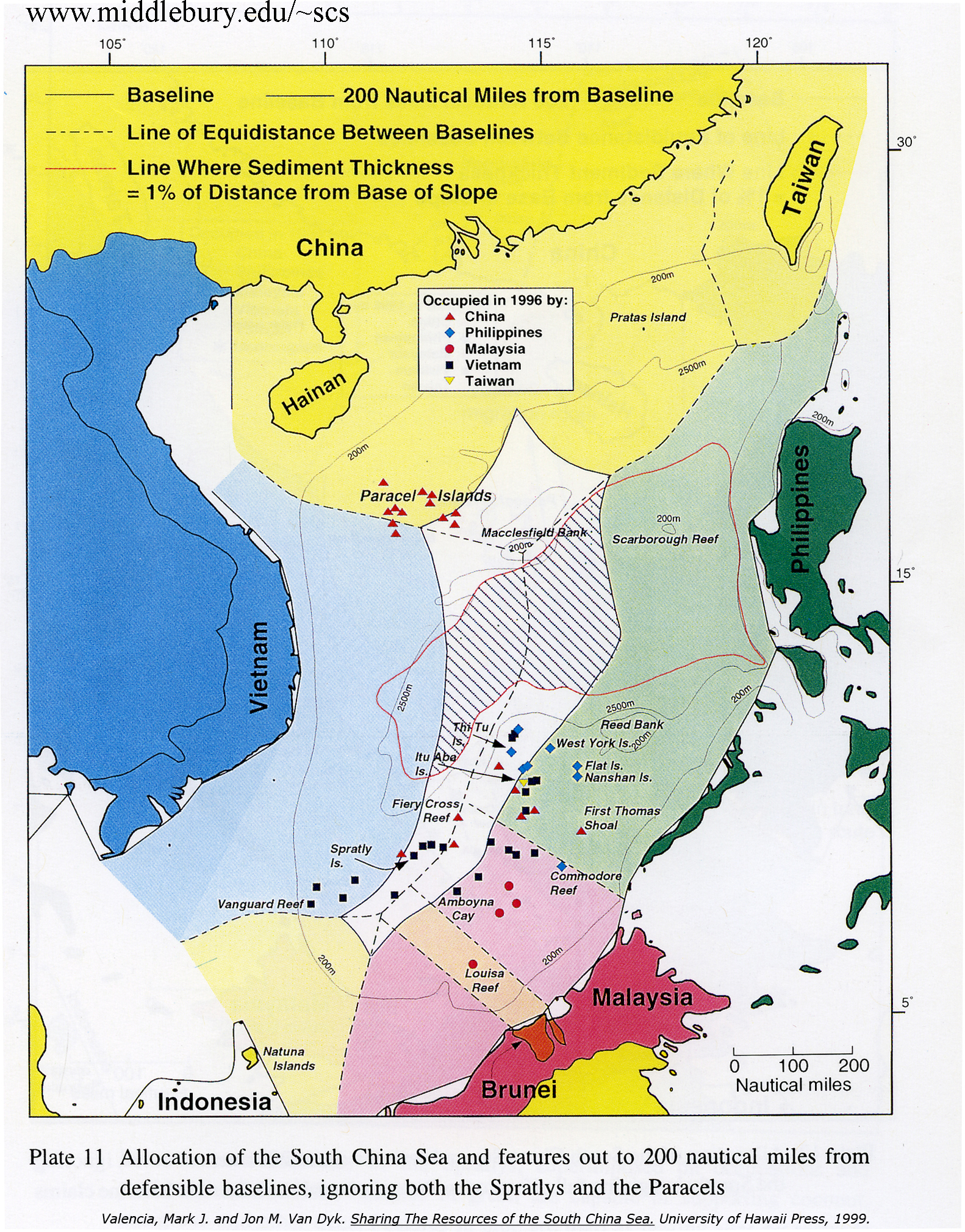
Macclesfield Bank is claimed, in whole or in part, by China[16] and Taiwan (Republic of China).[17][18]
Some sources[18][19] state that the Philippines claims this underwater feature. However, Jose Zaide, a Filipino diplomat of ambassadorial rank, has written that the Philippines does not claim the Macclesfield Bank.[20] Moreover, Macclesfield Bank is not within UNCLOS 200 or Philippines EEZ.[21]
As the bank is entirely underwater, some scholars have raised questions regarding the legality of territorial claims upon it with regards to the United Nations Convention on the Law of the Sea (UNCLOS).[22][23][24][25] However, the Philippines filed claim for another underwater feature, the Benham Plateau, in 2008 in compliance with the requirements of UNCLOS and UN officially approved the claim in April 2012.[26][27][28][29]
Notes
- One problem with this attribution is that there is no record of any Royal Navy vessel named HMS Macclesfield.[10][11] Furthermore, there is no record of an East Indiaman named Macclesfield in 1804.[12] Nor is there any record of a Bombay country ship,[13] or a Calcutta country ship,[14] named Macclesfield.
References
- Jones, Gareth Wyn (2002). "Provinces". In Boland-Crewe, Tara; Lea, David (eds.). The Territories of the People's Republic of China. London: Europa Publications. p. 101. ISBN 978-0-203-40311-2.
- Ministry of Civil Affairs of the People's Republic of China (21 June 2012). 民政部关于国务院批准设立地级三沙市的公告 [Ministry of Civil Affairs Announcement about the State Council Approval of the Establishment of the Prefecture-level City of Sansha] (in Chinese (China)). Archived from the original on 25 June 2012. Retrieved 21 June 2012.
- Sailing Directions (Enroute), Pub. 161: South China Sea and the Gulf of Thailand (PDF). Sailing Directions. United States National Geospatial-Intelligence Agency. 2020. p. 6.
- "Philippines protests China's moving in on Macclesfield Bank". Philippine Daily Inquirer. July 6, 2012. Archived from the original on July 7, 2012. Retrieved July 5, 2012.
- Chemillier-Gendreau, Monique (2000). Sovereignty Over the Paracel and Spratly Islands. Kluwer Law International. ISBN 9041113819.
- China Sea pilot, Volume 1 (8th ed.). Taunton: UKHO - United Kingdom Hydrographic Office. 2010. Archived from the original on 2014-03-21. Retrieved 2018-05-13.
- Horsburgh, James (1852). India Directory, Or Directions for Sailing to and from the East Indies, China, Australia, and the Interjacent Ports of Africa and South America. Vol. 2. William H. Allen & Company. p. 349.
- "Timeline". History of the Spratlys. www.spratlys.org. Archived from the original on 6 January 2008. Retrieved 21 March 2014.
- "HMS Macclesfield (+1804)". wrecksite.eu. Retrieved March 17, 2022.
- Colledge, J. J.; Warlow, Ben (2006) [1969]. Ships of the Royal Navy: The Complete Record of all Fighting Ships of the Royal Navy (Rev. ed.). London: Chatham Publishing. ISBN 978-1-86176-281-8.
-
- Winfield, Rif (2008). British Warships in the Age of Sail 1793–1817: Design, Construction, Careers and Fates (2nd ed.). Seaforth Publishing. ISBN 978-1-86176-246-7.
-
- Hackman, Rowan (2001). Ships of the East India Company. Gravesend, Kent: World Ship Society. ISBN 0-905617-96-7.
- Bulley, Anne (2000). The Bombay Country Ships, 1790–1833. Routledge. ISBN 978-0700712366.
- Phipps, John (1840). A Collection of Papers Relative to Ship Building in India ...: Also a Register Comprehending All the Ships ... Built in India to the Present Time ... Scott.
- Bassett-Smith, P.W. (1890). "Report on the corals from the Tizard and Macclesfield Banks, China Sea". Annals and Magazine of Natural History. 6: 353–374, 485–500. doi:10.1080/00222939008694050.
- "Vietnam Law on Contested Islands Draws China's Ire". The New York Times. June 21, 2012. Archived from the original on June 23, 2012. Retrieved June 28, 2012.
- "Taiwan renews sovereignty claim over South China Sea islands". Focus Taiwan. May 5, 2012. Archived from the original on May 7, 2012. Retrieved June 28, 2012.
- "Limits in the Seas - No. 127 Taiwan's Maritime Claims" (PDF). United States Department of State. November 15, 2005. Archived (PDF) from the original on January 1, 2020. Retrieved July 1, 2012.
- "Philippines protests China's moving in on Macclesfield Bank". Inquirer.net. July 6, 2012. Archived from the original on July 7, 2012. Retrieved July 6, 2012.
- Zaide, Jose (July 10, 2012). "Saan Siya?". Manila Bulletin. Archived from the original on January 13, 2013. Retrieved 31 October 2012.
- "Allocation of South China Sea features". southchinasea.org. Archived from the original on 2015-12-17. Retrieved 2016-01-16.
- Poling, Gregory (2012-07-05). "Time to End Strategic Ambiguity in the South China Sea". Center for Strategic and International Studies. Archived from the original on 2016-03-04. Retrieved 2012-07-21.
- Seoung-Yong Hong; Jon M. Van Dyke (2009). Maritime Boundary Disputes, Settlement Processes, and the Law of the Sea (Publications on Ocean Development). Brill. p. 149.
- Chi-kin Lo (1989). China's Policy Towards Territorial Disputes: The Case of the South China Sea Islands. Routledge. p. 25.
- Clive Ralph Symmons (1995). Some Problems Relating to the Definition of "insular Formations" in International Law: Islands and Low-tide Elevations. International Boundaries Research Unit. p. 12. ISBN 9781897643105.
- "UN approves PH territorial claim to Benham Rise". 28 April 2012. Archived from the original on April 30, 2012. Retrieved April 28, 2012.
- UN to decide on Phl claim on 13-M hectare Benham Rise Archived 2016-08-16 at the Wayback Machine, August 16, 2011, Philippine Star.
- UN approves PH territorial claim to Benham Rise Archived 2016-04-22 at the Wayback Machine, April 28, 2012, Philippine Daily Inquirer.
- "DOE to assess resource potential of Benham Rise". The Philippine Star. June 9, 2014. Archived from the original on August 17, 2016. Retrieved June 9, 2016.
See also
External links
Fisheries and fishing topic areas | ||
|---|---|---|
| Fisheries |
|  |
| Fishing |
| |
| Industry |
| |
| Recreation |
| |
| Techniques |
| |
| Tackle |
| |
| Locations |
| |
| ||
Fishing industry by region | ||
|---|---|---|
| By country |
|  |
| Fishing banks |
| |
| By species |
| |
| Other areas |
| |
| Pratas Island |
| ||||||||||||||||
|---|---|---|---|---|---|---|---|---|---|---|---|---|---|---|---|---|---|
| Paracel Islands |
| ||||||||||||||||
| NorthEast SCS |
| ||||||||||||||||
| Spratly Islands |
| ||||||||||||||||
| Southern SCS |
| ||||||||||||||||
| Tudjuh Archipelago | |||||||||||||||||
| History |
| ||||||||||||||||
| Transport |
| ||||||||||||||||
| |||||||||||||||||
Territorial disputes in East, South, and Southeast Asia | |||||||||
|---|---|---|---|---|---|---|---|---|---|
| |||||||||
| |||||||||
| Authority control |
|
|---|
На других языках
[de] Macclesfield Bank
Macclesfield Bank oder Großes Zhongsha-Atoll (chinesisch 中沙大環礁 / 中沙大环礁, Pinyin Zhōngshā Dà Huánjiāo, vietn. Bãi Macclesfield, eigentlich MacClesfield geschrieben) ist ein versunkenes Atoll mit Unterwasser-Riffen und Untiefen im Südchinesischen Meer und eines der größten Atolle der Welt.- [en] Macclesfield Bank
[fr] Banc Macclesfield
Le banc Macclesfield est un haut-fond situé en mer de Chine méridionale. Il est situé entre les Îles Paracels à l'ouest, les îles Pratas au nord-est et les Îles Spratleys au sud. La République populaire de Chine et Taïwan en revendiquent la souveraineté.Другой контент может иметь иную лицензию. Перед использованием материалов сайта WikiSort.org внимательно изучите правила лицензирования конкретных элементов наполнения сайта.
WikiSort.org - проект по пересортировке и дополнению контента Википедии