geo.wikisort.org - Island
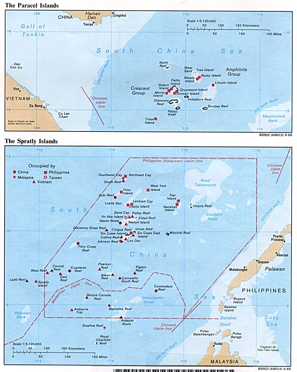
Subi Reef, also known as Zamora Reef (Tagalog: Bahura ng Zamora, lit. 'Reef of Zamora'); Zhubi Reef (Mandarin Chinese: 渚碧礁; pinyin: Zhǔbì Jiāo); Vietnamese: đá Xu Bi, is a reef in the Spratly Islands of the South China Sea located 26 km (16 mi) southwest of Philippines' Pag-asa island Thitu Island under the municipality of the Kalayaan Island Group, Palawan province. It is occupied by China (PRC), and claimed by Taiwan (ROC) and Vietnam. According to the claims of the PRC, it currently falls under the de facto jurisdiction of Nansha islands, Sansha city, Hainan province, China. But under the clauses of the UNCLOS, which the PRC is also a signatory, the international law (if applied) only the Philippines has the maritime rights to exploit its resources or build structures, as it is within the continental shelf ("Extended Continental Shelf") of the coastal country.
| Disputed reef Other names: Zhubi Reef 渚碧礁 Zhǔbì Jiāo (Chinese) Zamora Reef (Philippine English) Bahura ng Zamora (Filipino) đá Xu Bi (Vietnamese) | |
|---|---|
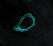
 Sentinel-2 Image (March 2021) | |
 Subi Reef | |
| Geography | |
| Location | South China Sea |
| Coordinates | 10.9133°N 114.062°E |
| Archipelago | Spratly Islands |
| Administered by | |
| Province | Hainan |
| prefecture-level city | Sansha |
| Claimed by | |
Topography and features
The atoll measures 5.7 kilometres (3.5 mi) along its longer southwest-northeast axis, and is up to 3.5 kilometres (2.2 mi) wide. Its total area including the lagoon and rim of the reef measures 16 square kilometres (6.2 sq mi), and the lagoon is up to 22 metres (72 ft) deep.[1]
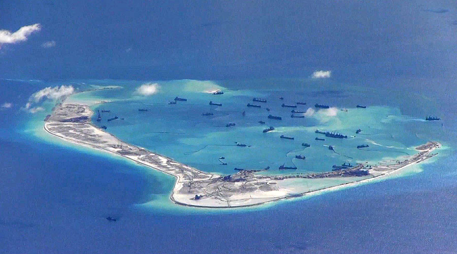
Naturally above water only at low tide, the reef surrounds a lagoon. The People's Republic of China has constructed a 4-story building, a weather observation station with doppler weather radar, wharfs, and an airport in the area. A buoyed channel guides ships to the inner lagoon which is 3.7 kilometres (2.3 mi) in diameter.[2][3][4][5]
UNCLOS Maritime Ruling
On 12 July 2016, the UNCLOS special arbitral tribunal in the Philippines v. China case confirmed that Subi Reef is, or in its natural condition was, exposed at low tide and submerged at high tide and is, accordingly a low-tide elevation that does not generate entitlement to a territorial sea, exclusive economic zone or continental shelf, but is within 12 miles of a high-tide feature, Sandy Cay on the reefs west of Pag-asa Island (Thitu Island).[6]
As the Subi Reef is under the water, it is considered by the Third United Nations Conference on the Law of the Sea (UNCLOS III) as "sea bed" in "international waters". Although the PRC had ratified a limited UNCLOS III not allowing innocent passage of warships,[7] according to the UNCLOS III, features built on the sea bed cannot have territorial waters.[7] Therefore, the PRC's claims and build-up on the reef are legal. The Philippines however, having a limited naval force, was unable to enforce occupation over the reef.
Environmental issues
The PRC has ratified UNCLOS III;[7] the convention establishes general obligations for safeguarding the marine environment and protecting freedom of scientific research on the high seas, and also creates an innovative legal regime for controlling mineral resource exploitation in deep seabed areas beyond national jurisdiction, through an International Seabed Authority and the Common heritage of mankind principle.[8]
Territorial disputes
The reef is controlled by China (PRC), with a 2014 estimate of 200 troops stationed there,[9] and claimed by Taiwan (ROC), and Vietnam. In July 2012, a large fleet of 30 Chinese fishing vessels arrived at the reef from Hainan.[10]
In April 2015, a Philippine Navy aircraft patrolling near the reef received "aggressive action" from a Chinese ship.[11] Also in 2015, the USS Lassen sailed within 12 nautical miles (which if applicable is the territorial waters limit of the reef), prompting the Chinese Foreign Ministry to call the action a "provocation" and vowed to keep building up in the South China Sea. As per the US Navy, this was a routine "freedom of navigation" exercise. Similar exercises are performed routinely about 12–28 times per year.[12][13]
During 2014, the PRC started reclaiming land at Subi Reef, and by the end of 2015 had developed it into an island of 3.95 square kilometres (1.53 sq mi), with a military base, a large harbor, and an airstrip of about 3,000 metres (9,800 ft).[14][15] In November 2015, two U.S. B-52 strategic bombers flew in airspace near the area. They were contacted by Chinese ground control, but were allowed to continue their mission undeterred.[16] In April 2016 a new lighthouse 55 meters (180') high commenced operations.[17] A civilian test flight to the new airport was conducted by a passenger jet of Hainan Airlines on July 13, 2016.[18]
See also
- Fiery Cross Reef
- Great wall of sand
- Nine-dotted line
References
- Atoll Area, Depth and Rainfall: Zhubi
- Anda, Redempto (17 July 2012). "Government told of China buildup 2 months ago". Philippine Inquirer. Retrieved 29 October 2013.
- Jingya, Mei (19 July 2012). "China installed radar on Zhubi Reef:Philippine media". Sina English News. Retrieved 29 October 2013.
- "Digital Gazetteer of the Spratly Islands". www.southchinasea.org. Archived from the original on July 17, 2007. Retrieved 2008-03-22.
- "高清:菲律宾称中国将在南沙渚碧礁建机场". qq.com. Tencent QQ. Retrieved August 9, 2016.
Chinese language page with a collection of 10 photos of the reef and Thitu (Pagasa) Island dated 25 July 2012. Pictures 1,3,4&6 show the buildings on the reef; 5 shows a lighthouse, 7–10 show Pagasa
- "Award". Permanent Court of Arbitration. 12 July 2016. p.174
- "UNCLOS. Declarations upon ratification".
- Jennifer Frakes, The Common Heritage of Mankind Principle and the Deep Seabed, Outer Space, and Antarctica: Will Developed and Developing Nations Reach a Compromise? Wisconsin International Law Journal. 2003; 21:409
- DJ Sta. Ana (June 13, 2014). "China reclaiming land in 5 reefs?". www.abs-cbnnews.com. Retrieved September 11, 2014.
- Cunfu, Wang (18 July 2012). "Fishing vessels arrive at Zhubi Reef of south China Sea". Xinhua. Archived from the original on July 24, 2012. Retrieved 29 October 2013.
- "Philippine military says Chinese ship took aggressive action". Gulf News. United Arab Emeritus. Associated Press. 18 April 2015. Retrieved 5 April 2015.
- Perlez, Jane (2015-10-27). "Beijing Calls U.S. Warship's Route in South China Sea a 'Provocation'". The New York Times. ISSN 0362-4331. Retrieved 2015-10-27.
- "A U.S. Naval Signal in the South China Sea". Council on Foreign Relations. Retrieved 2015-11-02.
- Gregory Poling. "Potential New Runway Presents New Headaches". Asia Maritime Transparency Initiative. Retrieved 2015-10-30.
- "Subi reef tracker". Center for Strategic and International Studies. Archived from the original on 2016-05-15. Retrieved 2016-03-05.
- [dead link]
- Prashanth Parameswaran (2016-04-06). "China Unveils New South China Sea Lighthouse on Subi Reef". The Diplomat. Retrieved 2016-04-24.
- "China conducts test flights on two new airports on Nansha Islands". Xinhua. Archived from the original on August 22, 2016. Retrieved 2016-07-14.
External links
| Confrontations |
| ||||||||||||
|---|---|---|---|---|---|---|---|---|---|---|---|---|---|
| Regions |
| ||||||||||||
| Occupied features |
| ||||||||||||
| Unoccupied features |
| ||||||||||||
| Related articles |
| ||||||||||||
| Pratas Island |
| ||||||||||||||||
|---|---|---|---|---|---|---|---|---|---|---|---|---|---|---|---|---|---|
| Paracel Islands |
| ||||||||||||||||
| NorthEast SCS |
| ||||||||||||||||
| Spratly Islands |
| ||||||||||||||||
| Southern SCS |
| ||||||||||||||||
| Tudjuh Archipelago | |||||||||||||||||
| History |
| ||||||||||||||||
| Transport |
| ||||||||||||||||
| |||||||||||||||||
На других языках
[de] Subi-Riff
Subi-Riff, auch chinesisch: Zhubi Jiao (渚碧礁), Zamora Riff (Tagalog: Bahura ng Zamora), Vietnamesisch: đá Xu Bi, ist ein Atoll der Spratly-Inseln im Südchinesischen Meer. Das Atoll steht unter der Kontrolle der Volksrepublik China, wird aber auch von den Philippinen und Vietnam beansprucht. Seit 2015 treibt die Volksrepublik China den Bau eines Luftwaffenstützpunktes voran. Die VR China verwaltet das Atoll als Teil der Stadt Sansha in der Provinz Hainan.- [en] Subi Reef
[fr] Récif de Subi
Le récif de Subi (Zhubi Reef / chinois : 渚碧礁 ; pinyin : zhǔbì jiāo / Zamora / đá Xu Bi) est un récif contrôlé par la République populaire de Chine en mer de Chine méridionale. Il est situé dans les îles Spratleys, également revendiquées par les Philippines, le Viet-Nam et Taïwan.Другой контент может иметь иную лицензию. Перед использованием материалов сайта WikiSort.org внимательно изучите правила лицензирования конкретных элементов наполнения сайта.
WikiSort.org - проект по пересортировке и дополнению контента Википедии