geo.wikisort.org - Island
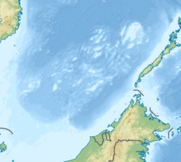
Cuarteron Reef, also known as Calderon Reef (Mandarin Chinese: 華陽礁/华阳礁; pinyin: Huáyáng Jiāo; Vietnamese: Đá Châu Viên; Malay: Terumbu Kalderon; Calderon Reef; Tagalog: Bahura ng Calderon), is a reef at the east end of the London Reefs in the Spratly Islands of the South China Sea. It is occupied and controlled by China (PRC) (as part of Sansha), and also claimed by the Philippines (as part of Kalayaan), by Vietnam (as part of Truong Sa) and Taiwan (ROC). The reef is 3 nautical miles (5.6 km; 3.5 mi) long and has an area of 8 square kilometres (3.1 sq mi) (800 hectares (2,000 acres)).[1]
| Disputed island Other names: 華陽礁/华阳礁 Huáyáng Jiāo (Chinese) Đá Châu Viên (Vietnamese) Terumbu Kalderon (Malay) Calderon Reef (Philippine English) Bahura ng Calderon (Filipino) | |
|---|---|
 Cuarteron Reef | |
 Cuarteron Reef | |
| Geography | |
| Location | South China Sea |
| Coordinates | 8°51′50″N 112°49′40″E |
| Archipelago | Spratly Islands |
| Administered by | |
| Province | Hainan |
| City | Sansha |
| Claimed by | |

Geographical features
On 12 July 2016, the tribunal of the Permanent Court of Arbitration concluded that Cuarteron Reef contains, within the meaning of Article 121(1) of the Convention, naturally formed areas of land, surrounded by water, which are above water at high tide. However, for purposes of Article 121(3) of the convention, the high-tide features at Cuarteron Reef is rocks that cannot sustain human habitation or economic life of their own and accordingly shall be entitled to 12nmi of territorial sea measured from its baseline but have no exclusive economic zone or continental shelf.[2]
Chinese construction projects
Prior to 2016, Carteron reef had a supply platform and a reef fortress. In 2015 the Philippine government released what it claimed were photos of a six-story facility being built by the Chinese government on the reef.[3] Also in 2015, China completed the construction of a 50 metres (160 ft) high[4] lighthouse on the reef.[5][6] By late 2015, China had expanded the reef's usable area to 23 hectares (57 acres),[7] reportedly including in the process two helicopter pads, and possibly gun, radar and missile emplacements.[8] As of 2016, China was reportedly building a high-power radar installation on the reef.[9]
In late 2016, photographs emerged which suggested that Cuarteron Reef has been armed with anti-aircraft weapons and a CIWS missile-defence system.[10][11]
See also
- Great wall of sand
- Nine-Dash Line
References
- D. J. Hancox; John Robert Victor Prescott (1995). A Geographical Description of the Spratly Islands and an Account of Hydrographic Surveys Amongst Those Islands. IBRU. pp. 14–. ISBN 978-1-897643-18-1.
- "Award" (PDF). PCA Case No 2013-19. Permanent Court of Arbitration. 12 July 2016. Archived from the original (PDF) on 29 January 2019. Retrieved 17 July 2016. p.259
- "China expands construction work on reefs in dispute with the Philippines". The Asahi Shimbun. Archived from the original on 3 March 2016. Retrieved 23 February 2016.
- Lin, Ting-Hui. "China's Lighthouses in the Spratlys". The Diplomat. Retrieved 23 February 2016.
- "South China Sea: China completes construction of lighthouses on artificial island on Cuarteron Reef". Australian Broadcasting Corporation. Retrieved 22 February 2016.
- "China ups the ante with lighthouses in S China Sea". Today. Retrieved 23 February 2016.
- "Cuarteron reef tracker". Center for Strategic and International Studies. Archived from the original on 2016-03-04. Retrieved 2016-03-05.
- Page, Jeremy; Lubold, Gordon. "U.S. Bomber Flies Over Waters Claimed by China". The Wall Street Journal. Retrieved 23 February 2016.
- Denyer, Simon (22 February 2016). "Satellite images show China may be building powerful radar on disputed islands". The Washington Post. Retrieved 22 February 2016.
- "China's New Spratly Island Defenses". Center for Strategic and International Studies. 2016-12-13. Retrieved 2016-12-17.
- "Cuarteron reef". Center for Strategic and International Studies. October 2017. Retrieved 2018-05-14.
External links
На других языках
[de] Huayang Jiao
Huayang Jiao (chinesisch .mw-parser-output .Hani{font-size:110%}华阳礁, Pinyin Huáyáng Jiāo oder auch Cuarteron Reef; vietnamesisch: đá Châu Viên; philippinisch Calderon Reef) ist ein Riff am östlichen Ende der Kette der vier London Reefs (Yinqing Qunjiao, chinesisch 尹庆群礁) der Nansha-Inseln im Südchinesischen Meer, das seit 1988 von der Volksrepublik China kontrolliert wird.[1] Huayang Jiao wird von der Volksrepublik China als Teil der Stadt Sansha seiner Provinz Hainan verwaltet, die Philippinen, Vietnam und die Republik China erheben im Rahmen der Territorialkonflikte im Südchinesischen Meer Anspruch auf die Insel.- [en] Cuarteron Reef
[fr] Récif de Cuarteron
Le récif de Cuarteron est un récif situé dans les îles Spratleys en mer de Chine méridionale. Il est contrôlé par la République populaire de Chine, mais est revendiqué par le Viet-Nam. Il fait l'objet d'aménagement dans le cadre de la grande muraille de sable.Другой контент может иметь иную лицензию. Перед использованием материалов сайта WikiSort.org внимательно изучите правила лицензирования конкретных элементов наполнения сайта.
WikiSort.org - проект по пересортировке и дополнению контента Википедии