geo.wikisort.org - Island
Gaodeng Island[2] (Kaoteng,[3][4][5] Kao-teng Tao[6][7]) (Chinese: 高登島; pinyin: Gāodēng Dǎo; Wade–Giles: Kao1-têng1 Tao3; Foochow Romanized: Gŏ̤-dĕng-dō̤, also Pei-sha Tao[7] (北沙島[7][8]), 下目嶼,[9] 下木嶼[10]) is an island in the East China Sea, part of Beigan Township, Lienchiang County (the Matsu Islands), Fujian Province, Republic of China (Taiwan).[11][12][8] The island is closed to the public.[13][14] Gaodeng is located 9.25 kilometres (5.75 mi) away from the Beijiao Peninsula (北茭半岛) in Lianjiang County, Fuzhou, Fujian, China (PRC).[4][8][15][16][17] The island can be seen from the nearby Beigan Island and Daqiu Island.
This article may be expanded with text translated from the corresponding article in Chinese. (August 2019) Click [show] for important translation instructions.
|
Native name: 高登島 | |
|---|---|
 Gaodeng Island, as seen from Daqiu Island | |
 Gaodeng in Lienchiang County (the Matsu Islands) | |
 Gaodeng Island Location in the East China Sea | |
| Geography | |
| Location | north of Beigan Island, Beigan Township, Lienchiang County (the Matsu Islands), Fujian, Republic of China (Taiwan) |
| Area | 1.39 km2 (0.54 sq mi)[1] |
| Administration | |
Republic of China (Taiwan) | |
| Province | Fujian (streamlined) |
| County | Lienchiang (the Matsu Islands) |
| Rural Township | Beigan |
| Additional information | |
| Time zone |
|

History
In 1368, fisherman residents of the nearby Huangqi Peninsula (黃岐半島) moved to and lived on the island.[10]
On February 13, 1951, under cover of fog, eight Chinese Communist motorized junks and more than twenty wooden ships surrounded and attacked the island. After two hours of fighting, the Chinese Communist forces were repelled.[18]
In the early morning of November 20, 1954, ROC soldier Wang Hsi-Tien (汪喜田) was severely injured while capturing a frogman soldier from mainland China who had landed on the island. Communist soldiers who swim to the islands from the mainland are referred to among the soldiers as 'water goblins' (水鬼).[19]
On March 4, 1955 during the First Taiwan Strait Crisis, an assault on Kaoteng Island (Gaodeng) by forty Communist motorized junks was driven off.[18][3][20]
On the three days of October 7, 11 and 14, 1955, a total of 49 rounds were fired at Kaoteng (Gaodeng) in Chinese Communist shelling of the island. On October 29, 12 rounds were fired at Gaodeng Island from Fenjishan (糞箕山) on the Beijiao Peninsula. On December 28, Nationalist and Communist forces clashed for an hour in the waters near Gaodeng Island.[5] There were reports of shelling directed at Kaoteng (Gaodeng) later in the year.[16][18] On February 3, 1956, Gaodeng Island was shelled over 600 times. On February 9, the island was shelled 154 times. On March 19, the island was shelled 119 times and Nationalist forces returned fire, firing thirteen shells. On April 24, the island was shelled 246 times. On May 17, the island was shelled 136 times.[18]
On August 19, 1958, President Chiang Kai-shek visited the island.[18]
On February 6, 1960, Chinese Communists fired 165 shells at the island. Nationalist forces sustained no injuries.[18]
In September/October 1975, frogmen ('water goblins') from mainland China landed on the island twice and left threatening messages in graffiti.[19]
On December 26, 2000, a Chinese fishing boat was spotted 2 kilometres (1.2 mi) from Kaoteng Island (Gaodeng). The Coast Guard fired 16 rounds of ammunition into the air as a warning. Six crew members aboard were arrested on the spot and the ship sank into the sea.[21]
On the morning of September 9, 2005, President Chen Shui-bian visited Gaodeng Island and other nearby islands.[22]
In April 2019, a Beigan-registered fishing boat reported that it was attacked and chased off by numerous Chinese boats in Taiwan-controlled waters between Gaodeng and Zhongdao (中島) on the afternoon of April 17. The next day, a Taiwan (ROC) Coast Guard vessel was pelted with rocks by the crew of a Chinese ship off the coast of the Matsu Islands.[23][24]
Geography
Mountains on the island include Beishan ('north mountain', Mt. Beishan; 北山) which reaches 72 m (236 ft) above sea level and Nanshan ('south mountain', Mt. Nanshan; 南山) which reaches 99 m (325 ft) above sea level. Ports include Nan-ao Port (南澳港), Tiejian Port (鐵尖港) and Dawei Port (大維港).[25]
Gallery
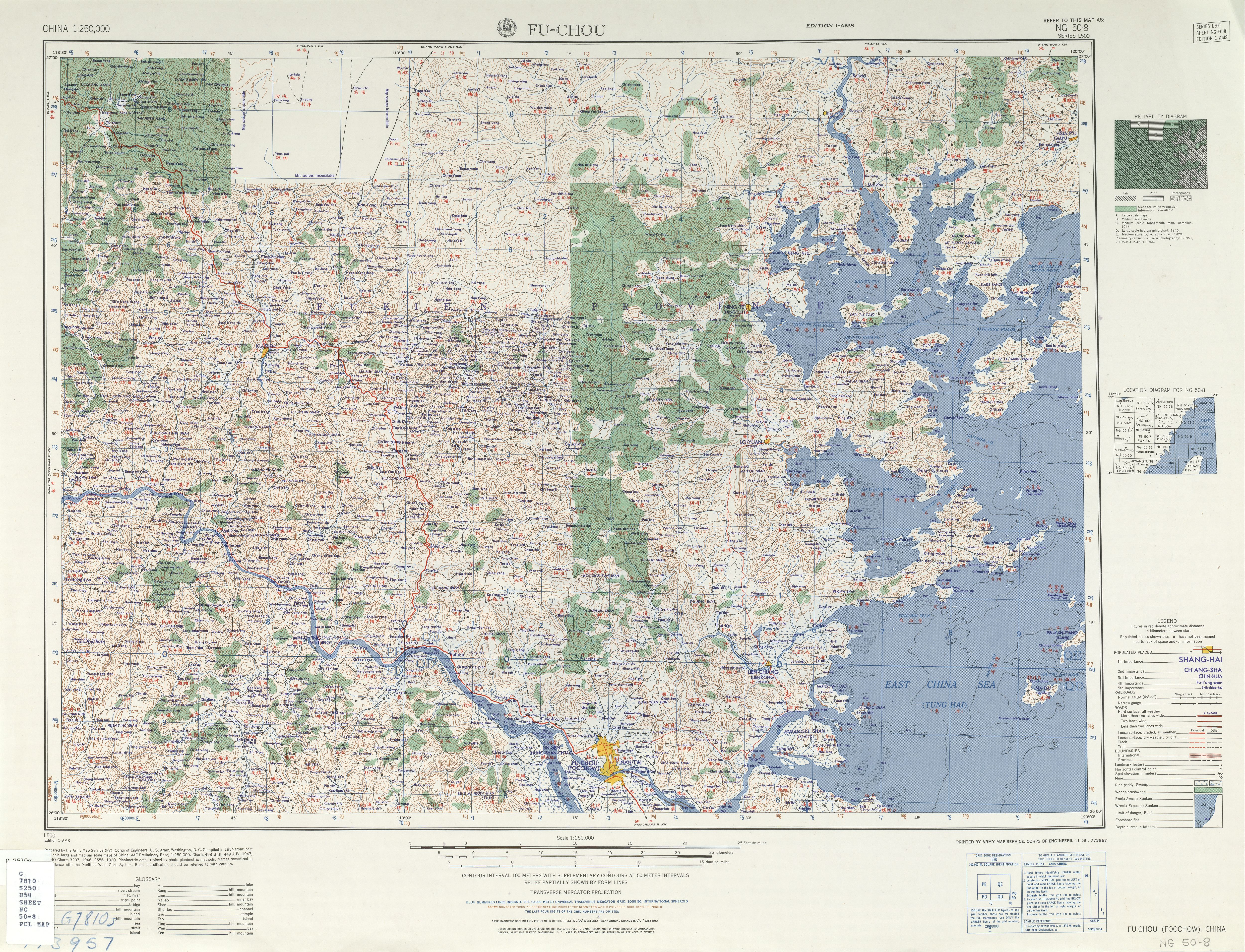
 Gaodeng Island (labelled as Kao-teng Tao (Pei-sha Tao) 高登島 (北沙島)) (AMS, 1954)
 Gaodeng Island (labelled as 下目山)
 Gaodeng Island (middle-left) as seen from Qinbi Village on Beigan Island
 Gaodeng Island as seen from Daqiu Island
 Gaodeng Island as seen from Daqiu Island


See also
References
- 北竿鄉志 第一章:地理 (in Chinese (Taiwan)). Retrieved 2 September 2019.
三、面積 北竿鄉全境總面積9.3平方公里,佔全縣總面積29.60平方公里的31﹪,僅次於南竿鄉的35﹪,為全縣次大的鄉。其中北竿本島6.43平方公里,高登島1.39平方公里,大坵島0.53平方公里,亮島0.35平方公里,小坵0.16平方公里。
- 馬祖地區離島通航航道公告圖 (in Chinese (Taiwan) and English). 14 April 2017. Archived from the original on 3 February 2020. Retrieved 9 February 2020 – via Internet Archive.
高登島
Gaodeng Island - MARCH 26-APRIL 2, 1955. Keesing's Contemporary Archives. Vol. 10. 1955–1956. p. 14117 – via Internet Archive.
An attempted assault by 40 Communist motorised junks on Kaoteng Island (in the Matsu group) was driven off on March 4,
- DeWitt Copp, Marshall Peck (1962). The Odd Day. New York City: William Morrow & Company. pp. 58, 67, 71, 206 – via Internet Archive.
Kueffer indicated two islands bunched near Peikan, "Tachiu and Kaoteng. The latter is five miles off the mainland, the closest to the enemy."
{{cite book}}: CS1 maint: uses authors parameter (link) - "CENTRAL INTELLIGENCE BULLETIN". Office of Current Intelligence, CIA. 20 October 1955. p. 6. Retrieved 27 August 2019 – via Internet Archive.
1. Military activity in the area was marked by the first Chinese Nationalist success against Chinese Communist jet fighters and by the first Communist shelling of an island in the Matsu group. {...} Communist shelling of Kaoteng, northernmost island in the Matsus, was light, and apparently has been fired either for registration or harassment. A total of 49 rounds was fired at Kaoteng on 7, 11 and 14 October.
- Daniel Ellsberg (February 1963). "DRAFT NOTES ON OFFSHORE ISLANDS". p. 24. Retrieved 26 August 2019 – via Internet Archive.
For US purposes we have defined the OSI to include Kinmen, and Little Kinmen and the 5 larger islands of the Matsu area (Kao-teng Tao, Peikan Tang, Ma-tsu shan, Hsi-ch'uan Tao, Tung-ch'uan Tao).
- "NG 50-8 FU-CHOU" (in English and Chinese). Washington, D. C.: Army Map Service. 1954 – via Perry–Castañeda Library Map Collection.
高登島 (北沙島) Kao-teng Tao (Pei-sha Tao)
- 辞海第六版. Cihai (Sixth Edition) (in Chinese). 上海. Shanghai: 上海辞书出版社. Shanghai Lexicographical Publishing House. September 2009. p. 1516. ISBN 9787532628599.
马祖列岛 中国闽江口外25~40千米的岛群。{...}属福建省连江县,现由台湾当局管辖。{...}由马祖岛(又称南竿塘)、北竿塘、高登岛3个较大岛{...}组成。{...}高登岛又称北沙岛,距黄岐半岛9.2千米,面积1.25平方千米,地形南宽北窄,地势南高北低,南部下目山177米为全岛制高点。
- 林金炎 (10 April 2013). 明代-馬祖海防與兵紀. Matsu Daily (in Chinese (Taiwan)). Retrieved 28 August 2019.
「北與烽火門會哨,南與南日會哨,西洋、下目(高登)、下竿塘、白犬(莒光)皆其汛地。」《萬曆府志海防篇 卷八十六》
- Meng-hsing Ho 何孟興. 明代福州海防要地「竿塘山」之研究(1368–1456 年) [Research on the strategic coast defense position ‘Gan-Tang-Shan’ in Fu-Jhou in Ming Dynasty] (PDF). Chaoyang University of Technology (in Chinese (Taiwan) and English). p. 6. Retrieved 28 August 2019.
另外,北竿北面不遠處的高登島,明時 稱作「下目」或「下木」島,22該地亦在同年(1368)由對岸的黃岐半島漁民遷 此聚居。23就在對岸居民絡繹前往北竿、高登二島定居之時,明帝國的東部邊海 便不安寧,「先是元末瀕海盜起,張士誠、方國珍餘黨導倭出沒海上,焚民居、 掠貨財,北自遼海、山東,南抵閩、浙、東粵,濱海之區無歲不被其害」。{...}有關高登島的地理環境,如下:「下木澳,《籌海重編》作「下目澳」,又有上目澳,在(其) 南(邊)。(下木澳)與黃崎對峙,在北茭之東,可泊南、北風船二十餘(艘),北至西洋(山)、 南至竿塘(山),各一潮水」。見同註 10,卷 5,頁 54。文中的《籌海重編》一書,係明人鄭若 曾所作。
- 連江縣土地段名代碼表 (in Chinese (Taiwan)). Department of Land Administration. 16 May 2012. Retrieved 27 August 2019.
地政事務所名稱(代碼) 連江(ZA) 鄉鎮市區名稱(代碼) 北竿鄉(02) 段 小段 代碼 備註{...}高登 0022
- 教育部重編國語辭典修訂本 (in Chinese (Taiwan)). Retrieved 27 August 2019.
字詞 【馬祖島】{...}釋義 島名。位於福建省閩江口東北,屬連江縣。簡稱為「馬祖」。由南竿、北竿、大坵、高登、西引等十九個小島組成,總面積三十四平方公里,控福州對外交通的要衝,扼閩江出入的門戶。{...
} - "The highest density of military tunnels and strongholds in the world". Lienchiang County. 23 November 2016. Retrieved 27 August 2019.
Now, only the secretive military-controlled islands of Gaodeng and Liang are closed to the public.
- "Battlefield Scenery". Matsu National Scenic Area. 5 September 2018. Retrieved 27 August 2019.
Today, Gaodeng and Liangdao, the only islands where the military remains stationed, are still shrouded in mystery, not having been opened to visitors.
- "FAQ". Matsu National Scenic Area. 29 July 2019. Retrieved 27 August 2019.
The area closest to the mainland is Gaodeng Island, 9.25 km off the Beijia [sic] Peninsula.
- "Chinese Reds Shell Islands; Fight Feared". Times-News. Twin Falls, Idaho. 30 December 1955 – via Internet Archive.
Sporadic Communist shelling was directed against Kaoteng in the Matsu island group 150 miles up the coast. Kaoteng is five miles from the nearest Communist position and serves as an outpost for the main Matsu island.
- 境域面积. 福州市连江县政府 (in Simplified Chinese). 22 January 2020. Retrieved 15 March 2020.
东南为马祖列岛,距大陆最近点9.25公里;
- 北竿鄉志 大事記(民國十七年至四十九年) [History of Beigan Major Events (1928-1960)]. 馬祖資訊網 (in Chinese (Taiwan)). Retrieved 2 September 2019.
八月十九日 蔣中正總統視察高登,慰問官兵,並以「要與陣地共存亡」勉官兵。
- Lin Pao-Pao 林保寶 (March 2000). 牆上烽火 (in Chinese (Taiwan)). Luchou, Taipei County, Taiwan: BoyYoung 博揚文化事業有限公司. p. 134. ISBN 957-97552-6-4.
- Sampson C SHEN 沈錡, ed. (1959). CHINA YEARBOOK 1958-1959. Taiwan. pp. 559–561.
1955{...}Mar. 3{...}Second Chinese Communist invasion of Kaoteng (Matsu Islands), five km. (three mil.) north of Nankan repulsed.
- Chyungly Lee (March 2003). "Maritime Confidence Building Measures Across the Taiwan Strait: Technical Collaboration for Human Security at Sea" (PDF). Sandia National Laboratories. Taipei. p. 16. Retrieved 27 August 2019.
12/26/2000 Coast Guard stations in Matsu and Kinmen found unusual large-scale gatherings of Chinese fishing boats. Matsu spotted a Chinese fishing boat lurking just 2 km from Kaoteng Island, part of the Taiwan-controlled archipelago. The Coast Guard fired 16 rounds of ammunition into the air as a warning. Six crew members aboard were arrested on the spot and the ship sank into the sea.
- 總統視導馬祖防衛司令部隊. 中華民國總統府 Office of the President Republic of China (Taiwan) (in Chinese (Taiwan)). 9 September 2005. Retrieved 14 November 2019.
今天一整個上午,阿扁的足跡踏遍南竿、北竿、東引、亮島、高登、東莒和西莒,從官兵弟兄們的眼神裡,阿扁看見一份堅持,也看見一股希望。
- Feng Shao-fu, Ko Lin (19 April 2019). "Taiwan sends warning to rock-pelting Chinese fishing boats". Focus Taiwan. Retrieved 27 August 2019.
The response came after a Beigan-registered Taiwanese fishing boat reported Wednesday that it was attacked and chased off by numerous Chinese boats in Taiwan-controlled waters between Gaodeng and Zhongdao islets.
- 中國漁船馬祖海域挑釁 海巡增援威力掃蕩. Central News Agency (in Chinese (Taiwan)). 19 April 2019. Retrieved 14 November 2019.
北竿1漁船17日下午在高登與中島附近作業時,疑因釣魚糾紛,漁船被多艘中國大陸小艇圍攻。漁船船長事後表示,中國大陸小艇利用速度優勢,並透過對講機呼叫多艘小艇聯合對漁船展開追逐,並丟擲石塊攻擊,造成漁船玻璃窗破碎;18日還發生中國大陸小艇直接朝前來查緝的海巡隊小艇丟擲石頭事件。
- 連江縣行政區域圖 [Lienchiang County] (Map) (in Chinese (Taiwan) and English). Ministry of the Interior, Lienchiang County Government. August 2007. ISBN 978-986010698-5.
亮島 Liangdao Island
External links
- 馬祖日報2017/07/22影音/推運補油桶、吃軍用罐頭 高登鐵漢22日回家 ('Matsu Daily July 22, 2017 Recording / Push the oil drum, eat military rations / Gaodeng's Men with Nerves of Steel Return Home on the 22nd') (in Chinese)
На других языках
- [en] Gaodeng Island
[fr] Île Kaoteng
L'île Kaoteng (chinois traditionnel: 高登島, Gāodēng Dǎo) ou à l'origine île Xiamu (chinois:下目, Xiàmù), est rattachée à l'île de Beigan. Elle mesure 2 km du nord au sud et 0,92 km d'est en ouest; couvrant une superficie de 1,84 km2. Elle est située dans la partie orientale du comté de Lienchiang au nord-est de l'île Mazulie et à 9 kilomètres de la Chine continentale.Другой контент может иметь иную лицензию. Перед использованием материалов сайта WikiSort.org внимательно изучите правила лицензирования конкретных элементов наполнения сайта.
WikiSort.org - проект по пересортировке и дополнению контента Википедии