geo.wikisort.org - Island
Graciosa Island or commonly La Graciosa (pronounced [la ɣɾaˈsjosa]; Spanish for "graceful") is a volcanic island in the Canary Islands of Spain, located 2 kilometres (1+1⁄4 miles) north of Lanzarote across the Strait of El Río. It was formed by the Canary hotspot. The island is part of the Chinijo Archipelago and the Chinijo Archipelago Natural Park (Parque Natural del Archipiélago Chinijo).[4][5] It is administrated by the municipality of Teguise in the neighboring island of Lanzarote. In 2018 La Graciosa officially became the eighth Canary Island[6] with few real effects.[7] Before then, the island had the status of an islet, administratively dependent on the island of Lanzarote. The only two settlements on the island are Caleta de Sebo in the southeastern part of the island and summer-residence Casas de Pedro Barba.
This article may be expanded with text translated from the corresponding article in Spanish. (May 2020) Click [show] for important translation instructions.
|
 La Graciosa from Mirador Del Río | |
 La Graciosa Location with respect to Lanzarote 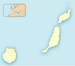 La Graciosa La Graciosa (Province of Las Palmas)  La Graciosa La Graciosa (Canary Islands)  La Graciosa La Graciosa (Spain, Canary Islands) | |
| Geography | |
|---|---|
| Location | Atlantic Ocean |
| Coordinates | 29.250°N 13.508°W |
| Archipelago | Chinijo Archipelago, Canary Islands |
| Area | 29.05 km2 (11.22 sq mi)[1] |
| Coastline | 30.395 km (18.8866 mi)[2] |
| Highest elevation | 266 m (873 ft) |
| Highest point | Agujas Grandes |
| Administration | |
| Autonomous Community | |
| Province | Las Palmas |
| Municipality | Teguise |
| Largest settlement | Caleta de Sebo (pop. 730) |
| Demographics | |
| Population | 734 (2018)[3] |
| Pop. density | 25.27/km2 (65.45/sq mi) |
| Languages | Spanish, specifically Canarian Spanish |
| Additional information | |
| Time zone |
|
| • Summer (DST) |
|
The population is about 700. Tourism is the main industry along with fishing. Every year, tourists flock to the island for its tempered climate and its sandy volcanic coasts. The island has a school, lyceum, post office, supermarkets, medical center, pharmacy, a Bankia bank branch,[8] port, beaches, bar-restaurants and a square. Because of the transportation cost, everyday shopping is more expensive than in the other islands.[7]
Streets and roads on La Graciosa are unpaved sand. Motor vehicles are strictly limited to a handful of licensed vehicles for special purposes. Access to the island is by a 25-minute ferry crossing from Órzola on Lanzarote to the harbour in the village. There is a campsite on the island situated on Playa del Salado at the western edge of Caleta del Sebo.
Geographical features
The island is extremely arid and entirely made up of bushes and dry soil. Its length is 8 km (5 mi) and the width is 4 km (2+1⁄2 mi), with an area of 29 km2 (11 sq mi). There are no natural water sources on the island; desalinated water has been piped directly from neighbouring Lanzarote since 2001. Water supply is at risk when the pipe gets broken.[7]
There are several isolated hills on the island, the tallest of which is Agujas Grandes, rising to 266 m (873 ft). The second-tallest is Agujas Chicas at 228 m (748 ft). Playa de la Cocina is a well known beach in the southwestern part of the island.

References
- "Estadística del Territorio" [Territory Statistics] (in Spanish). Instituto Canario de Estadística (ISTAC). Retrieved 2019-07-18.
- "Longitud de costa de los islotes de Lanzarote" [Coastline length of the islets of Lanzarote] (in Spanish). Centro de Datos, Cabildo de Lanzarote. Retrieved 2019-07-18.
- "Población de derecho de Teguise según unidad poblacional. Evolución (2000-2018)" [Legal population of Teguise by settlement. Evolution (2000-2018)] (in Spanish). Centro de Datos, Cabildo de Lanzarote. Retrieved 2019-07-18.
- Protected Natural Areas Archived 2015-04-17 at the Wayback Machine
- Boletín Oficial de Canarias, pages 9723 and 9865-7
- Hugh Morris, Travel news editor. "Nine fascinating facts about the newest Canary Island". The Telegraph. Retrieved 2019-11-21.
{{cite web}}:|first=has generic name (help) - Ferrera, Toni (7 November 2022). "La Graciosa, la isla canaria que logró su 'independencia' hace cuatro años sin mucho éxito". elDiario.es (in Spanish). Retrieved 7 November 2022.
- "Bankia branch in CL THE TEGALA, 3 (Teguise)". bankia.es. Retrieved 2019-07-20.
- R. Pott, J. Hüppe, W. Wildpret de la Torre, Die Kanarischen Inseln. Natur- und Kulturlandschaften, Ulmer Eugen Verlag, 2003, ISBN 9783800132843
Islands and provinces of the Canary Islands | ||
|---|---|---|
| Main islands |  | |
| Other islands | ||
| Provinces | ||
Authority control | |
|---|---|
| General |
|
| National libraries | |
На других языках
[de] La Graciosa
La Graciosa ist die kleinste bewohnte Insel der politisch zu Spanien gehörenden Kanarischen Inseln im Atlantischen Ozean. Seit November 2018 ist sie per Autonomiestatut als achte bewohnte Insel der Kanaren anerkannt.[1]- [en] Graciosa, Canary Islands
[es] La Graciosa
La Graciosa es una isla perteneciente a la provincia de Las Palmas, en Canarias, Comunidad Autónoma de España. Forma parte del archipiélago Chinijo junto con los islotes de Montaña Clara, Roque del Este, Roque del Oeste y Alegranza, y todos ellos forman parte del municipio de Teguise, en Lanzarote. La economía insular está basada principalmente en el turismo. Desde 2018 es conocida con el apodo de "la octava isla".[fr] La Graciosa
La Graciosa est une petite île des îles Canaries, faisant partie de l'archipel de Chinijo et rattachée à la commune de Teguise (Lanzarote).[it] La Graciosa
La Graciosa è una piccola isola dell'arcipelago delle Canarie. Assieme alle piccolissime isole di Montaña Clara, Roque del Este, Roque del Oeste e Alegranza, forma l'arcipelago Chinijo, che si trova a nord di Lanzarote, dalla quale è separata da una striscia di mare chiamata El Río. La Graciosa, che dipendeva amministrativamente da Lanzarote, nel 2018 ha ottenuto l'autonomia amministrativa e di fatto è divenuta l'ottava isola delle Canarie.[ru] Грасьоса
Грасьоса (исп. La Graciosa) — остров в Атлантическом океане, относящийся к архипелагу Канарских островов. Относится к муниципалитету Тегисе провинции Лас-Пальмас.Другой контент может иметь иную лицензию. Перед использованием материалов сайта WikiSort.org внимательно изучите правила лицензирования конкретных элементов наполнения сайта.
WikiSort.org - проект по пересортировке и дополнению контента Википедии