geo.wikisort.org - Island
Gran Canaria (UK: /ˌɡræn kəˈnɛəriə, -ˈnɑːr-/, US: /ˌɡrɑːn kəˈnɑːriə, -ˈnɛər-/;[2][3] Spanish pronunciation: [ɡɾaŋ kaˈnaɾja]), also Grand Canary Island, is the third-largest and second-most-populous island of the Canary Islands,[4] an archipelago off the Atlantic coast of Northwest Africa which is part of Spain. As of 2019[update] the island had a population of 851,231 that constitutes approximately 40% of the population of the archipelago. Las Palmas de Gran Canaria, the capital of the island, is the biggest city of the Canary Islands and the ninth of Spain.
 Satellite photograph of Gran Canaria | |
 | |
| Geography | |
|---|---|
| Location | Atlantic Ocean |
| Coordinates | 27°58′N 15°36′W |
| Area | 1,560.11 km2 (602.36 sq mi) |
| Highest elevation | 1,956 m (6417 ft) |
| Highest point | Morro de la Agujereada |
| Spain | |
| Region | Macaronesia |
| Autonomous Community | Canary Islands |
| Province | Las Palmas |
| Largest settlement | Las Palmas de Gran Canaria (pop. 379,925) |
| Demographics | |
| Population | 870,595[1] (2020) |
| Pop. density | 545.6/km2 (1413.1/sq mi) |

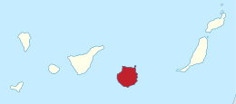
Gran Canaria is located in the Atlantic Ocean in a region known as Macaronesia about 150 kilometres (93 mi) off the northwestern coast of Africa and about 1,350 km (840 mi) from Europe.[5] With an area of 1,560 km2 (602 sq. mi)[6] and an altitude of 1,956 m (6,417 ft) at Morro de la Agujereada, Gran Canaria is the third largest island of the archipelago in both area and altitude. Gran Canaria is also the third most populated island in Spain.[7]
History
In antiquity, Gran Canaria was populated by the North African Canarii, who may have arrived as early as 500 BC.[8] In the medieval period, after over a century of European incursions and attempts at conquest, the island was conquered on April 29, 1483, by the Crown of Castile, under Queen Isabella I. The conquest succeeded after a campaign that lasted five years, and it was an important step towards the expansion of the unified Spain.
The capital city of Las Palmas de Gran Canaria was founded on June 24, 1478, under the name "Real de Las Palmas", by Juan Rejón, head of the invading Castilian army. In 1492, Christopher Columbus anchored in the Port of Las Palmas (and spent some time on the island) on his first trip to the Americas. Las Palmas de Gran Canaria is, jointly with Santa Cruz de Tenerife, the capital of the autonomous community of the Canary Islands.
Etymology
Pliny claimed that the island was called this way for the dogs on the island, of which two were presented as a gift to Juba, King of Mauretania.[9] This opinion is disputed as when the Europeans arrived on the island, no dogs were found.[9] An other source suggested the way the natives ate fish was dog like and this was the reason for its name.[9] A more plausible assumption is that the islands name derives from the people Canario or Canarii living near the Atlas mountain range.[10] Jean de Béthencourt named the island Gran Canaria as the people on the island were valorous opponents to his conquest.[10] The Canarii called the island Tamarán ('land of the brave").
Geography
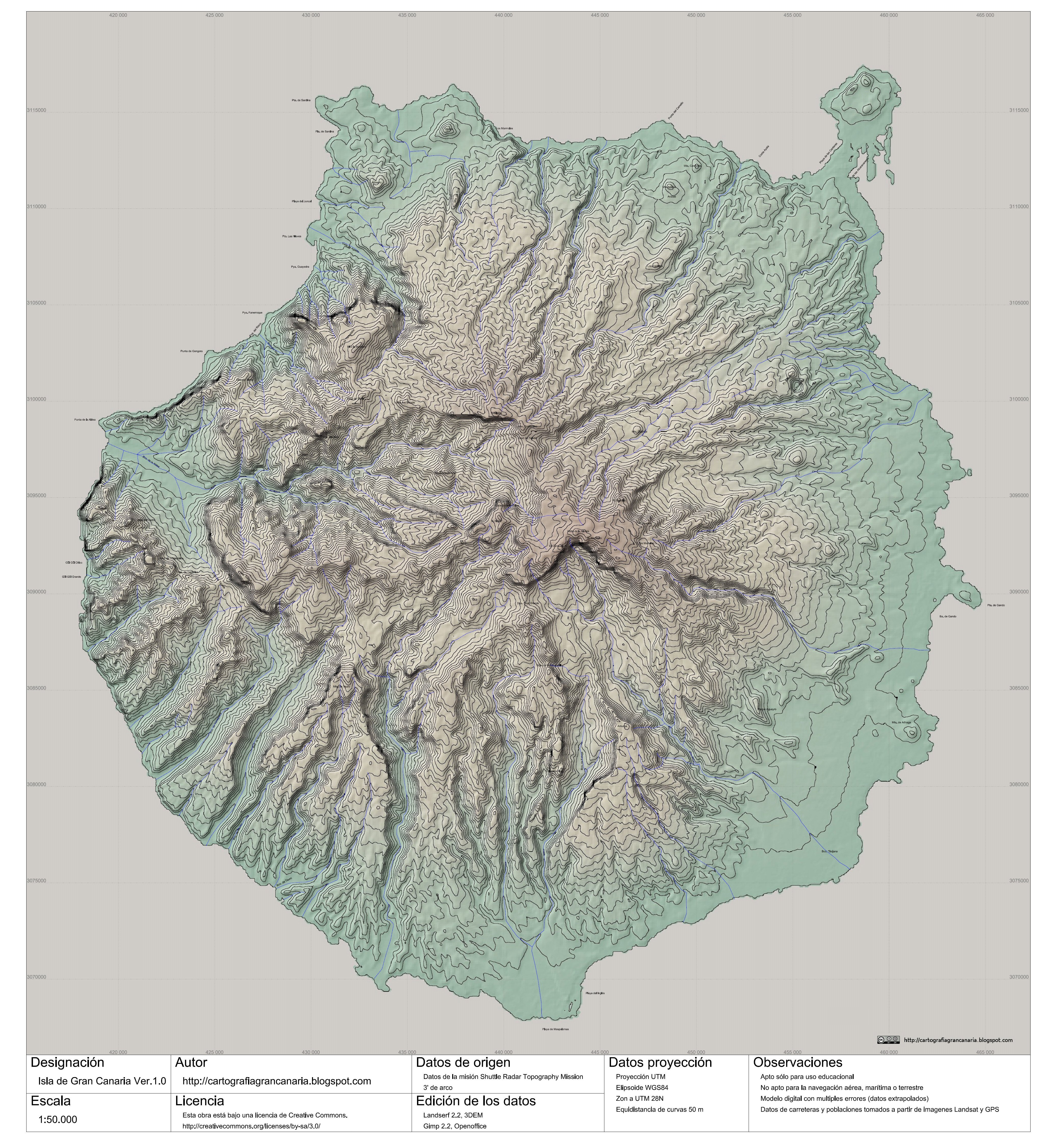

Gran Canaria is located in the Canary Islands archipelago southeast of Tenerife and west of Fuerteventura. The island is of volcanic origin, mostly made of fissure vents. It has a round shape, with a diameter of approximately 50 km (31 mi) and a surface area of 1,560 km2 (600 sq mi). Gran Canaria's maximum elevation is 1,956 metres (6,417 ft) at Morro de la Agujereada, although the nearby Pico de las Nieves has traditionally been considered the island's tallest peak.
Geology
About 80% of the volume of the island was formed during the Miocene period eruptions, between 14 and 9 million years ago.[11] This is called the "Old Cycle" and is estimated to have lasted some 200,000 years and have emitted about 1,000 km3 (240 cu mi), mostly of fissural alkali basalt. This cycle continued with the emission of trachytes, phonolites and peralkaline rocks.[12] This period was followed by one of erosion, which lasted some 4 million years.[13]
A second cycle of volcanic eruptions, known as the "Roque Nublo cycle", took place between 4.5 and 3.4 million years ago. This shorter cycle emitted about 100 km3 (24 cu mi). Most of the inland peaks were formed by erosion from these materials. This period also started with fissural basalts, but ended with violent eruptions of pyroclastic flows. Some phonolitic features, like the Risco Blanco, were also formed in its last stages.[13]
The third or recent cycle is held to have started some 2.8 million years ago and is considered to be still active. The last eruptions are held to have occurred some 2000 years ago.[14]
The changes in volume and, therefore, weight of the island have also caused the island to rise above the previous sea level during erosive periods and to sink during eruptive periods. Some of these "fossil beaches" can be seen in the cliff faces of the more eroded northern coast.[15]
 Nature of Gran Canaria along the eastern shore in 2016
 Nature of Gran Canaria along the southeastern shore in 2016


Vegetation
Until the conquest, Gran Canaria had extensive forests, but then suffered extensive deforestation[16] as a result of continuous logging, land divisions and other intensive uses. This reduced the forest cover to just 56,000 hectares (140,000 acres),[16] making the island the most deforested of the Canary Islands.[17] However, in the twentieth century reforestation of the ridge of the island was begun, recovering some of the lost forest mass. Much of the summit of the island is forested mostly due to reforestation.[16]
Governance
Gran Canaria is in the autonomous community of the Canary Islands (Islas Canarias). It lies within the Province of Las Palmas, a Spanish province which consists of the eastern part of the Canary Islands community. Las Palmas de Gran Canaria is the provincial capital, one of the two capitals of the Canary Islands along with Santa Cruz de Tenerife.[18]
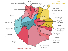
The island of Gran Canaria is governed by the Cabildo insular de Gran Canaria.[19] Gran Canaria Island itself is divided into twenty-one smaller municipalities:[18]
| Name | Area (km2) |
Population (2001)[20] |
Population (2011)[21] |
Population (2019)[22] |
|---|---|---|---|---|
| Agaete | 45.50 | 5,202 | 5,735 | 5,586 |
| Agüimes | 79.28 | 20,124 | 29,641 | 31,619 |
| Artenara | 66.70 | 1,319 | 1,252 | 1,069 |
| Arucas | 33.01 | 32,466 | 36,771 | 38,138 |
| Firgas | 15.77 | 6,865 | 7,606 | 7,455 |
| Gáldar | 61.59 | 22,154 | 24,358 | 24,242 |
| Ingenio | 38.15 | 24,439 | 30,022 | 31,321 |
| Mogán | 172.44 | 12,444 | 22,847 | 20,072 |
| Moya | 31.87 | 8,137 | 8,043 | 7,696 |
| La Aldea de San Nicolás | 123.58 | 7,668 | 8,522 | 7,504 |
| Las Palmas de Gran Canaria | 100.55 | 354,863 | 381,271 | 379,925 |
| San Bartolomé de Tirajana | 333.13 | 34,515 | 53,440 | 53,443 |
| Santa Brígida | 23.81 | 17,598 | 18,878 | 18,263 |
| Santa Lucía de Tirajana | 61.56 | 47,652 | 66,725 | 73,328 |
| Santa María de Guía de Gran Canaria | 42.59 | 13,893 | 14,149 | 13,850 |
| Tejeda | 103.30 | 2,400 | 2,136 | 1,909 |
| Telde | 102.43 | 87,949 | 101,080 | 102,647 |
| Teror | 25.70 | 12,042 | 12,857 | 12,519 |
| Valleseco | 22.11 | 3,949 | 3,896 | 3,749 |
| Valsequillo de Gran Canaria | 39.15 | 7,964 | 9,118 | 9,340 |
| Vega de San Mateo | 37.89 | 6,979 | 7,737 | 7,556 |
| Totals | 1,560.11 | 730,622 | 846,084 | 851,231 |
The island has a population at the start of 2019 of 851,231 with 379,925 of those in the capital city of Las Palmas de Gran Canaria. Gran Canaria is the second most populous island of the Canary Islands, after Tenerife.[23]
Transportation
Roads


Gran Canaria has roads encircling the whole island and extending into the mountain areas. In the late 20th century, its dual carriageway, among the first in the Canary Islands, were opened and run around Las Palmas de Gran Canaria, and were later extended to the north coast and the airport and subsequently to the south coast in response to increased tourist traffic. The only highway of Gran Canaria are GC1. Dual carriageway is GC2, and GC31, GC4 and GC5. The western and the north-western parts, with the fewest inhabitants, are linked only with main roads.
Buses
Public transport around Gran Canaria is provided by an extensive bus network, known in the local dialect as guaguas. The Autoridad Única del Transporte de Gran Canaria (Gran Canaria Transport Authority, TGC) manages the network and operates a number of bus stations across the island, including San Telmo and Santa Catalina bus stations in Las Palmas, Maspalomas and Galdar.[24] Bus tickets may be purchased with cash, and AUTGC also operates a contactless electronic ticket called the TransGC Card, which is valid across the whole network.[25]
Inter-urban bus services across the island are operated by the Global bus company.[26][27] Global was created in 2000 after the merger of two bus companies, Utinsa (which operated in the north of the island) and Salcai (the bus operator for the south).[28] Local bus services in Las Palmas are run by the municipal bus company, Guaguas Municipales de Las Palmas de Gran Canaria.[29]
Airport
Gran Canaria Airport (IATA: LPA) is the only commercial airport on the island. The large number of aircraft and passengers passing through it each year make it one of the busiest in Spain. Gran Canaria is also responsible for all air traffic control in the Canaries. By destination island, Gran Canaria is the second island that congregates the largest number of passengers in the Canary Islands.[30]
Sea ports
The most important ports in the island are the Port of Las Palmas (Puerto de la Luz), in the city of Las Palmas de Gran Canaria; Arguineguín, which exports cement from a large factory; and Arinaga, located in the main industrial zone of Canaries and one of the major ones of Spain.
The main passenger ports are the Port of La Luz, where Trasmediterránea operates a weekly ferry route to Cadiz on the Spanish mainland,[31] and the Port of Las Nieves, located in Agaete on the west side of the island, where Fred Olsen Express operates a catamaran ferry service to Santa Cruz de Tenerife.[32]
Train
Plans for a Tren de Gran Canaria railway network linking the capital with the south have been approved by both the Gran Canaria Cabildo and the autonomous Canary Islands' Government, though the discussion with the central Spanish Government hinges now on budget. The planned 57 km (35 mi) railway line would run between Las Palmas and Meloneras, with the section in the capital running entirely underground as far as the suburb of Jinámar. The line is planned to have 11 stations, including an underground station at Gran Canaria Airport. The scheme was first announced in 2009, with a planned operational date in 2015. A public company called Ferrocarriles de Gran Canaria has been formed by the Cabildo's Gran Canaria Transport Authority. Plans were still being discussed in 2018.[33][34]
Climate
According to the Köppen climate classification, Gran Canaria is considered to have a desert climate (Bwh) due to its severe lack of precipitation. Gran Canaria has consistent warm temperatures in spring, summer and autumn, and mild winters. Gran Canaria is noted for its rich variety of microclimates. Generally speaking though, the average daytime high ranges from 20 °C (68 °F) in winter to 26 °C (79 °F) in summer. Some cool nights occur in winter, but lows below 10 °C (50 °F) are unknown near the coast. Inland the climate is still mild but mountainous areas see the occasional frost or snow. Annual rainfall averages 228 mm (9.0 in), most of this falling in the cooler months, with July, August and September normally rainless. Rainfall is unevenly distributed through the island with some areas being much drier than others. Cloud cover and sunshine is often quite variable during the cooler months, and there can be several rather cloudy days at times in winter. Summers are generally quite sunny however, with the south of the island being most favoured.
| Climate data for Gran Canaria Airport (1981–2010 normals, 1951-2022 extremes), altitude: 32 m (105 ft) | |||||||||||||
|---|---|---|---|---|---|---|---|---|---|---|---|---|---|
| Month | Jan | Feb | Mar | Apr | May | Jun | Jul | Aug | Sep | Oct | Nov | Dec | Year |
| Record high °C (°F) | 29.5 (85.1) |
30.9 (87.6) |
34.0 (93.2) |
34.3 (93.7) |
36.0 (96.8) |
36.9 (98.4) |
44.2 (111.6) |
39.0 (102.2) |
39.0 (102.2) |
36.0 (96.8) |
36.2 (97.2) |
29.4 (84.9) |
44.2 (111.6) |
| Average high °C (°F) | 20.8 (69.4) |
21.2 (70.2) |
22.3 (72.1) |
22.6 (72.7) |
23.6 (74.5) |
25.3 (77.5) |
26.9 (80.4) |
27.5 (81.5) |
27.2 (81.0) |
26.2 (79.2) |
24.2 (75.6) |
22.2 (72.0) |
24.2 (75.5) |
| Daily mean °C (°F) | 17.9 (64.2) |
18.2 (64.8) |
19.0 (66.2) |
19.4 (66.9) |
20.4 (68.7) |
22.2 (72.0) |
23.8 (74.8) |
24.6 (76.3) |
24.3 (75.7) |
23.1 (73.6) |
21.2 (70.2) |
19.2 (66.6) |
21.1 (70.0) |
| Average low °C (°F) | 15.0 (59.0) |
15.0 (59.0) |
15.7 (60.3) |
16.2 (61.2) |
17.3 (63.1) |
19.2 (66.6) |
20.8 (69.4) |
21.6 (70.9) |
21.4 (70.5) |
20.1 (68.2) |
18.1 (64.6) |
16.2 (61.2) |
18.1 (64.5) |
| Record low °C (°F) | 8.0 (46.4) |
7.5 (45.5) |
6.5 (43.7) |
9.0 (48.2) |
11.3 (52.3) |
12.0 (53.6) |
14.8 (58.6) |
16.0 (60.8) |
14.6 (58.3) |
14.0 (57.2) |
7.0 (44.6) |
9.7 (49.5) |
6.5 (43.7) |
| Average precipitation mm (inches) | 25 (1.0) |
24 (0.9) |
13 (0.5) |
6 (0.2) |
1 (0.0) |
0 (0) |
0 (0) |
0 (0) |
9 (0.4) |
16 (0.6) |
22 (0.9) |
31 (1.2) |
151 (5.9) |
| Average precipitation days (≥ 1 mm) | 3 | 3 | 2 | 1 | 0 | 0 | 0 | 0 | 1 | 2 | 4 | 5 | 21 |
| Mean monthly sunshine hours | 184 | 191 | 229 | 228 | 272 | 284 | 308 | 300 | 241 | 220 | 185 | 179 | 2,821 |
| Source: Agencia Estatal de Meteorología[35][36] | |||||||||||||
Agriculture
Gran Canaria agriculture is unique among the Canaries islands in that it was traditionally dominated by plantations, with much of these being grains as well as sugarcane, rather than by stock-breeding.[37] The caves of Valerón (a property of cultural interest in the "archaeological site" category) in the municipality of Santa María de Guía bears testimony of it by being the largest pre-Hispanic collective granary of the Canaries.
Tourism


This island is called a "miniature continent" due to the different climates and variety of landscapes found, with long beaches and dunes of white sand, contrasting with green ravines and picturesque villages.[38] A third of the island is under protection as a Biosphere Reserve by UNESCO.
The number of annual visitors was 3.6 million in 2014 (of which 450.000 Spaniards).[39] Most of the tourists visit the southern part of the island. The north tends to be cooler, while the south is warmer and sunny. The east coast of the island is flat, dotted with beaches, while the western coast is rockier and mountainous.
The island possesses 32 Natural Protected Spaces,[40] notably the Rural Park of Nublo, The Doramas Jungle, the Azuaje Ravine, Tamadaba, Pino Santo, etc.
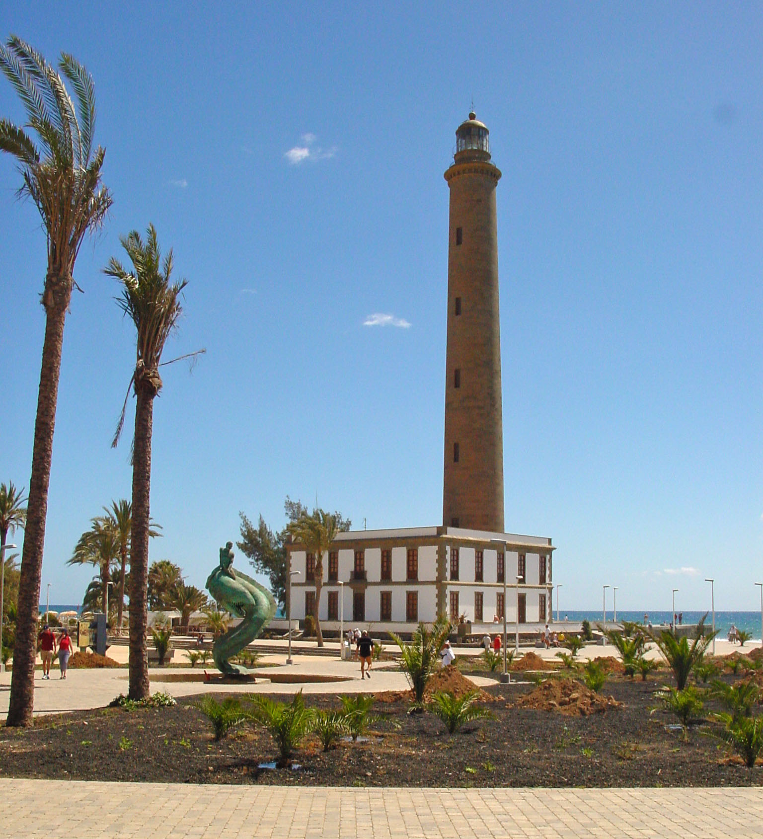
In the south there is a large bird park, Palmitos Park, as well as many beach resort communities. Resorts are concentrated in the central eastern part of the southern coast in the Maspalomas area, which includes the towns of San Agustín, Playa del Inglés and Meloneras. The Maspalomas Dunes are located between Playa del Inglés ("The Englishman's Beach") and the distinctive 19th century Maspalomas lighthouse. Playa del Ingles is home to the Yumbo Centre,[41] which was opened in 1982 and has almost 200 shops, including bars, restaurants, cafes, fashion boutiques, electronic outlets and jewellery stores.
In Tarajalillo, an Aeroclub exists from where tourist flights can be taken over the island.
Still further to the west along the southern shore, in the Municipality of Mogán, are the communities of Puerto Rico and Puerto de Mogán, a village referred to as "Little Venice" on account of its many canals.
Other attractions include Cocodrilos Park, Roque Nublo (an 80 m monolith), Cenobio de Valerón with more than 350 storage cavities, Painted cave of Galdar the most important archaeological park in Canary Islands, or the botanical gardens Jardín Canario (in Tafira Alta) and Cactualdea (in La Aldea de San Nicolás).
El Dedo de Dios, or "God's Finger", was a rocky spire jutting from the sea in Puerto de las Nieves, and was previously the signature attraction of the Canary Islands until it was destroyed by tropical storm Delta that crossed the archipelago in November 2005.[42]
Other well-known rock formations are El Cura (also known as El Fraile), The Frog (La Rana), Roque Bentayga, the Roque de Gando, and the Peñón Bermejo. Traditionally, the highest peak of the island has been considered to be the Pico de las Nieves, at 1,949 metres (6,394 ft); however, Morro de la Agujereada is taller, at 1,956 metres (6,417 ft).
The capital city is Las Palmas de Gran Canaria. Las Canteras beach, a protected area and diving zone, lies in the heart of the city. Las Palmas de Gran Canaria is also known for its annual carnaval. It was the first stop of Christopher Columbus' expedition on his way back from the Americas,[43] a commemoration of which is the Hermitage of San Antonio Abad, where the navigator prayed, and the Casa de Colón. Other attractions in the capital city include the Museo Canario (the most important archaeology museum in the archipelago), the cathedral and the Plaza del Espíritu Santo. In Teror the shrine of Virgen del Pino ("Virgin of the Pine"), patron saint of Gran Canaria, can be found. Its feast is celebrated on September 8.
The town of Agüimes, on the eastern part of the island, has been carefully restored and its town centre, centered on its old church and a peaceful square, now evokes the quiet living of a traditional Canarian town. The district also has some of the best preserved cave dwellings, in the protected area of the Guayadeque ravine, where even the church has been built into the mountainside and visitors can find a number of popular cave restaurants. The district also includes the most renowned scuba diving area on the island: the marine reserve at the playa de El Cabrón just outside the town of Arinaga.
Other important towns are Telde, known among other things for their surf schools in Salinetas, Vecindario (within the municipality of Santa Lucía de Tirajana) and Gáldar, that contains an important diving zone. In Arucas there is a Neogothic temple, popularly known as "Arucas' Cathedral", as well as a large fertile plain where bananas are grown. In Gáldar and its surroundings there is also a banana-growing plain and some remarkable archaeological remains,[44] such as the Painted cave of Galdar or the cenobio de Valerón's communal silos, ancient tombs (among which the necropolis of Maipés), and the port of Sardina del Norte (one of the island's ports where, as in Las Palmas', Christopher Columbus used to get supplies for his ships).
Heading west along the southern coast is the fishing city of Arguineguín in the Municipality of Mogán.
Natural symbols
The official natural symbols associated with Gran Canaria are Canary Mastiff and Euphorbia canariensis (Cardón)[45]
 Canary Mastiff


Beaches
- Playa de Maspalomas
- Playa de Meloneras
- Playa de las Canteras
- Playa Dedo de Dios
- Playa de Güi Güi
- Playa de Amadores
- Playa de Tufia y Aguadulce
- Playa de Tiritaña
Protected natural areas

Nearly half of the island territory — 667 km2 (258 sq mi) (42.7% of island) — is under protection from the Red Canaria de Espacios Naturales Protegidos (Canary Islands Network for Protected Natural Areas). Of the 146 protected sites under control of network in the Canary Islands archipelago,[46] a total of 33 are located in Gran Canaria, the second most protected island in the group. [47] There are seven different categories of protection:
- Six nature reserves — El Brezal, Azuaje, Los Tilos de Moya, Los Marteles, Las Dunas de Maspalomas and Güigüi (total 7,153.1 ha)
- Two integral nature reserves — Inagua and Barranco Oscuro (total 3,955,5 ha)
- Two natural parks — Tamadaba and Pilancones (total 13,333 ha)
- Two rural parks — Nublo and Doramas (total 29,893.4 ha)
- Ten natural monuments — Amagro, Bandama, Montañón Negro, Roque de Aguayro, Tauro, Arinaga, Barranco de Guayadeque, Riscos de Tirajana, Roque Nublo and Barranco del Draguillo (total 5,264.9 ha)
- Seven protected landscapes — La Isleta (in the capital Las Palmas de Gran Canaria), Pino Santo, Tafira, Las Cumbres, Lomo Magullo, Fataga and Montaña de Agüimes (total 12,680.9 ha)
- Four sites of scientific interest — Jinámar, Tufia, Roque de Gando and Juncalillo del Sur (total 276.2 ha).[40]
Music
- Phalmuter (2006−present), a Spanish heavy metal/hard rock band from Gran Canaria.
Science and technology
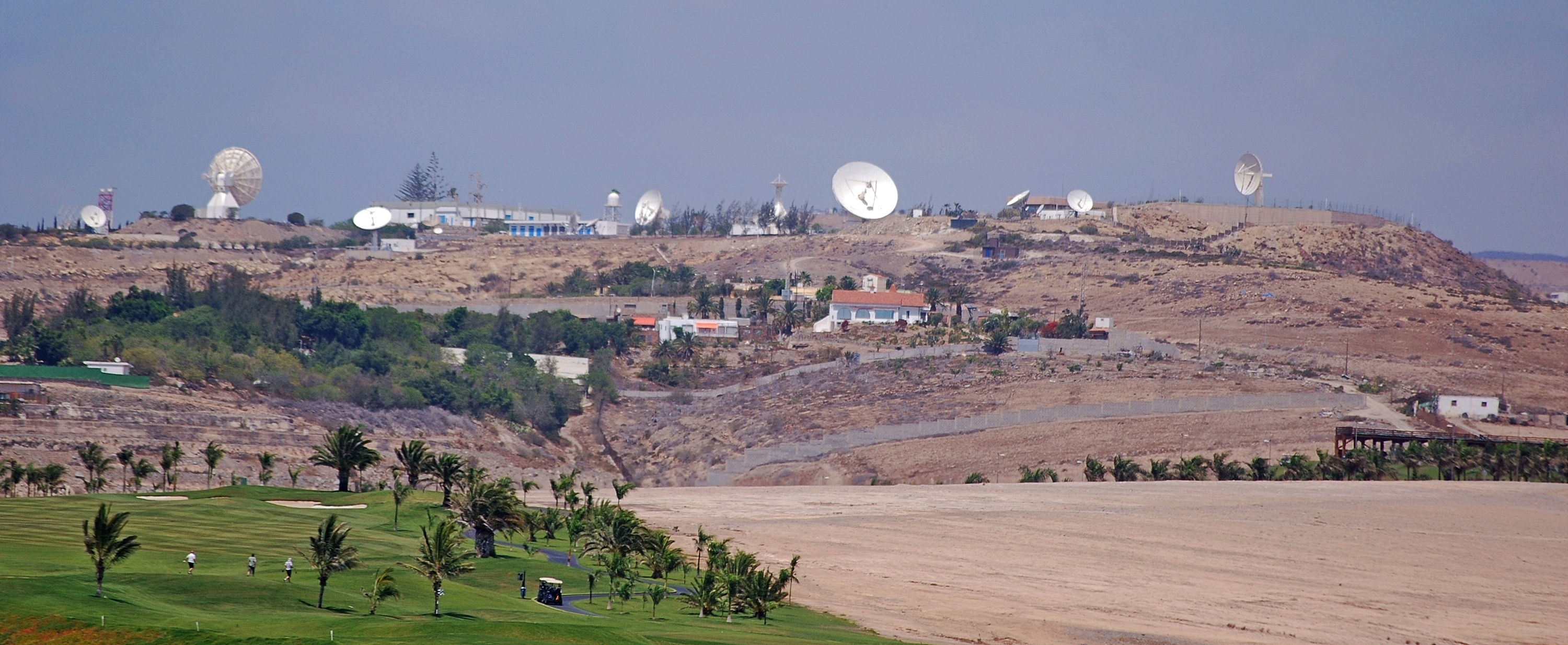
In the 1960s, Gran Canaria was selected as the location for one of the 14 ground stations in the Manned Space Flight Network (MSFN) to support the NASA space program. Maspalomas Station, located in the south of the island, took part in a number of space missions including the Apollo 11 Moon landings and Skylab. Today it continues to support satellite communications as part of the ESA network.[48]
Sports

The island is home to CB Gran Canaria – a basketball club playing in Liga ACB at the Gran Canaria Arena, with a capacity of 11,000. The island is also home to UD Las Palmas – a football club playing in Segunda División at the Estadio de Gran Canaria, with a capacity of 32,392.
See also
- Zona franca de las Palmas de Gran Canaria
Bibliography
- Andrews, Sarah; Quintero, Josephine (2007). Canary Islands. Lonely Planet. ISBN 978-1741045956.
Geology of Gran Canaria
- Carracedo, Juan Carlos; Day, Simon (2002). Canary Islands. Terra (Harpenden). ISBN 978-1741045956., pp. 97–136
References
- Population referred to the January 1, 2019 Archived 31 January 2019 at the Wayback Machine
- Wells, John C. (2008). Longman Pronunciation Dictionary (3rd ed.). Longman. ISBN 978-1-4058-8118-0.
- Roach, Peter (2011). Cambridge English Pronouncing Dictionary (18th ed.). Cambridge: Cambridge University Press. ISBN 978-0-521-15253-2.
- Population referred to the January 1, 2018 Archived 31 January 2019 at the Wayback Machine
- Situación y Clima. Ayuntamiento de Las Palmas de Gran Canaria. Archived 2010-06-29 at the Wayback Machine
- ISTAC: Estadísticas de la Comunidad Autónoma de Canarias Archived 2010-11-14 at the Wayback Machine (Statistics for the Canaries) on gobiernodecanarias.org.
- "Boletín Oficial del Estado" (PDF). 29 December 2018.
- Troll, Valentin R.; Rodriguez-Gonzalez, Alejandro; Deegan, Frances M.; Perez-Torrado, Francisco José; Carracedo, Juan Carlos; Thomaidis, Konstantinos; Geiger, Harri; Meade, Fiona C. (March 2019). "Sacred ground; the Maipés necropolis of north-west Gran Canaria". Geology Today. 35 (2): 55–62. doi:10.1111/gto.12262. S2CID 134369618.
- Glas, Gregor (2010). The History of the discovery of the discovery and conquest of the Canary Islands. Canary Islands. p. 87. ISBN 9788461418534.
- Glas, Gregor (2010), p.88
- Carracedo, Juan Carlos; Troll, Valentin R. (2021-01-01). "North-East Atlantic Islands: The Macaronesian Archipelagos". Encyclopedia of Geology. pp. 674–699. doi:10.1016/B978-0-08-102908-4.00027-8. ISBN 9780081029091. S2CID 226588940.
- "The Geology of the Canary Islands - 1st Edition". www.elsevier.com. Retrieved 2020-10-19.
- Araña, V and Carracedo, J.C: Canarian Volcanoes, Volume 3: Gran Canaria, pp. 8, 24. Editorial Rueda, Madrid, 1978.
- "The Geology of the Canary Islands - 1st Edition". www.elsevier.com. Retrieved 2021-09-07.
- Oscillations of up to 400 m (1,300 ft) in the level corresponding to sea level have occurred in geological history. The highest point known is in the Bay of El Confital, Las Palmas (130 m, 430 ft above current sea level) while subaerial materials have been extracted from a well at 230 m (750 ft) below sea level in the area of La Aldea. Araña, V and Carracedo, J.C: Canarian Volcanoes, Volume 3: Gran Canaria, pp. 13. Editorial Rueda, Madrid, 1978.
- Reforestación de las cumbres de Gran Canaria
- “Con lo que cuesta un Jumbo se puede reforestar toda Gran Canaria”
- "Government of Gran Canaria". www.spain-grancanaria.com. Retrieved 21 November 2018.
- "Historia del Cabildo - Cabildo de Gran Canaria". cabildo.grancanaria.com (in European Spanish). Retrieved 21 November 2018.
- Census at 1 November 2001: Instituto Nacional de Estadística, Madrid.
- Census at 1 November 2011: Instituto Nacional de Estadística, Madrid.
- Estimate at 1 January 2019: Instituto Nacional de Estadística, Madrid.
- Population referred to the January 1, 2018 Archived 31 January 2019 at the Wayback Machine
- "Intercambiadores y Paradas Preferentes | Autoridad Única del Transporte de Gran Canaria". www.autgc.org (in Spanish). Autoridad Única del Transporte de Gran Canaria. Archived from the original on 2018-11-20. Retrieved 2018-11-20.
- "Tarjeta TransGC". www.autgc.org (in Spanish). Autoridad Única del Transporte de Gran Canaria. Retrieved 20 November 2018.
- "Gran Canaria - Global SU". Global SU. Retrieved 20 November 2018.
- "Líneas y Horarios". Global SU (in European Spanish). Retrieved 30 January 2019.
- "La Empresa: Global". Global (in European Spanish). Retrieved 30 January 2019.
- "Guaguas Municipales | Quiénes somos". Guaguas Municipales (in Spanish). Retrieved 30 January 2019.
- "Entrada en los aeropuertos canarios según islas". Archived from the original on 13 November 2010.
- "Cadiz to Las Palmas ferry tickets, compare times and prices". www.directferries.co.uk. Retrieved 20 November 2018.
- "Agaete to Santa Cruz de Tenerife ferry tickets, compare times and prices". www.directferries.co.uk. Retrieved 20 November 2018.
- "Gran Canaria train details announced - Gran Canaria - Gran Canaria - ISLANDCONNECTIONS.EU". Island Connections. Archived from the original on 12 November 2018. Retrieved 12 November 2018.
- "Estado y Cabildo pactan cerrar los proyectos del tren en 2018". www.canarias7.es (in European Spanish). Retrieved 12 November 2018.
- "Standard Climate Values. Gran Canaria Aeropuerto".
- "Extreme values. Gran Canaria Aeropuerto". AEMET. Retrieved 12 February 2022.
- Cenobio de Valeron, section "El yacimiento arqueologico". On arqueologiacanaria.com.
- Gran Canaria – Official Canary Islands Tourism
- "Situation Of The Tourism Sector, Year Ending 2014". The Official Gran Canaria Tourist Website. Cabildo de Gran Canaria. Archived from the original on 10 February 2017. Retrieved 12 March 2016.
- "Espacios Naturales Protegidos de Gran Canaria Font: Gobierno de Canarias". Archived from the original on 2007-03-23. Retrieved 2007-03-14.
- "Yumbo Centre - Maspalomas - Gran Canaria". Archived from the original on 2020-01-19. Retrieved 2018-07-26.
- BBC NEWS - Tropical Storm Delta batters Canaries.
- Andrews & Quintero 2007, p. 29.
- Interactive map of Heritage sites on Grand Canary island Archived 2016-08-18 at the Wayback Machine. On estodotuyo.com, site on Heritage assets by the council of Grand Canary.
- Ley 7/1991, de 30 de abril, de símbolos de la naturaleza para las Islas Canarias
- Red Canaria de Espacios Naturales Protegidos Archived 2016-11-21 at the Wayback Machine
- "Relación de los Espacios Naturales protegidos de Gran Canaria". Archived from the original on 2007-03-23. Retrieved 2007-03-14.
- "Maspalomas station". European Space Agency. Archived from the original on 8 February 2019. Retrieved 8 February 2019.
External links
- Gran Canaria Tourist Board official site Archived 2013-12-24 at the Wayback Machine
 Gran Canaria travel guide from Wikivoyage
- "Gran Canaria". Global Volcanism Program. Smithsonian Institution. Retrieved 2021-06-26.
| |||||||||
| Governance |
|   | |||||||
| Municipalities |
| ||||||||
| History |
| ||||||||
| Nature |
| ||||||||
| Landmarks and attractions |
| ||||||||
| Transport |
| ||||||||
| Sport |
| ||||||||
| Education and science |
| ||||||||
Islands and provinces of the Canary Islands | ||
|---|---|---|
| Main islands |  | |
| Other islands | ||
| Provinces | ||
Authority control | |
|---|---|
| General | |
| National libraries | |
| Other | |
На других языках
[de] Gran Canaria
Gran Canaria ist mit einer Fläche von 1560,1 km² nach Teneriffa und Fuerteventura die drittgrößte der Kanarischen Inseln, einer Autonomen Gemeinschaft Spaniens. Die annähernd kreisförmige Insel hat einen Durchmesser von etwa 50 Kilometern und eine Küstenlänge von rund 236 Kilometern. Gemessen an der Bevölkerung ist Gran Canaria nach Teneriffa die zweitgrößte Insel der Kanaren. Die Hauptstadt ist Las Palmas de Gran Canaria. Im Jahr 2020 hatte die Insel 855.521 Einwohner.- [en] Gran Canaria
[es] Gran Canaria
Gran Canaria es una isla situada en el océano Atlántico, perteneciente a la Comunidad Autónoma de Canarias en España. Junto con las islas de Lanzarote, Fuerteventura y La Graciosa forman la provincia de Las Palmas, integrada además por los islotes de Alegranza, Montaña Clara, Roque del Este, Roque del Oeste e Islote de Lobos. Gran Canaria con una superficie de 1560,1 km²[5] y una altitud de 1956 metros con el Morro de la Agujereada,[2] es la tercera isla del archipiélago en extensión[6] y altitud.[7][fr] Grande Canarie
La Grande Canarie, en espagnol Gran Canaria, est une île d'Espagne située dans l'océan Atlantique et faisant partie des îles Canaries. Deuxième île la plus peuplée de cet archipel[2], la plus grande ville, Las Palmas de Grande Canarie, est aussi la capitale de la province de Las Palmas et cocapitale avec Santa Cruz de Tenerife de la communauté autonome des îles Canaries. En outre, Las Palmas de Gran Canaria est la plus grande ville des îles Canaries et forme l'une des dix zones métropolitaines les plus peuplées d'Espagne[3].[it] Gran Canaria
Gran Canaria è una delle Isole Canarie, di origine vulcanica, terza[1] isola per dimensione nella Macaronesia e seconda isola più popolata dell'arcipelago[2][3], essendo la sua capitale, Las Palmas de Gran Canaria, la più grande città e area metropolitana delle Isole Canarie ed è tra le dieci grandi aree metropolitane della Spagna (700 mila abitanti)[4]. Politicamente condivide lo status di capoluogo delle Isole Canarie con Santa Cruz de Tenerife in cui ha sede il parlamento locale, mentre a Las Palmas de Gran Canaria si trova la sede del governo spagnolo nelle Isole Canarie. Gran Canaria con una superficie di 1.560,1 km[5] quadrati e un'altezza massima di 1956 metri[6] con il Pico de las Nieves, è la terza isola più grande dell'arcipelago per estensione e altitudine.[ru] Гран-Канария
Гран-Кана́рия (исп. Gran Canaria) — один из Канарских островов, третий по величине (площадь 1560,1 км²) в архипелаге после островов Тенерифе и Фуэртевентура. На 2012 год население острова составило 852 225 человек, что делает Гран-Канарию вторым среди Канарских островов по количеству жителей. Столицей Гран-Канарии является город Лас-Пальмас-де-Гран-Канария, административный центр одноимённой провинции.Другой контент может иметь иную лицензию. Перед использованием материалов сайта WikiSort.org внимательно изучите правила лицензирования конкретных элементов наполнения сайта.
WikiSort.org - проект по пересортировке и дополнению контента Википедии