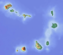
geo.wikisort.org - Island
Boa Vista (Portuguese for "good view"), also written as Boavista, is a desert-like island that belongs to the Cape Verde Islands. At 631.1 km2 (243.7 sq mi),[1] it is the third largest island of the Cape Verde archipelago.
Nickname: Ilha das dunas (island of the dunes) | |
|---|---|
 | |
 | |
 Boa Vista  Boa Vista | |
| Geography | |
| Location | Atlantic Ocean |
| Coordinates | 16°6′N 22°48′W |
| Archipelago | Cape Verde |
| Area | 631.1 km2 (243.7 sq mi) |
| Length | 30.8 km (19.14 mi) |
| Width | 28.9 km (17.96 mi) |
| Highest elevation | 387 m (1270 ft) |
| Highest point | Monte Estância |
| Administration | |
| Municipality | Boa Vista |
| Largest settlement | Sal Rei |
| Demographics | |
| Population | 14,451 (2015) |
| Pop. density | 22.9/km2 (59.3/sq mi) |
| Additional information | |
| Official website | www |
The island of Boa Vista is closer to the African continent than all the other islands in Cape Verde, being the easternmost island of all. The distance between Boa Vista and Senegal is only 450 km. The capital of Boa Vista, Sal Rei, is located in the north-western part of the island. Boa Vista is mainly known for its beaches, turtles and traditional music.
Geography

Boa Vista is the third largest island after Santo Antão and Santiago, with an area of 631.1 square kilometres.[1] It is situated south of Sal and north of Maio. The island is generally flat, but it has numerous hills like Monte Estância (the highest point of the island at 387 m),[2] Monte Santo António, Rocha Estância, Morro de Areia, Morro Negro, Monte Caçador, Pico Forcado and Monte Vigia.
Boa Vista is famous for its large beaches like Atalanta, Cabral, Chaves, Ervatão, Gatas, Santa Mónica and Varandinha. Its northernmost point is Ponta do Sol; its westernmost point Ponta Varandinha. Its main river is the Ribeira do Rabil, which has the largest basin area of all Cape Verde at 199 km2 (77 sq mi).[3]: 22 Boa Vista is also notable for its desert Deserto de Viana and its dune fields. Boa Vista is surrounded by a number of uninhabited islets, the largest of which is Ilhéu de Sal Rei.
History
The uninhabited island Boa Vista was discovered by António de Noli and Diogo Gomes in 1460.[4]: 72–73 Until the end of the 16th century the only human activity on the island was breeding wild cattle.[4]: 83 The island's first settlement, now known as Povoação Velha, was established in 1620 for its salt deposits, which were mainly exploited by the English.[5] In 1820, after many pirate attacks, the population moved to Porto Inglês, later renamed Sal Rei, which had been founded at the end of the 18th century.[6] As did much of the Cape Verdean economy, the exploitation of salt on Boa Vista also relied largely on slavery. A Portuguese-British commission to end slavery was established in Boa Vista in 1842, but slavery was not completely abolished until 1876.[7] Until 1935 the municipality of Boa Vista also covered the island of Sal.[8] In 1975, Cape Verde declared its independence.

Municipality
Administratively, the island of Boa Vista is covered by one municipality, Concelho da Boa Vista. This municipality consists of two freguesias (civil parishes): Santa Isabel and São João Baptista. The municipal seat is the city Sal Rei. The island's two parishes are subdivided into 9 population zones for statistical purposes:[9]
| Municipality | Concelho da Boa Vista | ||
|---|---|---|---|
| Freguesias | Santa Isabel | São João Baptista | |
| Zones |
|
|
|
Politics
Since 2016, the local party BASTA is the ruling party of the municipality. The results of the latest elections, in 2016:[11]
| Party | Municipal Council | Municipal Assembly | ||
|---|---|---|---|---|
| Votes% | Seats | Votes% | Seats | |
| BASTA | 57.56 | 5 | 53.08 | 7 |
| MpD | 30.60 | 0 | 30.23 | 4 |
| PAICV | 10.32 | 0 | 14.96 | 2 |
Population
In the 1830s, the population of Boa Vista was estimated at 4,000.[12] In 2015 Boa Vista's population was 14,451.[10]: 36 Most of the population live in Sal Rei, but there are also several smaller settlements with 10 to 100 people. With 23.3 inhabitants per km2, it is the least-dense populated island in the archipelago.[10]: 31
The population of Boa Vista consist of a mixture of different nationalities. The Creoles, of mixed mainland African and European descent are the biggest group of inhabitants, with no less than 70%, as a lot of Portuguese enter into a relation with the slaves of the African continent, during the colonization of Portugal, and settled in Boa Vista afterwards.
| Year | Population |
|---|---|
| 1940[13] | 2,779 |
| 1950[13] | 2,985 |
| 1960[13] | 3,263 |
| 1970[13] | 3,569 |
| 1980[13] | 3,372 |
| 1990[13] | 3,452 |
| 2000[13] | 4,193 |
| 2010[1] | 8,554 |
| 2015[10]: 36 | 14,451 |
Economy
Before, the inhabitants of Boa Vista survived off salt collection and date farming. Nowadays they still earn money from date farming but also from tourism. A lot of people do work in this touristic sector as a taxi driver, an employee in one of the hotel chains or as a salesman of souvenirs in Sal Rei. The income from tourism has risen rapidly since the coming of the international airport in 2007. There are several hotels and beach resorts on the island.
Transport
The airport of Boa Vista is Aristides Pereira International Airport, about 5 km southeast of Sal Rei. There are ferry services from the port of Sal Rei.
The island has 64 km of national roads,[14] the single first class national road connects Sal Rei and Rabil.[15]
Nature
Boa Vista is not as abundant in flora and fauna as the other larger or more humid islands such as Santiago and Santo Antão; only 3% of its area is forested.[3]: 25 However, 37% of its area is a protected area, which is the highest proportion of all inhabited Cape Verde islands.[3]: 24 There are 14 protected areas on Boa Vista, including beaches that are important nesting areas for loggerhead sea turtles and birds.[2] There are several endemic species, e.g. Boa Vista wall gecko (Tarentola boavistensis), Conus boavistensis, Conus salreiensis) and Plesiocystiscus bubistae.
Gallery
 Boa Vista landscape.
 Praia de Cabral, Boa Vista, Cape Verde
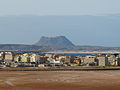 The capital, Sal Rei
 Ruins of the abandoned village Curral Velho.
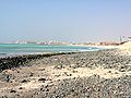 Sal Rei beach


Sports
There are several football clubs on Boa Vista, organised in the Boa Vista Regional Football Association.
Notable residents
- Aristides Pereira, Cape Verde's first president
- Germano Almeida, a Cape Verdean writer[16]
References
- 2010 Census Summary
- Protected areas in the island of Boa Vista - Municipality of Boa Vista, March 2013 (in Portuguese)
- Estatísticas do Ambiente - 2016, Instituto Nacional de Estatística
- Valor simbólico do centro histórico da Praia, Lourenço Conceição Gomes, Universidade Portucalense, 2008, p. 97
- Boa Vista, Municipality of Boa Vista
- Sal-Rei (Porto Inglês), Heritage of Portuguese Influence
- Lumumba H. Shabaka (2015). "Ending Slavery in Cabo Verde: Between Manumission and Emancipation, 1856-1876". Journal of Cape Verdean Studies. 2 (1): 109–132.
- Direito da Terra, Compêndio de Legislação, p. 272
- "2010 Census results Boa Vista". Instituto Nacional de Estatística Cabo Verde (in Portuguese). 24 November 2016.
- Cabo Verde, Statistical Yearbook 2015, Instituto Nacional de Estatística
- Official results local elections 2016 Archived 2019-08-19 at the Wayback Machine, Boletim Oficial I Série, Número 53, 23 September 2016
- Roberts, Edmund (1837). Embassy to the Eastern Courts of Cochin-China, Siam, and Muscat. New York: Harper & Brothers. p. 14.
- Source: Statoids
- "Instituto de Estradas de Cabo Verde, State of the National Roads in Cape Verde, 2017" (PDF). Archived from the original (PDF) on 2017-12-07. Retrieved 2017-12-07.
- Classification of National Roads (Santo Antão, São Vicente, São Nicolau, Sal, Boa Vista), Instituto de Estradas (in Portuguese)
- Educom.sce.fct.unl.pt Archived July 3, 2004, at the Wayback Machine
External links
| Island groups | ||
|---|---|---|
| Islands | ||
| Islets | ||
The island of Boa Vista | ||
|---|---|---|
| Santa Isabel |  | |
| São João Baptista | ||
| Mountains | ||
| Islets | ||
| Beaches | ||
| Other geographical features |
| |
| ||
Authority control | |
|---|---|
| General |
|
| National libraries | |
| Other |
|
На других языках
[de] Boa Vista (Kap Verde)
Boa Vista (deutsch: Schöner Ausblick), auch Boavista geschrieben, ist die drittgrößte der Kapverdischen Inseln im östlichen Zentralatlantik. Die Insel ist zugleich namensgebend für einen Landkreis (Concelho). Die „Perle“ der Kapverden genannte Wüsteninsel wird seit einiger Zeit als Touristenziel aufgebaut. Namhafte europäische Investoren haben in den letzten Jahren luxuriöse Ferienwohnungen und Hotels im maurischen Stil errichtet.[1] Die schönsten und längsten Strände der Kapverden sollen sich hier befinden.[2]- [en] Boa Vista, Cape Verde
[es] Isla de Boa Vista
Boavista (Bubista en criollo caboverdiano) es la isla más oriental de Cabo Verde, la tercera por extensión, perteneciente a las islas de Barlovento y un municipio de la misma en Cabo Verde. Su principal villa es Sal Rei (portugués por "sal rey").[fr] Boa Vista (Cap-Vert)
Boa Vista ou Boavista (belle vue en portugais), est une île de l'archipel des Îles de Barlavento au Cap-Vert. Cet archipel compte dix îles dont Boa Vista, qui est la troisième plus grande île.[it] Boa Vista (Capo Verde)
Boa Vista (che in portoghese significa Buona Vista) è un'isola di Capo Verde, appartenente al gruppo delle isole Barlavento. Il suo territorio appartiene completamente alla contea omonima.[ru] Боа-Вишта (остров)
Боа-Вишта[1][2], ранее — Боави́шта[3][4] (порт. Boa Vista — «прекрасный вид») — третий по величине остров в Кабо-Верде.Другой контент может иметь иную лицензию. Перед использованием материалов сайта WikiSort.org внимательно изучите правила лицензирования конкретных элементов наполнения сайта.
WikiSort.org - проект по пересортировке и дополнению контента Википедии