geo.wikisort.org - Coast
Mizen Head (Irish: Carn Uí Néid) is traditionally regarded as the most southerly point of mainland Ireland. It is at the end of the Mizen Peninsula in the district of Carbery in County Cork.
| Mizen Head | |
|---|---|
| Carn Uí Néid | |
 Mizen Head, the most southwesterly point of Ireland | |
| Highest point | |
| Elevation | 101.63 m (333.4 ft)[1] |
| Coordinates | 51°27′1″N 9°49′10″W |
| Naming | |
| Language of name | Irish |
| Geography | |
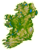
 Location in Ireland | |
| Location | County Cork, Ireland |
| OSI/OSNI grid | D180438 |
| Geology | |
| Mountain type | Dolerite sill |
Geography
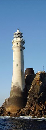
Mizen Head is one of the extreme points of the island of Ireland and is a major tourist attraction, noted for its dramatic cliff scenery. One of the main transatlantic shipping routes passes close by to the south, and Mizen Head was, for many seafarers, the first (or last) sight of Europe. The tip of the peninsula is almost an island, cut off by a deep chasm, now spanned by a bridge; this gives access to an old signal station, a weather station, and a lighthouse. The signal station, once permanently staffed, is now a museum housing displays relating to the site's strategic significance for transatlantic shipping and communications, including the pioneering efforts of Guglielmo Marconi. The "99 steps" which formed part of the original access route have been supplemented by a series of paths and viewing platforms, and a full range of visitor facilities is available at the entrance to the site. The villages of Ballydehob, Crookhaven, Goleen, and Schull are located on the peninsula to the east.

Nearby Brow Head, also on the Mizen Peninsula and a short distance to the east, is several metres further south than Mizen Head. Nevertheless, geography books have long measured the length of Ireland, diagonally northeast-to-southwest, as "from Fair Head to Mizen Head"[2] or north-to-south "from Malin Head to Mizen Head".[3]
History
Ptolemy's Geography (2nd century AD) referred to the point as the "southern headland" (Ancient Greek: Νότιον ἄκρον, romanized: Notion akron).[4][5]
The headland's Irish name, Carn Uí Néid, means "cairn of Néid's grandson". This refers to Balor, a leader of the Fomorians in Irish mythology. In a tale dating from at least the 12th century, the god Lugh defeats Balor in combat and chases him to Mizen Head. There, Lugh beheads Balor and sets the severed head on a large rock, which then shatters.[6]
See also
- Carbery's Hundred Isles
- Malin to Mizen
- Wild Atlantic Way
References
- "Mizen Head Elevation (101.63 M)". Distancesto.com. 2017.
elevation 101.63 m
- Robert Johnson. The Competitive Geography (1877). p. 170.
- William Hughes and John Williams. A Class-book of Modern Geography (1885). p. 78.
- Ptolemy. The Geography. Vol. 2.2.5.
-
 Smith, William, ed. (1854–1857). "Notium". Dictionary of Greek and Roman Geography. London: John Murray.
 - Ó hÓgáin, Dáithí (1991). Myth, Legend & Romance: An encyclopaedia of the Irish folk tradition. Prentice Hall. pp. 43–45. ISBN 9780132759595.
Sources
- Mizen Journal, Archaeology Paddy O'Leary, No 11, 2003 ISSN 1649-203X
- Archaeological Inventory of County Cork, Vol 1 West Cork, Office of Public Works, 1992 ISBN 0-7076-0175-4
- BHAS Journal vol 2 p.106-119, Townlands Donal Fitzgerald ISSN 0791-6612
- Northside of the Mizen, General reading, Patrick McCarthy & Richard Hawkes
External links
Peninsulas of Ireland | ||
|---|---|---|
Geography of Ireland / Coastal landforms of Ireland | ||
| Leinster |
|  |
| Ulster | ||
| Connacht |
| |
| Munster |
| |

Lighthouses in Ireland | ||
|---|---|---|
Lighthouses are shown in anti-clockwise sequence beginning from the north and proceeding west, south, east, and back to north. | ||
| County Donegal |
|  |
| County Sligo |
| |
| County Mayo |
| |
| County Galway |
| |
| County Clare |
| |
| County Kerry |
| |
| County Cork |
| |
| County Waterford |
| |
| County Wexford |
| |
| County Wicklow |
| |
| County Dublin |
| |
| County Louth |
| |
| County Down |
| |
| County Antrim |
| |
| ||
На других языках
[de] Mizen-Halbinsel
Die Mizen-Halbinsel (irisch Carn Uí Néid, englisch Mizen Head) ist die südlichste der vier südwestlichen Halbinseln Irlands und gehört zur Grafschaft Cork. Sie hat die Form zweier Finger, von denen der nördliche „Sheep’s Head“ (oder Muntervary, irisch Rinn Mhuintir Bháire) genannt wird und zu den abgeschiedensten Regionen der gesamten Insel gehört. Ringstraßen, an denen u. a. die winzigen Orte Crookhaven, Goleen, Schull und Toormore liegen, erschließen die zweigeteilte Halbinsel.- [en] Mizen Head
[es] Cabo Mizen
El cabo Mizen (en inglés: Mizen Head) en irlandés, Carn Uí Néid) se encuentra en el extremo occidental de la península Mizen en el distrito de Carbery en el punto más suroccidental de Irlanda, es uno de los puntos más extremos de la isla de Irlanda. Queda en el oeste del condado de Cork, República de Irlanda y es una atracción turística. Ubicada sobre el promontorio se encuentra una antigua estación de señalización, una estación meteorológica, y un faro. La estación de señalización, hoy un museo, está abierta a los visitantes. Los "99 escalones" son una largsa serie de escalones en el sendero al otro lado del afloramiento rocoso sobre el que fue construida la estación. Los pueblos de Ballydehob, Goleen y Schull se encuentran en la península. El cabo Mizen (Ceann Moiscne) en el condado de Wicklow se encuentra en el sur del cabo Wicklow.Другой контент может иметь иную лицензию. Перед использованием материалов сайта WikiSort.org внимательно изучите правила лицензирования конкретных элементов наполнения сайта.
WikiSort.org - проект по пересортировке и дополнению контента Википедии