geo.wikisort.org - Island
Dursey Island (Irish: Baoi Bhéarra or Oileán Baoi[2]) lies at the southwestern tip of the Beara Peninsula in the west of County Cork in Ireland. Dursey Island is 6.5 kilometres long and 1.5 kilometres wide. The island is separated from the mainland by a narrow stretch of water, Dursey Sound, which has a very strong tidal race, with the submerged Flag Rock close to the centre of the channel.
Native name: Oileán Baoi | |
|---|---|
 Dursey Island as seen from a hiking path on the mainland | |
 Dursey Island | |
| Geography | |
| Location | Beara Peninsula |
| Coordinates | 51°36′N 10°12′W |
| Area | 5.6 km2 (2.2 sq mi) |
| Length | 6.5 km (4.04 mi) |
| Width | 1.5 km (0.93 mi) |
| Highest elevation | 252 m (827 ft) |
| Administration | |
Ireland | |
| Province | Munster |
| County | Cork |
| Demographics | |
| Population | 4 (2016)[1] |
| Additional information | |
| Official website | DurseyIsland.ie |
The island has just six or so permanent residents, and is connected to the mainland by Ireland's only cable car. The cable car system is due to be closed for maintenance from April until November 2022,[3] during which period a temporary ferry is due to operate.[4]
Dursey has no shops, pubs or restaurants.[5] At one point there was a post office on the island; this has since closed.[2][6]
Geography and fauna
The townlands on the island are Ballynacallagh, Kilmichael, and Tilickafinna. There are three main peaks, the highest 252m.[7] The promontories and rocks off Dursey include:
Bull Rock
Off the western point of the island are three rocks: Bull Rock, Cow Rock and Calf Rock. Bull Rock Lighthouse, which stands on Bull Rock, was built in 1888 and automated in March 1991. Bull Rock was inhabited until this time.[8]
|
|
| ||||||||||||||||||||||||||||||||||||||||||||||||||||||||||||||||||||||||||||||
| Source: Central Statistics Office. "CNA17: Population by Off Shore Island, Sex and Year". CSO.ie. Retrieved 12 October 2016. | ||||||||||||||||||||||||||||||||||||||||||||||||||||||||||||||||||||||||||||||||
Calf Rock
A staffed lighthouse on Calf Rock was destroyed in a storm in 1881 and its remains can still be seen.[9]
Cow Rock
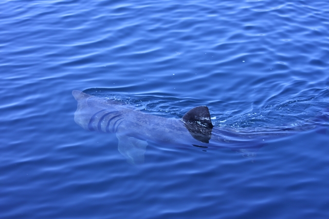
Cow Rock is home to a number of nesting colonies of seabirds. Dolphins, whales and basking shark are sometimes seen in the sea off the island.
History

Prehistoric sites have been surveyed on the island, including examples of bullaun and cup-marked stones in Ballynacallagh, a prehistoric hut site at Killowen, and a radial stone enclosure at Maughanaclea.[10]
More prominent archaeological sites are visible at Ballynacallagh, where there is a ruined monastic church and graveyard, and at the site of a castle on Oileán Beag ("Small Island"). In 1602 this castle site was a garrison of the O'Sullivan Beare family. It was destroyed (along with Dunboy Castle) during the Nine Years' War. Philip O'Sullivan Beare claimed that all of the occupants of the castle were killed by a force under the command of George Carew in the Dursey massacre.[11] The 300 islanders were killed; Donal Cam O'Sullivan Beare gathered his people from across Cork and set off to take shelter with the O'Rourkes of Leitrim. Of the 1,000 that set off, 35 survived to reach the O'Rourkes after the convoy was repeatedly attacked.[7] Little evidence of the castle site remains.
On the highest point on the island, at Tilickafinna, is a signal tower dating to the Napoleonic Wars.[12] This narrow rectangular tower had two storeys over a basement, with each storey supported by vaulted stonework. The tower has been in ruin since the mid-19th century.[13]
During World War II a whitewashed sign saying Éire was built and painted close to the signal tower to indicate to pilots that they were overflying neutral Ireland. In July 1943 a Luftwaffe Junkers Ju 88 crashed in fog on Crow Head near Dursey, killing all crew.[14]
|
|
| ||||||||||||||||||||||||||||||||||||||||||||||||||||||||||||||||||||||||||||||||||||
| Source: Central Statistics Office. "CNA17: Population by Off Shore Island, Sex and Year". CSO.ie. Retrieved 12 October 2016. and "E2021: Population of Inhabited Islands Off the Coast 2011 to 2016 by Sex, Islands and Census Year". | ||||||||||||||||||||||||||||||||||||||||||||||||||||||||||||||||||||||||||||||||||||||
Tourism

The island is popular with day-trippers and walkers during the summer months. A waymarked section of the Beara Way loops around the island.[15] Dursey Island's Beara Way walk marks the beginning of Europe's E8 European long distance path, which crosses Europe, ending in Istanbul, Turkey.
Spanning Dursey Sound, the aerial tramway is Ireland's only cable car,[16] and one of the few cable cars that cross the sea in Europe. Used both by tourists and the local population,[17] it has been closed for maintenance for much of 2022.[3]
Dursey Sound is also one of the "signature discovery points" along the Wild Atlantic Way[18] - a coastal touring route that stretches along Ireland's Atlantic coastline.
Dursey has no shops, pubs or restaurants, but a few holiday homes are rented on the island.[19]
Gallery
 Ecclesiastical ruins and graveyard at Ballynacallagh
 Ju 88 memorial sign on the mainland next to Dursey cable car
 Napoleonic era signal tower
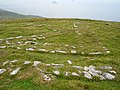 Remains of World War II "EIRE" neutrality sign
 A basking shark feeds in the Dursey Sound.


References
- "E2021: Population of Inhabited Islands Off the Coast 2011 to 2016 by Sex, Islands and Census Year". Census 2016. Central Statistics Office. 2016. Retrieved 13 August 2018.
- "Oileán Baoi/Dursey Island". Logainm.ie.
- "Dursey Island Cable Car Timetable". Retrieved 20 March 2022.
Announcement from Cork County Council [..] The cable car will be closed for a major maintenance programme from 1st April, 2022 - 30th November 2022
- "Temporary ferry confirmed for Dursey Island a day before cable car repair closure". irishtimes.com. Irish Times. 30 March 2022. Retrieved 31 March 2022.
- "Dursey Island - Home". Durseyisland.ie. Retrieved 28 July 2014.
- "West Cork & Kerry website - Dursey Island - 1". www.invectis.co.uk.
- Enright, Damien (26 August 2013). "Cork: Tracing Dursey Island's history". Irish Examiner. Retrieved 28 July 2014.
- "Lighthouses > Bull Rock". CommissionerOfIrishLights.com. Archived from the original on 1 January 2013.
- "Beam Magazine - Volume 36 - The Calf Rock Disaster". commissionersofirishlights.com. Archived from the original on 20 August 2013.
- Penelope Durell (1996). Discover Dursey. Ballinacarriga Books. p. 14.
- Timothy Daniel Sullivan (1908). Bantry, Berehaven and the O'Sullivan Sept. Sealy, Bryers & Walker. p. 20. Retrieved 28 July 2014.
- Samuel Lewis (1837). Topographical Dictionary of Ireland. Retrieved 28 July 2014.
- "The Signal Tower On Dursey Island". Mutantspace. Archived from the original on 4 October 2018.
- Luftwaffe Junkers JU 88 MMW 211 J4-5 (Memorial plaque). Dursey Island cable-car crossing.
- "Dursey Island Loop - Looped Walks". Discoverireland.ie. Retrieved 28 July 2014.
- "Cable Car Timetable". Dursey Island.
- "Cable Car Timetable - Dursey Island". Durseyisland.ie. 14 June 2014. Retrieved 28 July 2014.
- "Dursey Island - Wild Atlantic Way - Signature Point - Discover Ireland". Discoverireland.ie. Retrieved 23 August 2014.
- "Dursey Island Tourism Information". Discoverireland.ie. Retrieved 28 July 2014.
Authority control | |
|---|---|
| General |
|
| National libraries | |
На других языках
[de] Dursey Island
Dursey Island (irisch Baoi Bhéarra oder Oileán Baoi) befindet sich am südwestlichen Ende der Beara-Halbinsel im Westen des County Cork in Irland. Zwischen Dursey und dem Festland liegt der 230 Meter breite Dursey Sound. Er ist zwischen Dursey Point an der Küste und dem Nordwestende der Insel durch Irlands einzige Seilbahn überbrückt.- [en] Dursey Island
[it] Isola di Dursey
Dursey (in gaelico irlandese Oileán Baoi) è una piccola isola, lunga 6,5 km e larga 1,5, situata all'estremità sud-ovest della Penisola di Beara nell'estremo ovest della Contea di Cork, Repubblica d'Irlanda.Другой контент может иметь иную лицензию. Перед использованием материалов сайта WikiSort.org внимательно изучите правила лицензирования конкретных элементов наполнения сайта.
WikiSort.org - проект по пересортировке и дополнению контента Википедии