geo.wikisort.org - River
The Vorderrhein (German; English: Anterior Rhine; Sursilvan: ![]() Rein Anteriur (help·info); Sutsilvan: Ragn Anteriur; Rumantsch Grischun, Vallader, and Puter: Rain Anteriur; Surmiran: Ragn anteriour) is one of the two sources of the Rhine. Its catchment area of 1,512 square kilometres (584 square miles) is located predominantly in the canton of Graubünden (Switzerland). The Vorderrhein is about 76 kilometres (47 mi) long, thus more than 5% longer than the Hinterrhein/Rein Posteriur (each measured to the farthest source). The Vorderrhein, however, has an average water flow of 53.8 m3/s (1,900 cu ft/s), which is less than the flow of the Hinterrhein. According to the Atlas of Switzerland of the Swiss Federal Office of Topography,[1] the source of the Vorderrhein—and thus of the Rhine—is located north of the Rein da Tuma and Lake Toma.
Rein Anteriur (help·info); Sutsilvan: Ragn Anteriur; Rumantsch Grischun, Vallader, and Puter: Rain Anteriur; Surmiran: Ragn anteriour) is one of the two sources of the Rhine. Its catchment area of 1,512 square kilometres (584 square miles) is located predominantly in the canton of Graubünden (Switzerland). The Vorderrhein is about 76 kilometres (47 mi) long, thus more than 5% longer than the Hinterrhein/Rein Posteriur (each measured to the farthest source). The Vorderrhein, however, has an average water flow of 53.8 m3/s (1,900 cu ft/s), which is less than the flow of the Hinterrhein. According to the Atlas of Switzerland of the Swiss Federal Office of Topography,[1] the source of the Vorderrhein—and thus of the Rhine—is located north of the Rein da Tuma and Lake Toma.
| Vorderrhein Anterior Rhine | |
|---|---|
 The Vorderrhein in the Ruinaulta gorge | |
 Area of the Alpine Rhine with its headwaters | |
| Native name | |
| Location | |
| Country | Switzerland |
| Canton | Canton of Graubünden |
| Physical characteristics | |
| Source | |
| • location | Lai Urlaun |
| • coordinates | 46°37′34″N 8°41′04″E |
| Mouth | |
• location | Reichenau |
• coordinates | 46°49′24″N 9°24′28″E |
• elevation | 585 m (1,919 ft) |
| Length | 76 km (47 mi) |
| Basin size | 1,512 km2 (584 sq mi) |
| Discharge | |
| • average | 53.8 m3/s (1,900 cu ft/s) |
| Basin features | |
| Progression | Rhine→ North Sea |
Vorderrhein was also the name of a judicial district that was created in 1851 with the reorganization of the judiciary of Graubünden. In 2001, it was annexed by the District Surselva.
The largest communities along the Vorderrhein are Disentis and Ilanz.
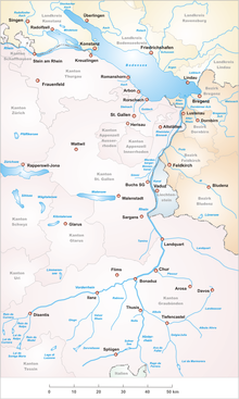
Course
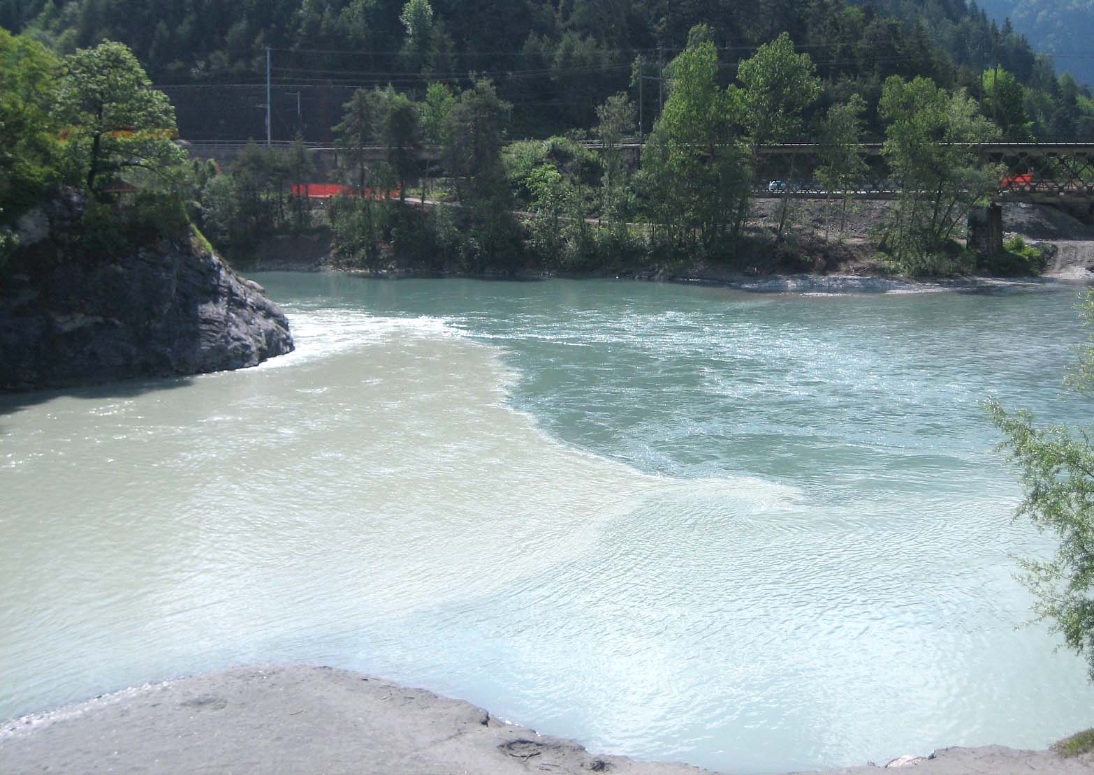
The Vorderrhein flows mostly in an east-northeast direction, through the Surselva, a large longitudinal valley. Its north side is steep, with short valleys, the southern side, however, is divided by some long valleys (similar to the situation in the canton of Valais further west). Consequently, its main tributaries, the Rein da Sumvitg, the Glenner and the Rabiusa all come from the south. In its lower course the Vorderrhein flows through the Flims Rockslide, giving rise to the canyon country of the Ruinaulta. Near Reichenau, it joins the Hinterrhein to form the (Alpine) Rhine.
Headwaters
Some of the tributaries of the Vorderrhein are almost as long as the main branch. In downstream order, they are (measuring their length from their respective sources to the confluence with Hinterrhein at Reichenau):
- Two unnamed streams originating in the Puozas and Milez areas near the Oberalppass
- Rein da Tuma, including the Lai da Tuma and the main head of the lake, about 71 kilometres (44 mi)
- The Aua da Val from the Val valley (70 km)
- Rein da Maighels (75 km) (tributary of the Rein da Curnera)
- Rein da Curnera (about 74 km)
- Rein da Nalps (about 71 km)
- Rein da Medel, the upper reaches in the canton of Ticino are known as Reno di Medel, and also as Froda (about 76 km)
So the longer arms are not the source at Oberalppass, but further southeast. The longest headwater front of the Vorderrhein (and thus the Rhine as a whole, see sources of the Rhine), is the Reno di Medel, which rises on the border of the municipality Quinto in Ticino. In the uppermost part of its course, it runs in the Val Cadlimo, south of the geomorphological main Alpine ridge, west of the Lukmanier Pass.
The culminating point of the Anterior Rhine's drainage basin is the Piz Russein of the Tödi massif of the Glarus Alps at 3,613 metres (11,854 ft) above sea level. It starts with the creek Aua da Russein (lit.: "Water of the Russein").[2]
Tourism

Thanks to its attractive scenery and some interesting passage, the Vorderrhein is a popular river for paddling and rafting, especially the section between Ilanz and Versam.
Along entire length of the Vorderrhein there is a narrow-gauge railway line: from Chur to Disentis there is a line of the Rhätische Bahn. From Disentis, the Furka-Oberalp line of the Matterhorn Gotthard Bahn runs to the Oberalp Pass and on to Andermatt. In the Ruinaulta area, the main road runs to the North of the river, and at its highest point, at Flims, it is about 480 metres (1,575 ft) above the Rhine.
The Senda Sursilvana, a hiking trail along the young Rhine River lead from the Oberalp Pass along the Vorderrhein in the direction of Chur.[3]
Footnotes
- "Trial version of the Atlas of Switzerland with flashing rivers". Archived from the original on 2011-05-04. Retrieved 2011-04-23.
- "1193 - Tödi" (Map). Piz Russein (2016 ed.). 1:25 000. National Map 1:25'000. Wabern, Switzerland: Federal Office of Topography – swisstopo. 2013. ISBN 978-3-302-01193-6. Retrieved 2018-02-28 – via map.geo.admin.ch.
- Hiking Switzerland on the Senda Sursilvana in Graubünden
External links

На других языках
[de] Vorderrhein
Der Vorderrhein (surselvisch Rein Anteriur?/i; sutselvisch Ragn Anteriur; Rumantsch Grischun, Vallader und Puter Rain Anteriur; surmeirisch Ragn anteriour) ist einer der beiden Quellflüsse des Rheins. Sein Einzugsgebiet von 1512 km² liegt überwiegend im Kanton Graubünden (Schweiz). Der Vorderrhein ist mit etwa 77 Kilometern gut 5 Prozent länger als der Hinterrhein (jeweils gemessen über den längsten Quellast). Jedoch ist der Vorderrhein mit einer mittleren Wasserführung von 53,8 m³/s[4] etwas kleiner.- [en] Vorderrhein
[it] Reno Anteriore
Il Reno Anteriore (in tedesco Vorderrhein, in romancio Rein Anteriur) è un fiume svizzero che forma il Reno incontrandosi con il Reno Posteriore poco a valle di Coira, in particolare a Reichenau.[ru] Передний Рейн
Передний Рейн (на сурсильванском диалекте романшского языка Rein Anteriur) — верхний участок реки Рейн. Его водосбор площадью 1512 км² расположен по преимуществу на территории кантона Граубюнден в Швейцарии. Передний Рейн протянулся на 76 км, что на 5 % больше длины Заднего Рейна, при этом расход воды Переднего Рейна (58,3 м³/с)[3] несколько меньше, чем расход воды Заднего Рейна. Исток Переднего Рейна — и самого Рейна — согласно Атласу Швейцарии, выпускаемому Федеральным топографическим ведомством[de] Швейцарии[4], находится севернее реки Рейн-да-Тума[de] на озере Тома.Другой контент может иметь иную лицензию. Перед использованием материалов сайта WikiSort.org внимательно изучите правила лицензирования конкретных элементов наполнения сайта.
WikiSort.org - проект по пересортировке и дополнению контента Википедии