geo.wikisort.org - River
The River Suir (/ʃʊər/ SHOOR; Irish: an tSiúr [ənʲ ˈtʲuːɾˠ] or Abhainn na Siúire [ˌəun̠ʲ n̪ˠə ˈʃuːɾʲə]) is a river in Ireland that flows into the Atlantic Ocean through Waterford after a distance of 185 kilometres (115 mi).[2] The catchment area of the Suir is 3,610 km2.[3] Its long term average flow rate is 76.9 cubic metres per second (m3/s), about twice the flow of either the River Barrow (37.4 m3/s) or the River Nore (42.9 m3/s) before these join, but a little less than the Barrow's flow when it meets the Suir 20 km downstream (over 80 m3/s).[3]
| River Suir | |
|---|---|
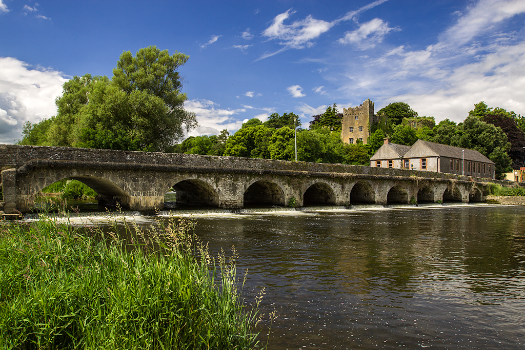
 River Suir at Holycross, Tipperary | |
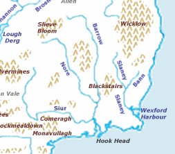 Map of the Three Sisters, including the Suir | |
| Etymology | Old Irish siur, "sister"[1] |
| Native name | Abhainn na Siúire (Irish) |
| Location | |
| Country | Ireland |
| Counties | Tipperary, Waterford, Kilkenny |
| Physical characteristics | |
| Source | Devil's Bit Mountain |
| • location | Templemore, County Tipperary |
| • coordinates | 52.821°N 7.914°W |
| • elevation | 480 m (1,570 ft) |
| Mouth | Waterford Harbour |
• location | Waterford |
• coordinates | 52.11°N 6.56°W |
| Length | 185 km (115 mi) |
| Basin size | 1,394 sq mi (3,610 km2) |
| Discharge | |
| • average | 76.9 m3/s (2,720 cu ft/s) |
Popular with anglers, it holds plentiful reserves of brown trout. While the Suir holds the record for a salmon taken from an Irish river (weighing 57 lb/26 kg, taken on a fly in 1874), as is the case in many other Atlantic rivers, salmon stocks have been in decline in recent years.[4]
Rising on the slopes of Devil's Bit Mountain, just north of Templemore in County Tipperary, the Suir flows south through Loughmore, Thurles, Holycross, Golden and Knockgraffon. Merging with the River Aherlow at Kilmoyler and further on with the Tar, it turns east at the Comeragh Mountains, forming the border between County Waterford and County Tipperary. It then passes through Cahir, Clonmel and Carrick-on-Suir before reaching Waterford. Near the Port of Waterford it meets the River Barrow at Cheekpoint to form a wide navigable estuary, capable of accommodating seagoing vessels up to 32,000 tons dwt. It exits to the sea between Dunmore East and Hook Head.
Together with the Nore and the Barrow, the river is one of the trio known as The Three Sisters.

The Suir is known in Irish as the Siúr and it is thought the present spelling in English with the u and i reversed is due to a mistake. Some people therefore feel that the spelling in English should be Siur and this spelling is occasionally seen.[citation needed] Edmund Spenser (1552–1599) author of The Fairie Queene, in his writings during the Elizabethan age while domiciled in County Cork, referred to the "gentle Shure", probable a most accurate spelling and the most phonetically correct of the period.
In the early years of the 21st century, the remains of a very large Viking settlement were found at a bend in the river at Woodstown just upstream from Waterford.
In Clonmel, the Suir floods the local area after very heavy rainfalls falling in the up river catchment of 2,173 km2. The Office of Public Works (OPW) completed and installed a Flood Forecasting System which was used to forecast flooding in January 2008 and January 2009, the flooding of January 2009 being a 1 in 5-year event. Phase 1 of the Clonmel Flood defence (1–100-year) which stated in 2007 is scheduled for completion in late 2009 and phase two and three as one contract by 2011/2012. The flood defence consists of demountable barriers, walls and earth banks. The Gashouse Bridge, Coleville Road, Davis Road, the quays and the Old Bridge are generally the worst affected areas.
Carrick-on-Suir is tidal and has a 1–50-year flood defence. The Office of Public Works (OPW) now plan to install a 1–200-year flood defence where the river Suir flows through Waterford city.
See also
References
- "eDIL - Irish Language Dictionary". www.dil.ie.
- River Suir, Ireland's Fisheries
- South Eastern River Basin District Management System. Page 38 Archived 3 March 2016 at the Wayback Machine
- Taverner, Eric; John Moore (2006). The Angler's Weekend Book. READ BOOKS. p. 495. ISBN 978-1-4067-9791-6.
External links
- Salmon Ireland, information on the Salmon rivers of Ireland
- The Suir Navigation from Carrick to Clonmel
Authority control | |
|---|---|
| General |
|
| National libraries | |
На других языках
[de] Suir
Die Suir [.mw-parser-output .IPA a{text-decoration:none}ʃuːr] (ir.: An tSiúr oder Abhainn na Siúire, engl. River Suir) ist ein Fluss im Süden Irlands mit einer Gesamtlänge von 183 km.- [en] River Suir
[es] Río Suir
El Suir es un río de Irlanda que desemboca en el océano Atlántico cerca de Waterford tras recorrer 183 kilómetros.[it] Suir
Il fiume Suir (in gaelico An tSiúr or Abhainn na Siúire) è un fiume irlandese che sfocia nel Mare Celtico, vicino a Waterford, dopo avere coperto una distanza di circa 184 km. Il Suir ha un bacino di circa 3526 km quadrati ed è un fiume decisamente apprezzato. dagli appassionati di pesca per l'alto numero di trote che vi vivono. Seppure il più grande salmone mai pescato nei fiumi irlandesi sia stato catturato proprio in questo fiume (pesava circa 26 kg), la pesca di questa specie è in declino già da parecchio tempo. Sorge sulla celebre montagna conosciuta come Devil's Bit, che si trova poco a Nord di Templemore, nella contea di Tipperary e scorre attraverso Loughmore, Thurles, Holycross, Golden e Knockgraffon. Dopo avere ricevuto le acque dell'affluente Tar, gira ad Est presso le Comeragh Mountains, fungendo da confine tra le contee di Kilkenny e Waterford. Arrivato a Waterford si unisce al Barrow e al Nore costituendo un estuario navigabile. Il trio composto dai fiumi precedentemente menzionati prende il nome di "Le tre sorelle".[ru] Шур (река)
Шур (англ. Suir, ирл. An tSiúr) — река в Ирландии. Общая длина — 184 км.Другой контент может иметь иную лицензию. Перед использованием материалов сайта WikiSort.org внимательно изучите правила лицензирования конкретных элементов наполнения сайта.
WikiSort.org - проект по пересортировке и дополнению контента Википедии