geo.wikisort.org - River
The Barrow (Irish: An Bhearú)[1] is a river in Ireland. It is one of The Three Sisters; the other two being the River Suir and the River Nore. The Barrow is the longest of the three rivers, and at 192 km (120 mi), the second-longest river in Ireland, behind the River Shannon. The catchment area of the River Barrow is 3,067 km2 before River Nore joins it a little over 20 km before its mouth.[2] The river's long term average flow rate, again before it is joined by River Nore, is 37.4 cubic metres per second.[2] At the merger with the River Suir, its catchment area is ca. 5,500 km2 and its discharge over 80 m3/s.
| River Barrow | |
|---|---|
 River Barrow at Muine Bheag, County Carlow | |
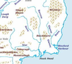 River Barrow and nearby geography | |
| Etymology | Proto-Celtic *boru- ("boil", "bubble") |
| Native name | An Bhearú (Irish) |
| Location | |
| Country | Ireland |
| Counties | Laois, Kildare, Kilkenny, Carlow, Wexford, Waterford |
| Physical characteristics | |
| Source | Slieve Bloom Mountains |
| • location | Glenbarrow, Laois |
| • elevation | 350 m (1,150 ft) |
| Mouth | Celtic Sea |
• location | Waterford Harbour, Waterford |
| Length | 192 km (119 mi) |
| Basin size | 3,067 km2 (1,184 sq mi) (See text) |
| Discharge | |
| • average | 37.4 m3/s (1,320 cu ft/s) (See text) |
| Basin features | |
| River system | Three Sisters |
| Tributaries | |
| • right | River Nore, River Suir |

Course
The source of the River Barrow is at Glenbarrow in the Slieve Bloom Mountains in County Laois.
Among the towns that the River Barrow passes through on its way to the sea beyond Waterford are Portarlington, Monasterevin, Athy, Carlow/Graiguecullen, Bagenalstown, Goresbridge, Graiguenamanagh and New Ross.
The river forms a natural border between, on its right bank, counties Kilkenny and Waterford and, on its left bank, counties Carlow and Wexford.
Name
The Irish hydronym Bhearú has been derived from the Proto-Celtic *boru- ("boil, brew"), which would make it cognate with Borvo, the Celtic god of minerals and spring water.[3] Variant spellings include Berbae (gen. ca. 800/830), Barowe (1522), and Barragh (1641).[1] Ptolemy's Geography (2nd century AD) described a river called Βιργος (Birgu), which could be linked to the Proto-Indo-European *bʰergʰ- "to hide, to protect," referring to Waterford Harbour as a place of refuge.[4][5]
The river's name is associated to the legendary deeds of Dian Cecht, who slew three serpents found in the heart of The Morrígan's infant son and threw them into the Barrow, thus causing it to boil.[6]
- Sloighedh la Domhnall ua Néill co Laighnibh co ros-indir o Bherbha siar go fairrge, & do-bert bóromha mhór lais, & do-rad forbhais for Ghallaibh, & for Laighnibh co cenn da mhíos. As don chur-sin torchair Fionn, mac Goirmghiolla, Dunghal mac Dúnghaile I Riagáin, & Ronán, mac Bruadair, mic Duibhgiolla, & aroile saor-chlanna do Laighnibh amaille friu.[7]
Translation:
- An army was led by Domnall ua Néill into Leinster; and he plundered from the Berbha eastwards to the sea; and he carried off a great prey of cattle; and he laid siege to the Norsemen and the Leinstermen for two months. On this occasion were slain Fionn, son of Goirmghilla; Dunghal, son of Dunghal Ua Riagain; Ronan, son of Bruadar, son of Duibhghilla, and other nobles of the Leinstermen along with them.
History
The Barrow historically provided a natural boundary between the kingdoms of Laigin on the eastern shore and Osraige on the western shore.
There was a proverb quoted by Sir John Davies that “whoso lives by west of the Barrow, lives west of the law.”[8]
Barrow navigation
The River Barrow forms a major part of Ireland's inland waterways network, providing an inland link between the port of Waterford and the Grand Canal, which in turn connects Dublin to the River Shannon. There are three sections to the navigation:
- The tidal River Barrow, which together with the tidal reaches of its tributaries, the River Suir and River Nore, constitute 88 km (55 miles) of tidal river navigation.
- The non-tidal river navigation featuring 23 locks, continuing 66 km (41 miles) inland from the tidal limit of the Barrow at St Mullin's to Athy.
- The Barrow Line of the Grand Canal connects to the river at Athy and continues northwards a further 45 km (28 miles) with 9 locks, connecting to the mainline of the Grand Canal at Lowtown, and so to Dublin.
Recreation
Parts of the Barrow attract kayakers and swimmers, primarily in the summer months.[9] The Barrow Way is a 120 kilometre long distance walk along the Barrow, one of Ireland's National Waymarked Trails. The trail follows the Barrow Line, and then along the towpaths along the non-tidal part of the river, ending in St. Mullins.
See also
- Rivers of Ireland
- List of rivers in Ireland
- The Three Sisters
References
- "An Bhearú/River Barrow". logainm.ie. Irish Placenames Database. Archived from the original on 24 September 2021. Retrieved 9 December 2020.
- South Eastern River Basin District Management System. Page 38 Archived 2016-03-03 at the Wayback Machine
- Monnier, Nolwena (2019). "Nommer la nature : toponymie de la nature dans la Topographia Hibernica de Gerald of Wales". Études irlandaises (44–1): 31–46. doi:10.4000/etudesirlandaises.6884. ISSN 0183-973X.
- "Ireland" (PDF). www.romaneranames.uk. Archived (PDF) from the original on 2 April 2019. Retrieved 4 May 2019.
- Freeman, Philip (28 June 2010). War, Women, and Druids: Eyewitness Reports and Early Accounts of the Ancient Celts. University of Texas Press. ISBN 9780292789135. Archived from the original on 24 September 2021. Retrieved 3 October 2020 – via Google Books.
- Shaw, John. "Indo-European Dragon-Slayers and Healers, and the Irish Account of Dian Cécht and Méiche". Archived from the original on 24 September 2021. Retrieved 17 May 2016.
{{cite journal}}: Cite journal requires|journal=(help) - "Annals of the Four Masters". www.ucc.ie. Archived from the original on 21 January 2016. Retrieved 11 December 2014.
- Falkiner, Caesar Litton (1904). Illustrations of Irish history and topography, mainly of the seventeenth century. London: Longmans, Green, & Co. p. 117. ISBN 1-144-76601-X.
- Ball, Jamie (8 July 2018). "Going with the flow on the River Barrow: Could this really be just 1.5 hours from Dublin?". Independent.ie. Archived from the original on 1 October 2020. Retrieved 31 January 2020.
External links
Places in County Kildare | ||
|---|---|---|
County town: Naas | ||
| Towns |  | |
| Villages and Townlands |
| |
| Landforms | ||
| Topics |
| |
Authority control | |
|---|---|
| General |
|
| National libraries | |
На других языках
[de] River Barrow
Der River Barrow (irisch: Abhainn na Bearú oder An Bhearú) ist – nach dem Shannon – mit 192 km der zweitlängste Fluss in Irland. Er entspringt in den Slieve Bloom Mountains im County Laois[1] und durchfließt mehrere Countys in der Republik Irland.- [en] River Barrow
[es] Río Barrow
El Barrow es un río de Irlanda, es uno de los ríos a los que se llama "las tres hermanas" (The Three Sisters) - en inglés un río se considera de género femenino -, siendo las otras dos "hermanas" el río Suir y el río Nore. El Barrow es el más largo e importante de los tres, y el segundo más largo de Irlanda, tras el río Shannon.[it] Barrow (fiume)
Il Barrow (An Bhearú in irlandese) è un fiume irlandese, uno dei tre che fa parte delle tre Sorelle; gli altri due sono il Nore e il Suir. Dei tre il Barrow è sia il più lungo, sia quello dotato della maggiore portata. Grazie ai suoi 192 km è il secondo fiume irlandese per lunghezza dopo lo Shannon.[ru] Барроу (река)
Ба́рроу (англ. Barrow, ирл. Abhainn na Bearú, An Bhearú [Ан-Вяру], др.‑ирл. Berba) — река в Ирландии. Общая длина — 191 км (2-е место в стране).Другой контент может иметь иную лицензию. Перед использованием материалов сайта WikiSort.org внимательно изучите правила лицензирования конкретных элементов наполнения сайта.
WikiSort.org - проект по пересортировке и дополнению контента Википедии