geo.wikisort.org - River
The River Slaney (Irish: An tSláine or Irish: Abhainn na Sláine, meaning 'river of health') is a large river in the southeast of Ireland. It rises on Lugnaquilla Mountain in the western Wicklow Mountains and flows west and then south through counties Wicklow, Carlow and Wexford for 117.5 km (73 mi),[1] before entering St George's Channel in the Irish Sea at Wexford town. The estuary of the Slaney is wide and shallow and is known as Wexford Harbour. The catchment area of the River Slaney is 1,762 km2.[2] The long term average flow rate of the River Slaney is 37.4m3/s[3]
| River Slaney | |
|---|---|
 River Slaney at Stratford-on-Slaney | |
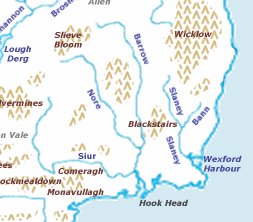 Map of the rivers of southeast Ireland | |
| Native name |
|
| Location | |
| Country | Ireland |
| Physical characteristics | |
| Source | |
| • location | Lugnaquilla, County Wicklow |
| • elevation | 549 metres (1,801 ft) |
| Mouth | Irish Sea |
• location | Wexford Harbour, County Wexford |
| Length | 117.5 kilometres (73.0 mi) |
| Basin size | 1,762 square kilometres (680 sq mi) |
| Discharge | |
| • average | 37 m3/s (1,300 cu ft/s) |
| Basin features | |
| Tributaries | |
| • left | River Derreen, River Derry, River Bann, River Ballyedmond, River Sow |
| • right | Browns Beck Brook, River Clody, River Urrin, River Boro |
Towns that the Slaney runs through include Stratford-on-Slaney, Baltinglass, Tullow, Bunclody, Enniscorthy and Wexford. The river is crossed by 32 road bridges and one railway bridge.[4]
Wildlife
Varied and plentiful wildlife can be found in the environs of the river. In Wicklow, herds of deer can be seen, as well as swans, dippers, wild ducks, herons and kingfishers. At dusk, bats, owls and otters may be seen, while the mudflats of the estuary are favoured by black-headed gulls, redshanks and oystercatchers.[5] The rare goosander can be seen on the Slaney at Kildavin. In season, salmon and trout and pike are fished.[6]
History
Ptolemy's Geography (2nd century AD) described a river called Μοδοννος (Modonnos, "mudflats") which may have referred to the River Slaney, though scholarly opinion remains divided on the issue.[7]
There is a reference to the Slaney in the Irish ballad Boolavogue,[8] commemorating the Battle of Vinegar Hill in the Irish Rebellion of 1798.
Tributaries
Tributaries of the Slaney include the River Derreen, the River Derry, the River Clody, the River Bann, the River Urrin, the River Boro, and the River Sow.
References
- Ordnance Survey of Ireland: Rivers and their Catchment Basins 1958 (Table of Reference)
- South Eastern River Basin District Management System. Page 38 Archived 2016-03-03 at the Wayback Machine
- South Eastern River Basin District Management System. Page 38 Archived 2016-03-03 at the Wayback Machine
- Duffy, John. River Slaney, from source to sea, 2006, ISBN 978-0-9554184-0-2, p.30
- Duffy, p.19
- Slaney River Trust Archived 2008-01-02 at the Wayback Machine
- "Ireland" (PDF). www.romaneranames.uk. p. 3. Retrieved 1 June 2021.
- McCall, PJ 1898, (High Kings version). "Boolavogue Lyrics". bellsirishlyrics.com. Retrieved 7 June 2021.
External links
- River Slaney at the Encyclopædia Britannica
- River Slaney: Environment Under Threat
Authority control | |
|---|---|
| General |
|
| National libraries | |
На других языках
[de] Slaney
Die Slaney oder River Slaney (irisch: An tSláine oder Abhainn na Sláine, benannt nach Sláinghe, einem myth. König der Fir Bolg) ist ein Fluss im Südosten der Republik Irland.[1]- [en] River Slaney
[es] Río Slaney
El Slaney (irlandés, Abhainn na Sláine, "río de la salud") es un río en el sureste de Irlanda. Surge en la montaña de Lugnaquilla en la parte occidental de los montes Wicklow y fluye hacia el oeste y luego al sur a través de los condados de Wicklow, Carlow y Wexford, antes de entrar en el Canal de San Jorge en el mar de Irlanda en la ciudad de Wexford. El estuario del Slaney es ancho y poco profundo y es conocido como Wexford Harbour.[it] Slaney
Lo Slaney è un fiume dell'Irlanda sud-orientale. Nasce nelle Wicklow Mountains e scorre a sud e poi ad est nelle contee di Wicklow, Carlow e di Wexford, prima di gettarsi nel Canale di San Giorgio, che si trova nel mare d'Irlanda.[ru] Слейни
Слейни[1][2] (ирл. An tSláine)[3] — река в Ирландии.Находится на юго-востоке страны. Река берёт начало на высоте 926 м над уровнем моря на горе Лугнакилла (англ. Lugnaquilla) в графстве Уиклоу. Ниже протекает через графства Карлоу и Уэксфорд. Впадает в Ирландское море в гавани Уэксфорд[en]. Длина реки около 118 км. Среди крупных притоков — Дерри, Клоди и Банн[en][4]. Площадь водосборного бассейна составляет 1762 км², из которых 57 % занято пастбищами[5]. В реке ведётся лов атлантического лосося и кумжи[6]. На реке построено 32 автомобильных моста и один железнодорожный[7].Другой контент может иметь иную лицензию. Перед использованием материалов сайта WikiSort.org внимательно изучите правила лицензирования конкретных элементов наполнения сайта.
WikiSort.org - проект по пересортировке и дополнению контента Википедии