geo.wikisort.org - River
The Lockyer Creek is a creek located in South East Queensland, Australia. A tributary of the Brisbane River, the creek is a major drainage system in the Lockyer Valley. Rising on the eastern slopes of the Great Dividing Range, the creek flows generally north-easterly for more than 100 kilometres (62 mi) before it reaches its confluence with the Brisbane River north-northeast of Lowood, and downstream from the Wivenhoe Dam. The creek is named after Edmund Lockyer.[2]
| Lockyer | |
|---|---|
 Lower Lockyer Creek, 2011 | |
 Location of the Lockyer Creek mouth in Queensland | |
| Etymology | Edmund Lockyer |
| Location | |
| Country | Australia |
| State | Queensland |
| Region | South East Queensland |
| Cities | Helidon, Grantham, Gatton |
| Physical characteristics | |
| Source | Great Dividing Range |
| • location | Main Range National Park |
| • coordinates | 27°28′6″S 152°5′19″E |
| • elevation | 216 m (709 ft) |
| Mouth | confluence with the Brisbane River |
• location | near Wivenhoe Pocket |
• coordinates | 27°24′59″S 152°36′20″E |
• elevation | 37 m (121 ft) |
| Length | 113 km (70 mi) |
| Basin size | 3,032 km2 (1,171 sq mi) |
| Basin features | |
| River system | Brisbane River |
| Tributaries | |
| • left | Buaraba Creek, Redbank Creek (Queensland), Sheep Creek (Queensland), Alice Creek (Queensland), Murphy's Creek |
| • right | Plain Creek, Laidley Creek, Sandy Creek (Queensland), Tenthill Creek, Ma Ma Creek, Flagstone Creek (Queensland), Gatton Creek |
| National park | Main Range National Park |
| [1] | |
Course and features

Draining parts of the western Scenic Rim, the creek's headwaters are in the Main Range National Park, a small sub-section of the Great Dividing Range. Its tributaries drain the slopes east of Toowoomba and areas to the north of Gatton. The total stream length of the Lockyer Creek network is 6,056 kilometres (3,763 mi).[3]
The total catchment area is 3,032 km2 (1,171 sq mi),[4] and covers nearly one quarter of the total catchment area of the Brisbane River.[2] O'Reillys Weir is located about 1 kilometre (0.62 mi) upstream from the creek's confluence with the Brisbane River. Approximately 5 kilometres (3.1 mi) upstream from the junction of Lockyer Creek and the Brisbane River is the Wivenhoe Dam. Tributaries flowing into Lockyer Creek include Flagstone Creek, Sandy Creek, Alice Creek, Laidley Creek, Tenthill Creek, Murphys Creek and Ma Ma Creek.[4]
Lower areas of the catchment have been cleared for intensive agriculture.[3] Upper parts of the catchment remain mostly forested,[3] partially protected within Lockyer National Park formerly known as White Mountain State Forest. Bushfires, soil protection, water quality and flood management are the main resource management issues for the waterway.[5] The creek is significantly degraded. The poor conditions have resulted in unstable stream banks and gully erosion from the removal of riparian vegetation.[3][6]

There are a total of nine major private and public water storages within this drainage system, including Atkinson Dam, Bill Gunn Dam and Lake Clarendon.[4] The Lockyer Creek valley had been one of the driest catchments in Queensland during the recent droughts in Australia.
Flood events
During the 2011 Queensland floods, on 10 and 11 January the creek experienced severe flash flooding from overnight and daytime heavy rain in a catchment of about 2,000 square kilometres (770 sq mi).[7] During the floods the creek reached 18 metres (59 ft) deep,[8] a record that was higher than what was experienced during the 1974 Brisbane flood.[8]
The Bureau of Meteorology recorded a rise of 8 metres (26 ft) in 23 minutes during the flash flood but initially dismissed the reading as a fault.[9] It was estimated that 4,000 tonnes or 4,000 megalitres (1,100×106 US gal) of water per second flowed through Lockyer Creek, leading to the use of descriptive phrases such as "wall of water", or even "inland tsunami".[9] Water rose approximately 9 feet (2.7 m) above the 1893 flood level recorded at the Lockyer Creek Railway bridge (see below).
A report by GHD Group for the Brisbane City Council suggested that flood mitigating dams on Lockyer Creek and Bremer River could be a useful measure for flood proofing Brisbane.[10]
Bridges
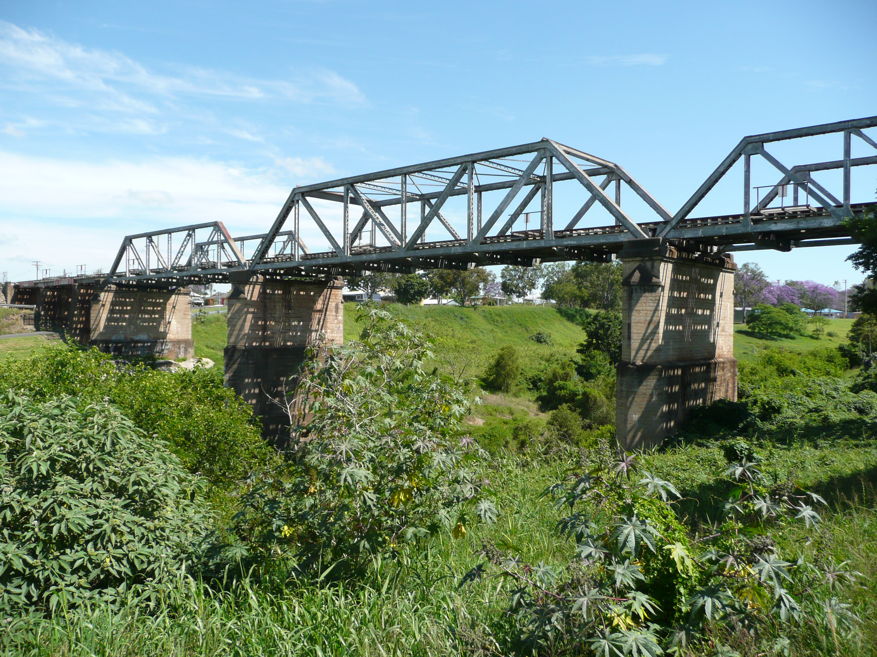
The Lockyer Creek Bridge at Bageli Park, designed by William Pagan, is one of the largest of its type in Queensland and one of Australia's first reinforced concrete arch rail bridges.[11] The bridge, built in 1910/1911, features three spans, each supported by two arches, and appeared on a stamp that was part of a series featuring landmark bridges.[12] A model of the bridge was featured in the April 2011 edition of the Australian Model Railway Magazine.[13] The bridge is still used for very heavy Brisbane bound coal and grain traffic. Another single arch bridge on the same line, but over a side gully, with the same name, is closer to Gatton and was built in 1903.[14] Further downstream in the district of Clarendon, an earlier railway structure (1885) built of timber piles with a deck of iron trusses, is possibly as spectacular. This bridge is no longer used by rail traffic.[15]
Heritage listings
Lockyer Creek has a number of heritage-listed sites, including:
- Toowoomba – Helidon Line: Lockyer Creek Railway Bridge (Lockyer)[16]
- Toowoomba – Helidon Line: Lockyer Creek Railway Bridge (Murphys Creek)[11]
- Brisbane Valley railway line: Lockyer Creek Railway Bridge (Clarendon)[17]
See also
- List of rivers of Queensland
References
- "Map of Lockyer Creek, QLD". Bonzle Digital Atlas of Australia. Retrieved 24 September 2015.
- "Lockyer Creek". (Department of Environment and Resource Management. 28 September 2009. Archived from the original on 8 January 2010. Retrieved 19 May 2011.
- "Lockyer Creek Catchment". Ecosystem Health Monitoring Program. Healthy Waterways. 2010. Retrieved 19 May 2011.
- "Surface Water Management Area: Lockyer River". Australian Natural Resources Atlas. Commonwealth of Australia. 16 November 2007. Archived from the original on 29 July 2008. Retrieved 28 April 2008.
- South East Queensland Regional Strategy Group, Strategic Guide to Resource Management in South East Queensland, November 2000. p 102.
- "Lockyer Catchment" (PDF). Healthy Waterways. 2014. Retrieved 24 September 2015.
- "Lockyer Valley flash floods death toll now at 13, after five more bodies found, dozens still missing". The Courier Mail. Queensland Newspapers. 11 January 2011. Retrieved 11 January 2011.
- Koch, Tony (12 January 2011). "Lockyer Creek became a raging torrent". The Australian. News Limited. Retrieved 19 May 2011.
- Marriner, Cosima (1 May 2011). "The day a deadly torrent struck without warning". Sydney Morning Herald. Fairfax Media. Retrieved 19 May 2011.
- Vogler, Sarah (3 May 2011). "Dams mooted for Bremer River, Lockyer Creek". The Courier-Mail. News Queensland. Retrieved 19 May 2011.
- "Lockyer Creek Railway Bridge (Guinn Park) (entry 600515)". Queensland Heritage Register. Queensland Heritage Council. Retrieved 13 January 2011.
- "Australia Post Stamps: Landmark Bridges". Australia Post. Archived from the original on 11 September 2007. Retrieved 27 January 2008.
- "Lockyer Creek Bridge 1". Qldrail.net. 19 January 2011. Retrieved 26 March 2011.
- Queensland Environmental Protection Agency, Heritage Trails of the Great South East, State of Queensland, 2000 p.60. ISBN 0-7345-1008-X
- "Community Directory – Lowood District Community Website". Lowood District Community. Archived from the original on 20 August 2011. Retrieved 26 March 2011.
- "Lockyer Creek Railway Bridge (Lockyer) (entry 600513)". Queensland Heritage Register. Queensland Heritage Council. Retrieved 10 July 2013.
- "Lockyer Creek Railway Bridge (Clarendon) (entry 600495)". Queensland Heritage Register. Queensland Heritage Council. Retrieved 1 August 2014.
External links
- Lockyer Creek catchment map (PDF) (Map). Healthy Waterways. August 2005.
Rivers of Queensland | |||||||||||||||
|---|---|---|---|---|---|---|---|---|---|---|---|---|---|---|---|
| |||||||||||||||
| |||||||||||||||
| |||||||||||||||
| |||||||||||||||
| |||||||||||||||
| |||||||||||||||
На других языках
[de] Lockyer Creek
Der Lockyer Creek ist ein Fluss im Lockyer Valley in South East Queensland in Australien.- [en] Lockyer Creek
Другой контент может иметь иную лицензию. Перед использованием материалов сайта WikiSort.org внимательно изучите правила лицензирования конкретных элементов наполнения сайта.
WikiSort.org - проект по пересортировке и дополнению контента Википедии