geo.wikisort.org - River
This is a list of named rivers that flow either wholly or partially within the boundaries of the four ceremonial counties that form Yorkshire. There are twenty five rivers of at least 20 kilometres (12 mi) in total. The majority of these waterways lie wholly within the county boundaries, except for; the Ribble, which flows into the Irish Sea at Lytham; the Rother, whose source is located in Derbyshire Peak District; the Greta, which flows into Lancashire to join the River Lune; and the Tees, which flows partly within County Durham and forms some of the boundary with North Yorkshire.

The direction of stream flow in Yorkshire is influenced by the three major drainage divides. The Pennines in the west and south, the North York Moors in the north-east and the Yorkshire Wolds, the coastal range of hills on the east. This represents a large drainage area that mostly flows into the Vale of York and into the North Sea via the River Humber. Though named a river, the Humber is considered to be an estuary.
The Humber river system is tidal as far inland as Naburn Lock on the River Ouse,[1] Knottingley on the River Aire[2][3] and Askern on the River Don.[4] The River Humber has the second largest tidal range in the UK at 7.2 metres (24 ft). The largest is the Bristol Channel at nearly double that range.[5]
Source data for the table below came from the National Environment Research Council Centre for Ecology and Hydrology, Ordnance Survey, Environment Agency and Google Earth. In the table, total lengths are given in miles (mi) and kilometres (km), and elevations are in feet (ft) and metres (m). River lengths are taken from actual source when wholly within the Yorkshire County boundary, else measured from where the river enters or leaves the county.
Images
 The River Esk at Whitby
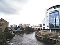 The River Aire and the Leeds-Liverpool canal in Leeds
 River Sheaf joins River Don at Sheffield
 Tidal Barrier on the River Hull at Kingston upon Hull
 Infinity Bridge on River Tees in the Borough of Stockton-On-Tees
 The road bridge at Stamford Bridge over the River Derwent
 River Wharfe at Tadcaster
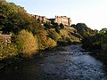 Richmond Castle and the River Swale
 River Ure at Boroughbridge
 River Nidd and railway viaduct at Knaresborough


List
The use of the term source in this list is taken to mean the point at which the name of the river is first used on Ordnance Survey maps.
| Key |
|---|
| Name | Total length | Mouth | Mouth coordinates |
Mouth elevation | Source | Source coordinates |
Source elevation | Catchment Area |
|---|---|---|---|---|---|---|---|---|
| Aire | 114 km 71 miles |
River Ouse, Yorkshire near Airmyn | 53°43′35″N 0°54′22″W | 3 m 9.8 ft |
Malham Tarn | 54°5′45″N 2°10′0″W | 377 m 1,237 ft |
856 km² 331 sq miles[6] |
| Arkle Beck | 17 km approx | River Swale at Reeth | NY 987 030 | 177 m | Arkengarthdale Moor | NY 989 088 | 477 m | |
| Ashfold Side Beck | 9 km Approx | River Nidd near Pateley Bridge | SE 152 664 | 117 m | Ashfold Gill Head | SE 073 685 | 504 m | |
| Bain | 3.95 km 2.45 miles |
River Ure near Bainbridge | 54°18′45″N 2°6′3″W | 210 m 690 ft |
Semer Water | 54°17′3″N 2°7′22″W | 252 m 827 ft |
Not available |
| Barney Beck | 6 km approx | River Swale at Healaugh | SE 015 984 | 186 m | Reeth High Moor | NY 963 012 | 451m | Not available |
| Birkdale Beck | 6 km approx | River Swale near Keld | NY 872 013 | 341 m | Beck Meetings | NY 820 035 | 455 m | Not available |
| Bishopdale Beck | 11 km approx | River Ure near Aysgarth | SE 019 879 | 144 m | Dale Head | SD 961 826 | 218 m | Not available |
| River Burn | 13 km approx | River Ure at Masham | SE 230 797 | 70 m | Masham Moor | SE 113 799 | 292 m | |
| Calder | 71 km 44 miles |
River Aire | 53°43′54″N 1°21′33″W | 14 m 46 ft |
Heald Moor, near Todmorden | 53°44′23″N 2°9′53″W | 220 m 720 ft |
930 km² 360 sq miles[7] |
| Colne | 20.6 km 12.8 miles |
River Calder near Bradley | 53°40′49″N 1°43′52″W | 52 m 171 ft |
Confluence of Redbrook Clough and Haigh Clough | 53°36′19″N 1°57′28″W | 234 m 768 ft |
245 km² 95 sq miles[8] |
| Cover | 22 km 14 miles |
River Ure near Middleham | 54°16′43″N 1°46′25″W | 98 m 322 ft |
Great Hunters Sleets near Woodale | 54°11′2″N 2°1′29″W | 487 m 1,598 ft |
Not available |
| Crimple | 25 km | River Nidd near Wetherby | SE 405 531 | 21 m | Crimple Head Farm | SE 247 519 | 221 m | |
| Dearne | 51.9 km 32.2 miles[9] |
River Don near Conisbrough | 53°29′39″N 1°14′34″W | 17 m 56 ft |
Birdsedge near Denby Dale | 53°33′52″N 1°42′37″W | 319 m 1,047 ft |
310.8 km² 120 sq miles[10] |
| Derwent | 115.1 km 71.5 miles |
River Ouse at Barmby on the Marsh | 53°44′58″N 0°58′8″W | 10 m 33 ft |
Derwent Head near RAF Fylingdales | 54°22′50″N 0°37′24″W | 260 m 850 ft |
1,634 km² 631 sq miles[11] |
| Dibb | 5.2 km 3.2 miles |
River Wharfe near Appletreewick | 54°2′27″N 1°56′35″W | 143 m 469 ft |
Grimwith Reservoir | 54°4′48″N 1°54′41″W | 253 m 830 ft |
25.5 km² 9.8 sq miles[12] |
| Doe | 5.92 km 3.68 miles |
Confluence with River Twiss at Ingleton | 54°9′12″N 2°28′15″W | 118 m 387 ft |
God's Bridge near Chapel-Le-Dale | 54°10′58″N 2°24′40″W | 234 m 768 ft |
Not available |
| Don | 114.1 km 70.9 miles[9] |
River Ouse at Goole | 53°41′47″N 0°51′59″W | 3 m 9.8 ft |
Confluence of Great Grains Clough and Black Grough near Winscar Reservoir, Dunford Bridge | 53°31′14″N 1°48′16″W | 416 m 1,365 ft |
1,256.2 km² 485 sq miles[13] |
| Dove, Nth Yorks | 30.22 km 18.78 miiles |
River Rye near Salton | 54°12′6″N 0°54′35″W | 24 m 79 ft |
Farndale Moor, Nth Yorkshire | 54°24′24″N 1°2′23″W | 372 m 1,220 ft |
59.2 km² 22.9 sq miles [14] |
| Dove, Sth Yorks | 7.91 km 4.92 miles |
River Dearne near Darfield, South Yorkshire | 53°31′43″N 1°22′9″W | 22 m 72 ft |
Worsbrough Reservoir | 53°31′34″N 1°28′27″W | 56 m 184 ft |
Not available |
| Earby Beck | River Aire near Skipton | SD 961 514 | m | Foulridge | SD 889 427 | m | Not available | |
| Eastburn Beck | Kellythorpe | TA 023 564 | 14 m | Kirkburn | SE 984 552 | 22 m | Not available | |
| Eller Beck | Beck Hole | NZ 820 021 | 59 m | Allerston High Moor | SE 871 958 | 253 m | Not available | |
| Eshton Beck | Gargrave | SD943539 | 102 m | Winterburn | SD 933 585 | 149 m | Not available | |
| Esk | 45 km 28 miles |
North Sea at Whitby | 54°29′33″N 0°36′44″W | 0 m 0 ft |
The Esklets near Westerdale | 54°24′3″N 0°59′8″W | 251 m 823 ft |
308 km² 119 sq miles[15] |
| Ewden Beck | River Don at Wharncliffe Side | SK 298 954 | 106 m | Margery Hill | SK 188 958 | 541 m | Not available | |
| Foss | 31 km 19 miles |
River Ouse, York | 53°57′5″N 1°4′42″W | 12 m 39 ft |
Near Oulston Reservoir, Yearsley | 54°9′38″N 1°7′54″W | 160 m 520 ft |
118 km² 46 sq miles[16] |
| Foulness | 25.51 km 15.85 mi |
Market Weighton Canal | 53°46′56″N 0°42′57″W |
1 m 3 ft |
Shiptonthorpe | 53°53′8″N 0°42′39″W |
20 m 66 ft |
N/A |
| Greta | 7.55 km 4.69 miles |
Leaves Yorkshire near Burton-in-Lonsdale | 54°8′35″N 2°33′30″W | 64 m 210 ft |
Confluence of River Doe and River Twiss at Ingleton | 54°9′12″N 2°28′15″W | 118 m 387 ft |
86.1 km² 33.2 sq miles[17] |
| Hedon Haven/Burstwick Drain | 12 kilometres (7.5 mi) | Paull | 53.7275°N 0.2363°W | 0 metres (0 ft) | Elstronwick | 53.7596°N 0.1310°W | 5 metres (16 ft) | 26 square kilometres (10 sq mi) |
| Hertford | 16 km approx | River Derwent at Binnington Carr | SE 970 789 | 23 m | Hunmanby | TA 110 771 | 49 m | |
| Holme | 13.86 km 8.61 miles |
River Colne at Huddersfield | 53°38′20″N 1°47′4″W | 72 m 236 ft |
Holmbridge | 53°13′15″N 1°49′27″W | 188 m 617 ft |
97.4 km² 37.6 sq miles[18] |
| How Stean Beck | 6 km Approx | River Nidd at Lofthouse | SE 102730 | 157 m | SE 055 728 | 338 m | ||
| Hull | 46.84 km 29.11 miles |
River Humber at Kingston upon Hull | 53°44′17″N 0°19′55″W | 0 m 0 ft |
Confluence of Driffield Trout Stream and Little Driffield Beck | 53°59′39″N 0°26′25″W | 17 m 56 ft |
378.1 km² 146 sq miles[19] |
| Humber | 61.9 km 38.5 miles |
North Sea at Spurn Head | 53°32′33″N 0°6′23″E | 0 m 0 ft |
Trent Falls | 53°42′8″N 0°41′46″W | 0 m 0 ft |
Not available without Trent Basin |
| Kyle | 9.31 km 5.78 miles |
River Ouse near Newton-on-Ouse | 54°2′5″N 1°13′28″W | 11 m 36 ft |
Confluence of Derrings Beck and Carle Beck near Tholthorpe | 54°5′24″N 1°15′38″W | 12 m 39 ft |
Not available |
| Laver | 15 km 9.3 miles |
River Skell near Ripon | 54°7′55″N 1°32′8″W | 33 m 108 ft |
Confluence of North Gill Beck and South Gill Beck at Dallowgill | 54°8′22″N 1°42′30″W | 170 m 560 ft |
Not available |
| Leven | 46.2 km 28.7 miles |
River Tees near Yarm | 54°30′31″N 1°20′12″W | 16 m 52 ft |
Kildale Moor, Nth Yorks | 54°27′50″N 1°2′47″W | 279 m 915 ft |
196.3 km² 75.8 sq miles[20] |
| Little Don River | 14 km approx | River Don near Stocksbridge | SK 290 979 | 132 m | Harden Moor | SK 169 993 | 348 m | |
| Loxley | 16 km 9.9 miles |
River Don, South Yorkshire at Owlerton | 53.400526°N 1.486888°W | 58 m 190 ft |
Damflask Reservoir near Stacey Bank | 53°24′38″N 1°34′16″W | 133 m 436 ft |
43.5 km² 27 sq miles[21] |
| Nidd | 95.45 km 59.31 miles |
River Ouse, Yorkshire at Nun Monkton | 54°0′51″N 1°13′8″W | 13 m 43 ft |
Nidd Heads on Great Whernside | 54°10′20″N 2°0′11″W | 660 m 2,170 ft |
516 km² 199 sq miles[22] |
| Ouse | 84 km 52 miles |
Trent Falls | 53°42′8″N 0°41′46″W | 0 m 0 ft |
River Ure at Cuddy Shaw Reach | 54°2′4″N 1°16′30″W | 12 m 39 ft |
3,315 km² 1,280 sq miles[23] |
| Ribble | 38.48 km 23.91 miles |
County Border near Swinden | 53°58′16″N 2°13′55″W | 117 m 384 ft |
Ribble Head | 54°12′42″N 2°21′43″W | 290 m 950 ft |
204 km² 79 sq miles[24] |
| Riccall | 18.36 km 11.41 miles |
River Rye | 54°12′14″N 0°54′58″W | 24 m 79 ft |
Confluence of Bonfield Gill and Bogmire Gill near Helmsley | 54°17′52″N 1°3′40″W | 130 m 430 ft |
57.6 km² 22.2 sq miles[25] |
| Rivelin | 6.81 km 4.23 miles |
River Loxley | 53°23′59″N 1°30′41″W | 77 m 253 ft |
Rivelin Dams near Sheffield | 53°22′43″N 1°35′11″W | 206 m 676 ft |
Not available |
| Rother | 16.77 km 10.42 miles |
River Don at Rotherham | 53°21′31″N 1°21′43″W | 26 m 85 ft |
County Boundary at Eckington | 53°18′56″N 1°20′25″W | 47 m 154 ft |
352.2 km² 136 sq miles[26] |
| Ryburn | 11.4 km 7.1 miles |
River Calder at Sowerby Bridge | 53°42′28″N 1°54′42″W | 80 m 260 ft |
Confluence of unnamed stream and Black Castle Clough near Rishworth | 53°39′35″N 2°1′29″W | 361 m 1,184 ft |
13 sq miles[27] |
| Rye | 61.5 km 38.2 miles |
River Derwent near Malton | 54°10′15″N 0°44′25″W | 19 m 62 ft |
Rye Head near Osmotherley | 54°22′23″N 1°14′12″W | 302 m 991 ft |
679 km² 262 sq miles[28] |
| Ryton | 3.4 km 2.1 miles |
County Border with Nottinghamshire | 53°19′22″N 1°10′19″W | 48 m 157 ft |
Confluence of Anston Brook and Pudding Dike | 53°20′5″N 1°11′26″W | 71 m 233 ft |
77 km² 30 sq miles[29] |
| Seven | 34.9 km 21.7 miles |
River Rye | 54°11′13″N 0°51′51″W | 22 m 72 ft |
Danby High Moor near Rosedale Abbey | 54°24′2″N 0°57′7″W | 330 m 1,080 ft |
121.6 km² 47 sq miles[30] |
| Sheaf | 9.6 km 6 miles |
River Don | 53°23′7″N 1°27′44″W | 53 m 174 ft |
Confluence of Oldhay Brook and Totley Brook | 53°19′12″N 1°31′24″W | 143 m 469 ft |
49.1 km² 19 sq miles[31] |
| Skell | 19 km 12 miles |
River Ure near Ripon | 54°8′0″N 1°30′3″W | 23 m 75 ft |
Howson Ridge near Wath-in-Nidderdale | 54°7′2″N 1°44′59″W | 350 m 1150 ft |
Not available |
| Skirfare | 15.24 km 9.47 miles |
River Wharfe | 54°7′8″N 2°2′8″W | 197 m 646 ft |
Confluence of Foxup Beck and Cosh Beck | 54°11′12″N 2°11′49″W | 313 m 1,027 ft |
Not available |
| Spen | 8 km 5 miles |
River Calder at Dewsbury | 53°40′49″N 1°39′4″W | 42 m 138 ft |
Confluence of Hunsworth Beck and Nann Hall Beck in Cleckheaton | 53°43′48.2″N 1°42′45.6″W | 81 m 266 ft |
46.3 km² 17.9 sq miles[32] |
| Swale | 117.8 km 73.2 miles |
River Ure | 54°5′16.27″N 1°20′36.27″W | 11 m 36.09 ft |
Confluence of Birkdale Beck and Great Sleddale Beck | 54°24′10.87″N 2°13′21.65″W | 366 m 1,200 ft |
1,363 km² 526 sq miles[33] |
| Tees | 88.4 km 54.9 miles |
North Sea at Redcar | 54°38′51″N 1°8′57″W | 0 m 0 ft |
Enters Yorkshire at Gainford | 54°32′33″N 1°43′19″W | 67 m 220 ft |
1,264 km² 488 sq miles[34] |
| Tutt | 12 km approx | River Ure at Boroughbridge | SE 396 669 | 11 m | Nidd | SE 324 592 | 61 m | |
| Twiss | 4.17 km 2.59 miles |
Confluence with River Doe at Ingleton | 54°9′11″N 2°28′15″W | 118 m 387 ft |
Keld Head | 54°11′3″N 2°28′4″W | 264 km 866 ft |
Not available |
| Ure | 118 km 73 miles |
Cuddy Shaw Reach where renamed to River Ouse | 54°2′4″N 1°16′30″W | 12 m 39 ft |
Ure Head near Abbotside | 54°21′56″N 2°18′4″W | 635 m 2,083 ft |
914.6 km² 353.1 sq miles[35] |
| Washburn | 26 km 16 miles |
River Wharfe near Pool | 53°54′39″N 1°39′8″W | 49 m 161 ft |
Washburn Head | 54°3′46″N 1°50′50″W | 391 m 1,283 ft |
87.3 km² 54.2 sq miles[36] |
| Wenning | 13 km approx |
Yorkshire/Lancashire boundary at Bentham | SD 623 698 | 54 m | Clapham | SD 744 673 | 124 m | |
| Wharfe | 97 km 60 miles |
River Ouse at Wharfe's Mouth, near Cawood | 53°50′38.76″N 1°7′46.36″W | 4.9 m 16 ft |
Beckermonds, Langstrothdale Chase | 54°13′2.93″N 2°11′39.23″W | 310 m 1,020 ft |
818 km² 316 sq miles[37] |
| Went | 26.7 km 16.6 miles |
River Don near Snaith | 53°38′40″N 0°59′27″W | 5 m 16 ft |
Confluence of Went Beck and Hessle Beck at Low Ackworth | 53°38′54″N 1°20′23″W | 32 m 105 ft |
87.3 km² 33.7 sq miles[38] |
| Wiske | 46.9 km 29.1 miles |
River Swale near Kirby Wiske | 54°14′38″N 1°26′19″W | 21 m 69 ft |
Confluence of Stony Lane Beck and Carr Beck near Ingleby Arncliffe | 54°23′10″N 1°19′25″W | 69 m 226 ft |
215.5 km² 83.2 sq miles[39] |
| Worth | 15.2 km 9.4 miles |
River Aire near Keighley | 53°52′31″N 1°53′7″W | 88 m 289 ft |
Watersheddles Reservoir | 53°50′17″N 2°2′49″W | 329 m 1,079 ft |
71.7 km² 27.7 sq miles[40] |
Map

Sources
- Ordnance Survey Open Viewer https://www.ordnancesurvey.co.uk/business-government/tools-support/open-data-support
- Google Earth
- National Environment Research Council - Centre for Ecology and Hydrology
- Environment Agency
- Map of main rivers
References
- "Tidal Ouse". Environment Agency. Retrieved 18 February 2011.
- "Tidal Aire". Environment Agency. Retrieved 18 February 2011.
- "River Aire CFMP" (PDF), Aire Catchment Flood Management Plan, Environment Agency, p. 4, retrieved 18 February 2011
- "Tidal Don". Environment Agency. Retrieved 18 February 2011.
- "Tidal reach". Environment Agency. Retrieved 18 February 2011.
- "Aire Statistics". National River Flow Archives. Centre for Ecology & Hydrology. Retrieved 18 February 2011.
- "Calder Statistics". National River Flow Archives. Centre for Ecology & Hydrology. Retrieved 18 February 2011.
- "Colne Statistics". National River Flow Archives. Centre for Ecology & Hydrology. Retrieved 18 February 2011.
- "River Factfiles" (PDF), The Dearne, Don and Rother Catchment, Environment Agency, p. 1, retrieved 19 February 2011
- "Dearne Statistics". National River Flow Archives. Centre for Ecology & Hydrology. Retrieved 18 February 2011.
- "Derwent Statistics". National River Flow Archives. Centre for Ecology & Hydrology. Retrieved 18 February 2011.
- "Dibb Statistics". National River Flow Archives. Centre for Ecology & Hydrology. Retrieved 18 February 2011.
- "Don Statistics". National River Flow Archives. Centre for Ecology & Hydrology. Retrieved 18 February 2011.
- "Dove, N.Yorks Statistics". National River Flow Archives. Centre for Ecology & Hydrology. Retrieved 18 February 2011.
- "Esk Statistics". National River Flow Archives. Centre for Ecology & Hydrology. Retrieved 18 February 2011.
- "Foss Statistics". National River Flow Archives. Centre for Ecology & Hydrology. Retrieved 18 February 2011.
- "Greta Statistics". National River Flow Archives. Centre for Ecology & Hydrology. Retrieved 18 February 2011.
- "Holme Statistics". National River Flow Archives. Centre for Ecology & Hydrology. Retrieved 18 February 2011.
- "Hull Statistics". National River Flow Archives. Centre for Ecology & Hydrology. Retrieved 18 February 2011.
- "Leven Statistics". National River Flow Archives. Centre for Ecology & Hydrology. Retrieved 18 February 2011.
- "Loxley Statistics". National River Flow Archives. Centre for Ecology & Hydrology. Retrieved 18 February 2011.
- "Nidd Statistics". National River Flow Archives. Centre for Ecology & Hydrology. Retrieved 18 February 2011.
- "Ouse Statistics". National River Flow Archives. Centre for Ecology & Hydrology. Retrieved 18 February 2011.
- "Ribble Statistics". National River Flow Archives. Centre for Ecology & Hydrology. Retrieved 18 February 2011.
- "Riccall Statistics". National River Flow Archives. Centre for Ecology & Hydrology. Retrieved 18 February 2011.
- "Rother Statistics". National River Flow Archives. Centre for Ecology & Hydrology. Retrieved 18 February 2011.
- "Ryburn Statistics". National River Flow Archives. Centre for Ecology & Hydrology. Retrieved 18 February 2011.
- "Rye Statistics". National River Flow Archives. Centre for Ecology & Hydrology. Retrieved 18 February 2011.
- "Ryton Statistics". National River Flow Archives. Centre for Ecology & Hydrology. Retrieved 18 February 2011.
- "Seven Statistics". National River Flow Archives. Centre for Ecology & Hydrology. Retrieved 18 February 2011.
- "Sheaf Statistics". National River Flow Archives. Centre for Ecology & Hydrology. Retrieved 18 February 2011.
- "Spen Statistics". National River Flow Archives. Centre for Ecology & Hydrology. Retrieved 18 February 2011.
- "Swale Statistics". National River Flow Archives. Centre for Ecology & Hydrology. Retrieved 18 February 2011.
- "Tees Statistics". National River Flow Archives. Centre for Ecology & Hydrology. Retrieved 18 February 2011.
- "Ure Statistics". National River Flow Archives. Centre for Ecology & Hydrology. Retrieved 18 February 2011.
- "Washburn Statistics". National River Flow Archives. Centre for Ecology & Hydrology. Retrieved 18 February 2011.
- "Wharfe Statistics". National River Flow Archives. Centre for Ecology & Hydrology. Retrieved 18 February 2011.
- "Went Statistics". National River Flow Archives. Centre for Ecology & Hydrology. Retrieved 18 February 2011.
- "Wiske Statistics". National River Flow Archives. Centre for Ecology & Hydrology. Retrieved 18 February 2011.
- "Worth Statistics". National River Flow Archives. Centre for Ecology & Hydrology. Retrieved 18 February 2011.
Другой контент может иметь иную лицензию. Перед использованием материалов сайта WikiSort.org внимательно изучите правила лицензирования конкретных элементов наполнения сайта.
WikiSort.org - проект по пересортировке и дополнению контента Википедии