 River Twiss,Raven Ray footbridge. To the north the limestone slopes of Keld Head Scars rise to the summit of Gragareth
 Manor Bridge over River Twiss
 Cuckoo Island in the River Twiss
 River Twiss seen from the road bridge in Ingleton
 Pecca Falls, River Twiss, near Ingleton
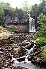 Thornton Force, River Twiss, Ingleton
geo.wikisort.org - River
The River Twiss is a river in the county of Yorkshire, England. The source of the river is Kingsdale Beck which rises at Kingsdale Head at the confluence of Back Gill and Long Gill in the Yorkshire Dales. Beneath Keld Head, it changes its name to the River Twiss. It has two notable waterfalls, Thornton Force and Pecca Falls, and its course follows part of the Ingleton Waterfalls Walk,[1] then through Swilla Glen to Thornton in Lonsdale and down to Ingleton, where it meets the River Doe to form the River Greta.
| River Twiss | |
|---|---|
 River Twiss and Ingleton Viaduct | |
| Location | |
| Country | England |
| Physical characteristics | |
| Source | |
| • location | Kingsdale Beck, Keld Head |
| • coordinates | 54°11′3″N 2°28′4″W |
| • elevation | 264 metres (866 ft) |
| Mouth | |
• location | River Doe |
• coordinates | 54°9′11″N 2°28′15″W |
• elevation | 118 metres (387 ft) |
| Length | 4.17 kilometres (2.59 mi) |
The English landscape artist J. M. W. Turner was a frequent visitor to the area and his sketch of Thornton Force in 1816 is currently part of the Tate collection.[2]
Course
From the caves below Keld Head there is a flow of water that joins Kingsdale Beck to form the River Twiss. It flows south over Thornton Force and Pecca Falls and through woodland to join the River Doe at Ingleton.[3]
Waterfalls
The drop of Thornton Force is about 14 metres (46 ft). Pecca Falls has three drops totalling 30 metres (98 ft) that fall into their own deep pools.[4]
Geology
In its upper part the river runs through a valley cut into horizontal beds of Carboniferous Great Scar limestone. At Thornton Force it crosses a notable unconformity into the underlying, steeply inclined Ordovician greywackes. The unconformity is clearly visible in the face of the waterfall. The Ordovician strata influence the character of the steep and narrow Swilla Glen and its waterfalls until, just north of Ingleton, the river crosses the Craven Fault and onto Carboniferous Limestone once again.[4]
Crossings
- Ravenray Bridge (foot)
- Pecca Bridge (foot)
- Manor Bridge (foot)
- Unnamed Road, Ingleton
Gallery
River Twiss Images


Sources
Ordnance Survey Open Data https://www.ordnancesurvey.co.uk/business-government/tools-support/open-data-support
References
- "Ingleton Waterfalls Walk". Archived from the original on 2 October 2011. Retrieved 20 August 2011.
- "Landscape". Retrieved 20 August 2011.
- "River course" (PDF). Archived from the original (PDF) on 29 September 2011. Retrieved 20 August 2011.
- "Waterfalls". Archived from the original on 9 July 2013. Retrieved 20 August 2011.
На других языках
[de] River Twiss
Der River Twiss ist ein kleiner Fluss in North Yorkshire, England. Der River Twiss wird in seinem Oberlauf auch Kingsdale Beck genannt und wird am Kingsdale Head aus dem Buck Beck und dem Long Gill, die von der Westflanke des Whernside fließen und dem Back Gill gebildet.- [en] River Twiss
Текст в блоке "Читать" взят с сайта "Википедия" и доступен по лицензии Creative Commons Attribution-ShareAlike; в отдельных случаях могут действовать дополнительные условия.
Другой контент может иметь иную лицензию. Перед использованием материалов сайта WikiSort.org внимательно изучите правила лицензирования конкретных элементов наполнения сайта.
Другой контент может иметь иную лицензию. Перед использованием материалов сайта WikiSort.org внимательно изучите правила лицензирования конкретных элементов наполнения сайта.
2019-2026
WikiSort.org - проект по пересортировке и дополнению контента Википедии
WikiSort.org - проект по пересортировке и дополнению контента Википедии