geo.wikisort.org - River
The Harlem River is an 8-mile (13 km) tidal strait in New York, United States, flowing between the Hudson River and the East River and separating the island of Manhattan from the Bronx on the New York mainland.
| Harlem River | |
|---|---|
 The Washington, Alexander Hamilton, and High Bridges over the Harlem River | |
 The Harlem River, shown in yellow, between the Bronx and Manhattan in New York City | |
| Location | |
| Country | United States |
| State | New York |
| Municipality | New York City |
| Physical characteristics | |
| Source | Hudson River |
| • coordinates | 40.87843°N 73.92594°W |
| Mouth | East River |
• coordinates | 40.78003°N 73.93710°W |
| Length | 8 mi (13 km) |
| Basin features | |
| Tributaries | |
| • left | Bronx Kill |
The northern stretch, also called the Spuyten Duyvil ("spewing devil") Creek, has been significantly altered for navigation purposes. Originally it curved around the north of Marble Hill, but in 1895 the Harlem River Ship Canal was dug between Manhattan and Marble Hill, and in 1914 the original course was filled in.
Use
Harlem River Drive and Harlem River Greenway run along the west bank of the river, and the Metro-North Railroad's Hudson Line and Major Deegan Expressway on the east.
The Harlem River was the traditional rowing course for New York, analogous to the Charles River in Boston and the Schuylkill River in Philadelphia. On the Harlem's banks is the boathouse for the Columbia University crew, and the river is the home course for the university's crew. Since 1952, a large flat rock face, called the "(Big) C Rock" has been painted with Columbia's varsity "C".[1] Also on the river are the Peter Jay Sharp Boathouse and Harlem River Community Rowing, two community rowing facilities. The river is used by crews from New York University, Fordham University, and Manhattan College, though the only university with permanent facilities on the river is Columbia.[citation needed]
Historically, the west bank of the Harlem River was also an amusement destination. The area between 190th and 192nd Streets was occupied by the Fort George Amusement Park, a trolley park/amusement park, from 1895 to 1914. Its site is now a seating area in Highbridge Park.[2] In the 1890s, the City of New York built a racetrack for horses, the Harlem River Speedway, along the riverbank of the park;[3] the project started construction in 1894[4] and opened in July 1898.[5] The Speedway later became the Harlem River Drive, and regular motorists were first allowed on the drive in 1919.[6]
Crossings
Harlem River | |||||||||||||||||||||||||||||||||||||||||||||||||||||||||||||||||||||||||||||||||||||||||||||||||||||||||||||||||||||||||||||||||||||||||||||||||||||||||||||||||||||||||||||||
|---|---|---|---|---|---|---|---|---|---|---|---|---|---|---|---|---|---|---|---|---|---|---|---|---|---|---|---|---|---|---|---|---|---|---|---|---|---|---|---|---|---|---|---|---|---|---|---|---|---|---|---|---|---|---|---|---|---|---|---|---|---|---|---|---|---|---|---|---|---|---|---|---|---|---|---|---|---|---|---|---|---|---|---|---|---|---|---|---|---|---|---|---|---|---|---|---|---|---|---|---|---|---|---|---|---|---|---|---|---|---|---|---|---|---|---|---|---|---|---|---|---|---|---|---|---|---|---|---|---|---|---|---|---|---|---|---|---|---|---|---|---|---|---|---|---|---|---|---|---|---|---|---|---|---|---|---|---|---|---|---|---|---|---|---|---|---|---|---|---|---|---|---|---|---|---|
| |||||||||||||||||||||||||||||||||||||||||||||||||||||||||||||||||||||||||||||||||||||||||||||||||||||||||||||||||||||||||||||||||||||||||||||||||||||||||||||||||||||||||||||||
The Harlem River is spanned by seven swing bridges, four lift bridges, and four arch bridges,[7] and is navigable to any boat with less than 55 feet (16.8 m) of air draft. However, any boat requiring more than 5 feet (1.5 m) of clearance will require the Spuyten Duyvil Bridge to swing open. All other movable bridges on the Harlem River provide at least 24 feet (7.3 m) of clearance while closed, so boats and ships requiring between 5 and 24 feet (1.5 and 7.3 m) of clearance need only have one bridge swing open. These bridges replaced fixed bridges or lower bridges in the late 19th century to improve navigation. High Bridge was erected between 1837 and 1848 to carry the Croton Aqueduct across the river. It is the oldest bridge in New York City.
The New York City Department of Transportation advises that while they make every effort to ensure that all bridges are operating, many of them are under repair at any time, and outside contractors are responsible for opening of bridges under repair.
| Crossing | Image | Carries | Location | Coordinates |
|---|---|---|---|---|
| Wards Island Bridge |  
Top: closed position |
Pedestrian/bicycle | Manhattan and Wards Island | 40.7861°N 73.9371°W |
| Robert F. Kennedy Triboro Lift Bridge (Harlem Lift Bridge) |  |
NY State Route 900G (6 road lanes) | Manhattan and Randall's Island | 40.8003°N 73.9278°W |
| Willis Avenue Bridge |   bottom: 2010 bridge |
Northbound auto traffic; Pedestrian/bicycle | Manhattan and the Bronx | 40.8035°N 73.9289°W |
| Third Avenue Bridge |  |
Southbound auto traffic; Pedestrian/bicycle | Manhattan and the Bronx | 40.8076°N 73.9325°W |
| Lexington Avenue Tunnel | IRT Lexington Avenue Line ( |
Manhattan and the Bronx | 40.8095°N 73.9332°W | |
| Park Avenue Bridge |  |
Metro-North Railroad | Manhattan and the Bronx | 40.8111°N 73.9333°W |
| Madison Avenue Bridge |  |
Southbound/eastbound auto traffic; pedestrian/bicycle | Manhattan and the Bronx | 40.8115°N 73.9327°W |
| 149th Street Tunnel | IRT White Plains Road Line ( |
Manhattan and the Bronx | 40.8189°N 73.9331°W | |
| 145th Street Bridge |  |
Westbound/eastbound auto traffic; pedestrian/bicycle | Manhattan and the Bronx | 40.8195°N 73.9331°W |
| Macombs Dam Bridge |  |
Westbound/eastbound auto traffic; pedestrian/bicycle | Manhattan and the Bronx | 40.8281°N 73.9339°W |
| Putnam Bridge (1881–1960) |  |
Ninth Avenue El | Manhattan and the Bronx | 40.8322°N 73.9343°W |
| Concourse Tunnel | IND Concourse Line ( |
Manhattan and the Bronx | 40.8306°N 73.9341°W | |
| High Bridge |  |
Pedestrian | Manhattan and the Bronx | 40.8423°N 73.9303°W |
| Alexander Hamilton Bridge |  |
Manhattan and the Bronx | 40.8456°N 73.9287°W | |
| Washington Bridge |  |
Westbound/eastbound auto traffic; pedestrian/bicycle | Manhattan and the Bronx | 40.8469°N 73.9281°W |
| University Heights Bridge |  |
Westbound/eastbound auto traffic; pedestrian/bicycle | Manhattan and the Bronx | 40.8628°N 73.9150°W |
| Broadway Bridge |  |
IRT Broadway – Seventh Avenue Line ( |
Manhattan Island and Marble Hill, Manhattan | 40.8736°N 73.9111°W |
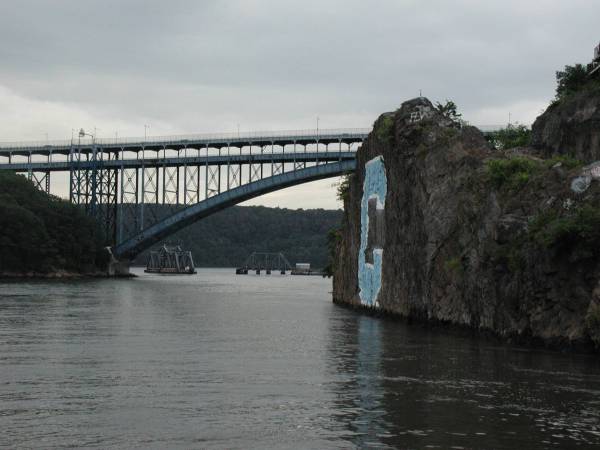
| Henry Hudson Bridge |  |
Manhattan and the Bronx | 40.8779°N 73.9218°W | |
| Spuyten Duyvil Bridge |  |
Amtrak Empire Connection | Manhattan and the Bronx | 40.8783°N 73.9256°W |
See also
- Geography of New York City
- Geography of New York Harbor
- List of New York rivers
References
Notes
- Alma's Owl (pseudonym), "Down by the 'C' Shore", "Ask Alma's Owl" column, Columbia University Record, 32:14:1 (June 11, 2007)
- Martens, Victoria (August 1, 2019). "Fort George Amusement Park". Museum of the City of New York. Retrieved September 2, 2019.
- Gray, Christopher (July 13, 1997). "A Roadway Built for the Elite to Trot Out Their Rigs". The New York Times. ISSN 0362-4331. Retrieved September 15, 2017.
- "CHEERS FROM UNEMPLOYED; 1,500 SAW MAYOR GILROY BEGIN WORK ON THE SPEEDWAY. Hundreds of Idle Workmen Gathered in the Hope of Getting Work, but Active Construction of the Drive Will Not Begin Until To-day or To-morrow -- The Mayor Made a Short Speech of Congratulation -- Stories Told by Unemployed". The New York Times. February 6, 1894. ISSN 0362-4331. Retrieved September 15, 2017.
- "HARLEM SPEEDWAY OPENED; Pronounced by Horsemen to be the Finest Driveway for Light Speeding in the Country. YESTERDAY THE FIRST DAY The Number Present at the Opening Hour Not Large, but Later in the Day Many Wrote Arrived -- Interesting Facts". The New York Times. July 3, 1898. ISSN 0362-4331. Retrieved September 15, 2017.
- Robinson, Lauren (February 28, 2012). "How Harlem River Speedway Became Harlem River Drive". Museum of the City of New York.
- Sharon Reier: The Bridges of New York: Dover Press; 1977.
This article needs additional citations for verification. (November 2010) |
Further reading
- Botella, Rodrigue Ruiz (October 27, 2019). Harlem River. ISBN 978-1-702-82578-8., a novel that highlights the Harlem River and its surroundings
External links
 Media related to Harlem River at Wikimedia Commons
Authority control | |
|---|---|
| General |
|
| National libraries | |
| Other | |
На других языках
[de] Harlem River
Der Harlem River ist ein Meeresarm in New York City, USA, der sich bei einer durchschnittlichen Breite von 120 Metern über 13 Kilometer zwischen dem East River und dem Hudson River erstreckt. Trotz des Namens ist der Harlem River kein Fluss.- [en] Harlem River
[es] Río Harlem
El río Harlem es un estrecho en la Ciudad de Nueva York, EE. UU. que fluye a lo largo de 8 millas (13 km) entre los ríos Este y Hudson, separando los distritos de Manhattan y el Bronx. Parte del curso de la corriente del río Harlem es el canal navegable del río Harlem (Harlem River Ship Canal, en inglés), que se extiende al sur del antiguo curso del río, aislando junto con el arroyo Spuyten Duyvil una pequeña parte de Manhattan (Marble Hill) en el lado del Bronx.[it] Fiume Harlem
Il fiume Harlem (in inglese Harlem River) è un canale naturale situato a nord dell'isola di Manhattan separandola dal Bronx. Assieme allo Spuyten Duyvil Creek connette il fiume Hudson con l'East River, che nonostante il nome “River” non è un fiume ma uno stretto.[ru] Харлем (пролив)
Ха́рлем[1] (англ. Harlem River[2]) — 13-километровый пролив в Нью-Йорке, США, протекающий между рекой Гудзон и проливом Ист-Ривер и отделяющий остров Манхэттен от Бронкса, расположенного на материковой части Нью-Йорка.Другой контент может иметь иную лицензию. Перед использованием материалов сайта WikiSort.org внимательно изучите правила лицензирования конкретных элементов наполнения сайта.
WikiSort.org - проект по пересортировке и дополнению контента Википедии