geo.wikisort.org - River
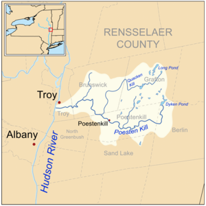
The Poesten Kill is a 26.2-mile-long (42.2 km)[1] creek in upstate New York located entirely in Rensselaer County, which flows westerly from its source at Dyken Pond in the town of Berlin to its mouth at the Hudson River in the city of Troy. It has been used historically as a source of water for local inhabitants and farmers and became even more important as a source of water power during the Industrial Revolution, during which many mills and factories sprung up along its banks.
This article's tone or style may not reflect the encyclopedic tone used on Wikipedia. (July 2022) |
| Poesten Kill | |
|---|---|
 Poesten Kill adjacent to New York Route 2 in Brunswick | |
 Watershed of the Poesten Kill and its tributaries | |
| Location | |
| Country | United States |
| State | New York |
| Region | Rensselaer County |
| Physical characteristics | |
| Source | Dyken Pond |
| • location | Berlin, New York, United States |
| • coordinates | 42°43′2.74″N 73°25′40.58″W |
| • elevation | 1,624 ft (495 m) |
| Mouth | Hudson River |
• location | Troy, New York, United States |
• coordinates | 42°43′14.49″N 73°41′54″W |
• elevation | 0 ft (0 m) |
| Length | 26.2 mi (42.2 km) |
| Basin size | 89.4 sq mi (232 km2) |
| Discharge | |
| • average | 130 cu ft/s (3.7 m3/s) |
| • maximum | 2,897 cu ft/s (82.0 m3/s) |
| Basin features | |
| River system | Hudson River Watershed |
| Tributaries | |
| • left | Newfoundland Creek |
| • right | Bonesteel Creek, Quacken Kill, Sweet Milk Creek |
Its name is derived from a local farmer and miller, Jan Barensten Wemple also known by the nickname "Wemp" or "Poest", that lived near the creek in the 1660s, and the Dutch word kill, meaning creek.[2]
Geography
The Poesten Kill begins at Dyken Pond, a man-made body of water located in the Petersburg Mountains, about 20 miles (32 km) east of the Hudson River, which was created by the Manning Paper Company in 1902 in an effort to control stream flow and prevent flooding.[3] Dyken Pond is fed by local streams and springs and is located near the corners of the towns of Grafton, Berlin, and Poestenkill at an elevation of 1,624 feet (495 m).[4][5]
While many small streams discharge into the Poesten Kill, there are only four notable tributaries of the creek. Bonesteel Creek runs southerly from Bonesteel and Hosjord Ponds and connects with the Poesten Kill in the town of Poestenkill between the hamlets of Barberville and Ives Corner.[n 1] Bonesteel Creek is about 5.4 miles (8.7 km) long.[6] Newfoundland Creek is the next tributary and joins the Poesten Kill just west of the hamlet of Poestenkill. It is about 3.6 miles (5.8 km) long.[6] The Quacken Kill is the next tributary and connects in the town of Poestenkill near the Brunswick border.[n 2] The Quacken Kill begins at Long Pond at Grafton Lakes State Park and continues through Second Pond and Mill Pond, also in the park, before continuing through Dunham Reservoir near central Grafton. It is about 15.9 miles (25.6 km) long.[6] The next major tributary is Sweet Milk Creek, which begins as a stream in north central Brunswick and travels about 4.7 miles (7.6 km)[6] before combining in the southwestern portion of the town.[n 3][5]
The Poesten Kill travels about 26.2 miles (42.2 km) through Rensselaer County before flowing into the Hudson River.[1]
Between 1924 and 1968, and at a location between Eagle Mills and Troy,[n 4] the Poesten Kill saw an average of 130 cu ft/s (3.7 m3/s) in flow.[7] It saw an average of 2,897 cu ft/s (82.0 m3/s) for peak flow in the same time period.[8]
Waterfalls
There are a number of notable waterfalls along the course of the Poesten Kill and its tributaries.
 Barberville Falls in Poestenkill
 High Falls in Troy


History
The Dutch

Prior to the arrival of Europeans, the Mohicans occupied the land through which the Poesten Kill flows. The first permanent European settlement in the area was Fort Orange, a trading post built by the Dutch West India Company in 1624, about 10 miles (16 km) south of the mouth of the creek.[9] However, the mouth of the Poesten Kill at the Hudson is said to be first genuine European frontier settlement outside the barricades of Fort Orange.[10]
The land making up much of current-day Albany and Rensselaer counties was sold by the Mohicans in 1630 to Kiliaen van Rensselaer, a Dutch merchant and businessman.[11] With the land, Van Rensselaer began the only successful patroonship – essentially a feudal manor – in the history of the Dutch colonies: Rensselaerswyck.[12] Van Rensselaer named the land surrounding the mouth of the Poesten Kill Pafraets Dael after his mother, Maria Pafraet.[13] This can be seen on the first map of Rensselaerswyck, though the Poesten Kill is not identified.[9]
The Dutch can be credited for the source of the creek's name. In 1661, Jan Barentse Wemp, an independent farmer-trader, began a lease for a farm with Jan Baptist van Rensselaer,[14] Kiliaen's oldest son and the patroon at the time.[15] The land extended south from the Poesten Kill to the north bank of the Wynants Kill, which empties into the Hudson in South Troy. At the time, residents would commonly go by a recognizable nickname, to distinguish themselves in local records. Wemp went by "Poest". Add the Dutch word kill, meaning "creek", and the source of the name Poesten Kill becomes clear.[14]
While most of the settlements along or near the Poesten Kill during the Dutch era revolved around farming, some were also based on easy access to the Mohicans for trade in fur. The Indians, likewise, were more than happy to cut their trip by miles, since they would no longer have to go to Fort Orange.[16] At the time, the fur trade was legally monopolized by the Dutch West India Company, so this practice was illegal, but very profitable.[17]
Rensselaerswyck was taken over by the English in 1664,[18] though the legal existence of the patroonship was not challenged.[19]
In the 1600s, a sawmill was built at the base of Poestenkill falls by Jan Barensten Wemple and was passed on to his wife, Marytie Mynderse after his passing.[20]
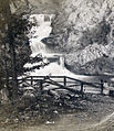
In the 1800s, many mills and factories were built along this river to use water power or have easy access to the Hudson on a riverside road beginning just after Poestenkill Falls.[21] This included a bridge that spanned the creek just after the falls, and this bridge is no longer around but remains of the old factories still can be seen along the north side of the river. Small dirt paths are all that is left of the roads on the north side of the creek between the falls and prospect park.
Dangers of the Falls
The Poestenkill falls have been always been a sight to see for hikers and the public, but there are dangers associated with climbing and being around the fast waters that flow through the creek after floods and winter thaws. Most recently in February 2017, a young man fell went missing and was found dead in the Hudson days later.[22]
The Poestenkill Gorge Today
Located right behind RPI’s polytechnic dorm. The Poestenkill gorge is also known by many names such as Mount Ida Falls, Wire Mill Falls, and Poestenkill High Falls. It's the largest waterfall found on the Poesten Kill river system, which consists of 6 distinct drops totaling to about 150 feet; the tallest drop at around 30 feet. The average width of the stream is 15 feet with 50 feet being the max in some areas. At the base of the fall, it was mostly pebbles ranging from 1cm pebbles to large boulders. Also at the base, 10 feet above there was a hollow cave-like structure that resembles a rock shelter. It can be accessed from the base through climbing and connects to the upper level of the waterfall where pockets of water lie. The upper portion of these falls is viewable almost completely from a private residence up the hill from the park’s parking area on Linden Ave. There are some other areas to view the waterfalls from the top of the Gorge off of Rt. 2, uphill from the Cookie Factory.
There are two access points located on each side of the river. A private company has a small power station that still produces electricity from hydro power on the north side of the river that was built in the 1950s[23]House Systems - Hydro Projects - Mt. Ida, n.d. http://phshydro.com/mtida.html.</ref> and used turbines inside the remains of the concrete foundation of the old industrial mills. A gate blocked the entrance to this access point but since has been removed. This road existed since the 1870s but had been closed off in the 1990s when the city of Troy discontinued maintenance of this park even though it still owns the land. This road leads to a small dirt path tangled with saplings and roots along old industrial remains from the Marshall Factories. This dirt path is where the bridge access road used to be due to the lack of any full grown trees and a clearing. The path splits into two paths, one leading towards the sublime foundation of an old mill with one brick archway standing. Along the northern riverbank, there is obvious stone bricks, shale from mill foundations, clay bricks from the old mill inscribed “Bleau”, and steel rods from where bridges and walkways used to traverse and cross the gorge. The bricks inscribed “Bleau” were made in a brick factory in Mechanicville across the Hudson[24] and used to make up a mill from the 1700s.
Walking along the riverbank provides no sure footing due to the deposits of rubble and driftwood along the banks. An interesting sight is the rock walls of the waterfalls that indicate all dirt and clay has been washed away by the constant barrage of water. During the spring, melt water and a lack of dam upstream causes the water to flow much more violently, discharging water faster and preventing access to most of the waterfall riverbanks. During the winter, the colder weather along with snow cover much of the surrounding banks, and a thick layer of ice forms across the river. When summer comes, most of the ice from winter has melted and the lower river discharge exposes the banks finally. Students from RPI and the community surrounding the area often come to the gorge to take a drip and to relax during the hot summer days.
See also
Notes
References
- U.S. Geological Survey. National Hydrography Dataset high-resolution flowline data. The National Map, accessed October 3, 2011
- "Jan Barentse WEMPLE b. Abt 1620 Holland d. Aft 18 May 1663 Albany, NY: Salls Family Ancestry". www.salls.org. Retrieved 2020-02-17.
- Warren (2009), p. 18
- Warren (2009), p. 2
- Placeholder for USGS map citation
- U.S. Geological Survey, 2009, National Hydrography Dataset: U.S. Geological Survey dataset available at http://nhd.usgs.gov; Retrieved November 21, 2009.
- "USGS Surface-Water Annual Statistics for the Nation: USGS 01358500 Poesten Kill Near Troy NY". United States Geological Survey. Retrieved 2009-11-15.
- "Peak Streamflow for the Nation: USGS 01358500 Poesten Kill Near Troy NY". United States Geological Survey. Retrieved 2009-11-15.
- Warren (2009), p. 32
- Warren (2009), p. 15
- Van Laer (1908), p. 54
- Van Laer (1908), p. 55
- Van Laer (1908), p. 43
- Warren (2009), p. 35
- Gilbert, Walter. "Kiliaen Van Rensselaer, Anna Van Wely (Walter Gilbert, Ancestors: The Eleventh Generation Back)". Archived from the original on 2009-03-31. Retrieved 2009-07-26.
- Warren (2009), p. 37
- Van Laer (1906), p. 47
- Reynolds (1906), pp. 66
- Warren (2009), p. 39
- Anderson, George Baker. Landmarks of Rensselaer county, New York. (1997). Index to Landmarks of Rensselaer county, New York : by George Baker Anderson, 1897. Berkshire Family History Association. OCLC 38998211.
{{cite book}}: CS1 maint: multiple names: authors list (link) - "Map of Troy, also West Troy, and Green Island". Library of Congress. Retrieved 2020-02-17.
- Twitter, newsroom@Wtroyrecord com @troyrecord on. "Body of Poestenkill Gorge victim found in Hudson River". The Record. Retrieved 2020-02-17.
{{cite web}}:|last=has generic name (help) - Power
- Nadeau, Anne Marie. “My Life in the Brickyard .” Spindle City Historic Society , 2003.
Bibliography
- Van Laer, A. J. F. (translator and editor) (1908). Van Rensselaer Bowier Manuscripts. Albany: University of the State of New York. OCLC 9261526.
The Van Rensselaers in Holland and in America.
{{cite book}}:|first=has generic name (help) - Weise, Arthur James (1886). The city of Troy and its vicinity. Troy, New York: Edward Green. OCLC 8989214.
- Warren, John (2009). The Poesten Kill: Waterfalls to Waterworks in the Capital District. Charleston, South Carolina: The History Press. ISBN 978-1-59629-633-6.
External links
- Barberville Falls at The Nature Conservancy
Другой контент может иметь иную лицензию. Перед использованием материалов сайта WikiSort.org внимательно изучите правила лицензирования конкретных элементов наполнения сайта.
WikiSort.org - проект по пересортировке и дополнению контента Википедии