geo.wikisort.org - River
The Gudbrandsdalslågen (or simply Lågen) is a river which flows through the Gudbrandsdal valley in Innlandet county, Norway. The 204-kilometre (127 mi) long river runs through a large valley in Eastern Norway before emptying into Mjøsa, the largest lake in Norway. The river flows through the municipalities of Lesja, Dovre, Sel, Nord-Fron, Sør-Fron, Ringebu, Øyer, and Lillehammer.[1]
| Gudbrandsdalslågen Lågen | |
|---|---|
 | |
 Location of the river  Gudbrandsdalslågen (Norway) | |
| Location | |
| Country | Norway |
| County | Innlandet |
| Physical characteristics | |
| Source | Lesjaskogsvatnet |
| • location | Lesjaverk, Norway |
| • coordinates | 62.1893977°N 8.53775024°E |
| • elevation | 611 metres (2,005 ft) |
| Mouth | Mjøsa |
• location | Jørstadmoen, Norway |
• coordinates | 61.127987°N 10.4061126°E |
• elevation | 121 metres (397 ft) |
| Length | 204 km (127 mi) |
| Basin size | 11,459 km2 (4,424 sq mi) |
| Discharge | |
| • average | 255 m3/s (9,000 cu ft/s) |
Watercourse

The Gudbrandsdalslågen begins in the lake Lesjaskogsvatnet (or Lesjavatn), which lies in Lesja municipality in the far northern part of the county. Lesjavatn is the only lake in Norway which has two outlets, and they both flow into two of Norway’s more famous rivers. In the southeast at the village of Lesjaverk, the lake serves as the headwaters for the Gudbrandsdalslågen, while in the northwest at Lesjaskog village, Lesjavatn is the headwaters for the Rauma river which heads to the west.
The Gudbrandsdalslågen river flows through the Gudbrandsdal valley. Western tributaries of the Gudbrandsdalslågen include the Gausa River flowing through the Gausdal valley, the Otta River flowing through the Ottadalen valley, the Vinstra River flowing through Vinstradalen, and the Sjoa River, flowing through the Heidal valley. The eastern rivers, Jora, Ula, Frya, Tromsa, and Mesna are shorter and drop precipitously from the heights of the Rondane mountains. Although relatively placid for extended stretches of its 204-kilometre (127 mi) path, the Gudbrandsdalslågen drops rapidly through the Rosten Gorge in Sel Municipality.[2]
Between the municipalities of Ringebu and Øyer the river widens out and creates the large so-called "riverlake" Losna).
The Gudbrandsdalslågen terminates in the lake of Mjøsa at the town of Lillehammer. It is the largest river flowing into this lake. The lake which discharges into the short Vorma River which in turn flows into the Glomma River at Nes.[3]
Flooding
Norwegian rivers crest in the spring as the snow melts. The Gudbrandsdalslågen, draining higher elevations and being primarily glacier fed, typically crests later than the Glomma river, which drains the east valleys. In the rare year when both crest at the same time, their confluence at Nes is the site of great floods. The most famous simultaneous crest of the Gudbrandsdalslågen and Glomma rivers resulted in the flood that took place on 20–23 July 1789, with crests over 50 feet (15 m) above the average level of the water. At the lake Øyeren which is beyond Nes there was extensive damage, including 68 casualties.
Bridge Collapses
In 2016 Perkolo Bridge over the Gudbrandsdalslågen at Soja collapsed.The bridge was made of glued laminated timber. After the 2016 collapse, 11 similar bridges, including the one in Tretten, were closed temporarily.[4]
On 15 August 2022 the bridge over the Gudbrandsdalslågen, near the village of Tretten collapsed. The 150m wooden bridge opened in 2012. A lorry driver was rescued by helicopter and a car driver escaped by himself. "It is completely catastrophic, completely unreal," local mayor Jon Halvor Midtmageli told Norway's Dabgladet newspaper. The Tretten bridge was last checked in 2021.[5][6]
Etymology
Lågen is the finite form of låg (Old Norse: lǫgr) which means "water" or "river". The meaning is just 'the river', and this term must have replaced an old name that is now forgotten and unknown. The word lågen is somewhat common in the Norwegian language as a suffix meaning river. The first part of the river name is often the name of the valley in which the river is located (the Gudbrandsdal valley in this case). Examples of this use include Gudbrandsdalslågen, Numedalslågen, and Suldalslågen.[7]
Species
The Hunder trout is bred at the Hunderfossen waterfall on the Gudbrandsdalslågen river, by the 280-metre (920 ft) long power station dam. Next to the dam, there is an outdoor exhibition centre for hunder trout. There is a hatchery on the west bank; it produces 20,000 hunder trout every year and releases them into the river to compensate for the loss of fish and of spawning grounds when the power plant was established.[8]
Media gallery
 Hundertrout spawning
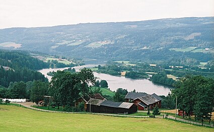 Gudbrandsdalslågen forms a delta where it flows into lake Mjøsa
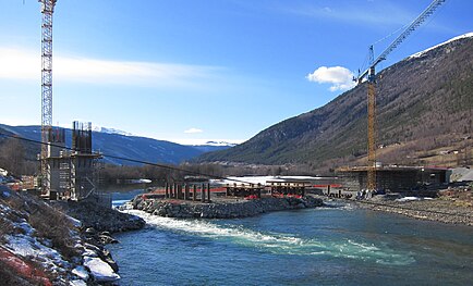 Lågen bridge on road E6 near Kvam under construction in 2015
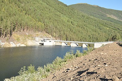 Rosten hydro power reservoir at the upper part of Lågen


See also
- List of rivers in Norway
- Populated places on the Gudbrandsdalslågen river (category)
References
- Lars Mæhlum. "Gudbrandsdalslågen". Store norske leksikon. Retrieved 1 January 2017.
- Lars Mæhlum. "Gausa". Store norske leksikon. Retrieved 1 January 2017.
- Geir Thorsnæs. "Glomma". Store norske leksikon. Retrieved 1 January 2017.
- Jessel, Ella (17 August 2022). "Norway's collapsed timber bridge had 'vulnerabilities', says Arup expert". New Civil Engineer. Archived from the original on 17 August 2022. Retrieved 18 August 2022.
- "Drivers rescued after Norway bridge collapse". BBC News. 15 August 2022. Retrieved 16 August 2022.
- "Car plunges into water as Norwegian bridge collapses". ABC News. 16 August 2022. Retrieved 16 August 2022.
- Børge Nordbø. "Lågen". Store norske leksikon. Retrieved 1 January 2017.
- "Hunder trout". Archived from the original on 17 September 2015.
Related reading
- Stagg, Frank Noel (1956). East Norway and its Frontier. London, UK: George Allen and Unvin, Ltd.
- Welle-Strand, Erling (1996). Adventure Roads in Norway. Nortrabooks. ISBN 9788290103717.
- Fullerton, Brian; Williams, Alan (1972). Scandinavia, An Introductory Geography. New York, USA: Praeger Publishers.
| Authority control |
|
|---|
На других языках
[de] Lågen (Gudbrandsdal)
Lågen (oder Laagen) ist der Name eines wasserreichen Stromes im südlichen Norwegen:- [en] Gudbrandsdalslågen
[es] Gudbrandsdalslågen
El río Gudbrandsdalslågen (o el Lågen[1]) es un río de Noruega que discurre a través del valle de Gudbrandsdal, en el condado de Innlandet. El río, de 204 km de longitud, forma parte del curso alto del río Vorma, a su vez parte de la cuenca del Glomma, y enlaza los lagos de Lesjaskogsvatnet y Mjøsa.[it] Gudbrandsdalslågen
Il Gudbrandsdalslågen o Lågen[1] è un fiume della Norvegia, che scorre nella valle Gudbrandsdalen, nella contea di Innlandet. Nasce dal lago Lesjaskogsvatnet e sfocia nel lago Mjøsa. Il sistema fluviale combinato Gudbrandsdalslågen-Vorma (quest'ultimo emissario del Mjøsa), lungo 351 km, rappresenta il quarto fiume della Norvegia[2].Другой контент может иметь иную лицензию. Перед использованием материалов сайта WikiSort.org внимательно изучите правила лицензирования конкретных элементов наполнения сайта.
WikiSort.org - проект по пересортировке и дополнению контента Википедии