geo.wikisort.org - River
Otta is a river in Innlandet county, Norway. The 147.85-kilometre (91.87 mi) river flows through the Ottadalen valley which includes the municipalities of Skjåk, Lom, Vågå, and Sel. The watershed of the Otta drains an area of 4,172 square kilometres (1,611 sq mi) beginning in the Breheimen mountains and emptying into the large river Gudbrandsdalslågen. The Otta River is known for rafting. The rafting season begins in mid-May and lasts until the end of September. The Norwegian National Road 15 runs along the river for almost its entire course.[1][2]
| Otta | |
|---|---|
 The Otta River near the town of Otta | |
 Location of the river  Otta (river) (Norway) | |
| Location | |
| Country | Norway |
| County | Innlandet |
| Municipalities | Skjåk, Lom, Vågå, and Sel |
| Physical characteristics | |
| Source | Djupvatnet lake |
| • location | Stranda, Norway |
| • coordinates | 62°01′29″N 7°19′21″E |
| • elevation | 1,016 metres (3,333 ft) |
| Mouth | Gudbrandsdalslågen |
• location | Otta, Norway |
• coordinates | 61°46′03″N 9°32′39″E |
• elevation | 210 metres (690 ft) |
| Length | 147.85 km (91.87 mi) |
| Basin size | 4,172 km2 (1,611 sq mi) |
| Discharge | |
| • average | 119.7 m3/s (4,230 cu ft/s) |
Course
The river technically begins at the lake Djupvatnet in Stranda Municipality which is in Vestland county, about 1.5 kilometres (0.93 mi) west of the border with Skjåk Municipality in Innlandet county. The river flows through the Billingsdalen valley heading to the east, including through several lakes including the Breiddalsvatnet, Skim, and Vågåvatn. After the Vågåvatn lake at Vågåmo, it enters the Ottadalen valley and heads to the southeast to the town of Otta in Sel Municipality. At Otta, the river joins the large river Gudbrandsdalslågen.[2]
Name
The name of the river is probably derived from the Old Norse verb ótta which means to "scare" or "terrify". The water of the river comes from glaciers, and the flooding of the river can be strong and fierce.
Media gallery
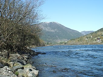 Otta River.
 Aerial view of the Otta River.
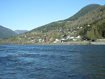 In front of Otta.


See also
- List of rivers in Norway
References
- "NVE Atlas" (in Norwegian). Retrieved 24 April 2022.
- Vinjar, Asbjørn; Thorsnæs, Geir, eds. (13 January 2020). "Otta - elv". Store norske leksikon (in Norwegian). Kunnskapsforlaget. Retrieved 24 April 2022.
This Innlandet location article is a stub. You can help Wikipedia by expanding it. |
This article related to a river in Norway is a stub. You can help Wikipedia by expanding it. |
На других языках
[de] Otta (Fluss)
Die Otta ist ein 150 km langer wasserreicher Wildfluss im norwegischen Innlandet. Sie durchfließt das landschaftlich schöne Hochtal Ottadal und mündet später in der gleichnamigen Stadt Otta in den Lågen. Ruhige seenartige Strecken wechseln sich mit stark verblockten Gefällstrecken ab.- [en] Otta (river)
[ru] Утта (река)
У́тта или О́тта[1][2] (норв. Otta) — река в норвежской фюльке Иннландет, протекает по территории коммун Шок, Лом, Вого и Сель. Правый и крупнейший приток реки Логен[no]. Длина — 147 километров[3], а площадь водосборного бассейна — 4011 км²[3].Другой контент может иметь иную лицензию. Перед использованием материалов сайта WikiSort.org внимательно изучите правила лицензирования конкретных элементов наполнения сайта.
WikiSort.org - проект по пересортировке и дополнению контента Википедии