geo.wikisort.org - River
Numedalslågen is a river located in the counties of Vestfold and Telemark and Viken in southeastern Norway. It is one of the longest rivers in Norway.[1]
| Numedalslågen | |
|---|---|
 Numedalslågen at Godfarfossen | |
| Location | |
| Country | Norway |
| Physical characteristics | |
| Source | |
| • location | Hardangervidda |
| Mouth | |
• location | Larvik, Skagerrak |
| Length | 250 kilometres (160 mi) (approx.) |
Location
Numedalslågen stretches for over 250 kilometres (160 mi) through the counties of Vestfold and Telemark and Viken_(county), beginning at the Hardangervidda plateau and meeting the ocean at Larvik in Vestfold. Numedalslågen is one of Norway's longest rivers. The river runs through the municipalities Larvik, Lardal, Kongsberg, Flesberg, Rollag and Nore og Uvdal. These municipalities cooperate in the administration and use of resources connected to the river in various projects under the Green Valley (Grønn Dal) umbrella.
There are a number of hydroelectric plants in the higher range of Numedalslågen. Most of the power potential of the main river is developed, except the stretch between Hvittingfoss and Larvik and Godfarfossen in Dagali. Nore I kraftverk, the first power plant built in the Nore municipality in Viken used Norefallene between Tunhovdfjorden and Rødberg. It was completed in 1928 and was designed by Norwegian architects Carl Buch and Lorentz Harboe Ree. Nore II kraftverk uses the drop between Rødberg dam and Norefjord and was completed in 1947.
Numedalslågen is known for being a good location for salmon fishing, although a parasite known as Gyrodactylus salaris has recently been found in Numedalslågen that may pose a threat to its salmon stock. Among the other fish species of Numedalslågen are trout, eel, and pike.[2][failed verification]
Name
The first element is name of the Numedal River. The second element is the finite form of låg (Norse 'lǫgr m) "water; river", but the river was originally called Nauma and is the origin of the valley's name.
Gallery
 Numedalslågen through Kongsberg
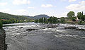 Nybrufoss on Numedalslågen
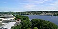 Numedalslågen through Larvik
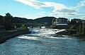 Numedalslågen in Kongsberg
 Numedalslågen at Skjønne
 Numedalslågen at Komnes in Sandsvær


See also
References
- Geir Thorsnæs. "Numedalslågen". Store norske leksikon. Retrieved November 1, 2016.
- "Oppvandring av radiomerket laks i Numedalslågen i 2003 (Norsk institutt for naturforskning. 2003)" (PDF). Archived from the original (PDF) on 2005-02-01. Retrieved 2011-04-29.
Other sources
- Nasjonalgalleriet and Riksantikvaren (1982) Norsk Kunstnerleksikon (Oslo: Universitetsforlaget) ISBN 82-00-05689-9
- Tråen, Even, Tor Bjørvik & Sølver Sjulstad (2001) Livet langs Numedalslågen (Oslo) ISBN 82-996056-0-1
На других языках
[de] Lågen (Numedal)
Der Numedalslågen ist mit seinen 352 km einer der längsten Flüsse Norwegens. Er hat seinen Ursprung in der Hardangervidda und fließt von dort durch das Sæterdalen nach Dagali, weiter ins Numedal bis Kongsberg, bildet unter mehreren Wasserfällen den Labrofoss und fließt weiter bis Larvik, wo er in die Nordsee (Skagerrak) mündet. Der Fluss hat ein Einzugsgebiet von 5554 km².- [en] Numedalslågen
[es] Numedalslågen
El río Numedalslågen es un importante río costero del sureste de Noruega, que discurre por los condados de Vestfold og Telemark y Viken. Con un curso de 359 km, es uno de los ríos más largos del país, comenzando en la meseta de Hardangervidda y desembocando en aguas del Skagerrak en Larvik (Vestfold). En el curso alto del Numedalslågen se han construido una serie de centrales hidroeléctricas.[it] Numedalslågen
Il Numedalslågen è un fiume della Norvegia meridionale, che scorre tra le contee di Viken e Vestfold og Telemark.[ru] Логен
Ло́ген[1][2][3], или Ну́медалсло́ген[2][4], (норв. Lågen, Numedalslågen) — река в Норвегии[5].Другой контент может иметь иную лицензию. Перед использованием материалов сайта WikiSort.org внимательно изучите правила лицензирования конкретных элементов наполнения сайта.
WikiSort.org - проект по пересортировке и дополнению контента Википедии