geo.wikisort.org - River
The Dirty Devil River is an 80-mile-long (130 km) tributary of the Colorado River, located in the U.S. state of Utah. It flows through southern Utah from the confluence of the Fremont River and Muddy Creek before emptying into the Colorado River at Lake Powell.
| Dirty Devil River | |
|---|---|
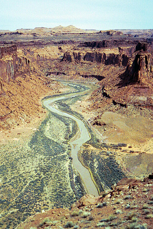 The Dirty Devil River near Twin Corral Box Canyon | |
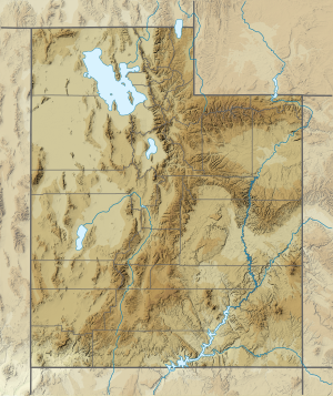 Location of the mouth of the Dirty Devil River in Utah | |
| Location | |
| Country | United States |
| State | Utah |
| County | Wayne County, Garfield County |
| Physical characteristics | |
| Source | Confluence of Fremont River and Muddy Creek |
| • location | Wayne County, Utah |
| • coordinates | 38°24′9″N 110°41′35″W[1] |
| • elevation | 4,266 ft (1,300 m)[2] |
| Mouth | Colorado River |
• location | Lake Powell, Glen Canyon National Recreation Area, Garfield County, Utah |
• coordinates | 37°53′30″N 110°23′33″W[1] |
• elevation | 3,703 ft (1,129 m)[3] |
| Length | 80 mi (130 km)[4] |
| Discharge | |
| • average | 101 cu ft/s (2.9 m3/s)[5] |
| • minimum | 0 cu ft/s (0 m3/s) |
| • maximum | 35,800 cu ft/s (1,010 m3/s) |
| Basin features | |
| Tributaries | |
| • left | Muddy Creek |
| • right | Fremont River |
Course
The Dirty Devil River is formed in Wayne County near Hanksville at the confluence of the Fremont River and Muddy Creek. It flows generally southward through a 2,000-foot-deep (610 m) canyon in Wayne and Garfield counties. Its lower 20 miles (32 km) flows through Glen Canyon National Recreation Area, where it finally disembogues into the Colorado River at a point that is now submerged beneath Lake Powell.
The canyon carved by the river is particularly isolated and seldom visited compared to other natural areas in the region. The average discharge is approximately 446 cubic feet per second.
History

The Dirty Devil River was named by the 1869 Powell Geographic Expedition led by John Wesley Powell, which explored much of the Colorado River and its tributaries. It was named for the extreme salinity and turbidity of the water near its mouth. Powell later contrasted it with a much cleaner stream in the Grand Canyon, which he named Bright Angel Creek.[6]
The outlaw Butch Cassidy and his gang used tributary canyons of the Dirty Devil, such as Robbers Roost, as a hideout in the 1890s.[6]
Geology
The Dirty Devil River and its tributaries contribute approximately 150,000 tons of salt to the Colorado River each year, with the Muddy Creek tributary contributing an annual average of 86,000 tons by itself. The Fremont River tributary does not contribute significant amounts of salt. The United States Bureau of Reclamation has created a plan to reduce the salinity of the Dirty Devil River by collecting salty spring water and using deep-well injection to dispose of it. The plan, completed in 1987, has not been implemented due to its marginal cost effectiveness.[7]
Bridges
The river is spanned by a bridge a few miles northwest of the Hite Crossing Bridge, a steel arch bridge over the Colorado River on State Route 95 near milepost 45 in Garfield County. It is also spanned by the Utah Hwy 24 bridge a few miles NE of Hanksville, UT, just downstream from the confluence of Muddy Creek and the Fremont river.
See also
- List of Utah rivers
- List of tributaries of the Colorado River
References
- U.S. Geological Survey Geographic Names Information System: Dirty Devil River
- Source elevation derived from Google Earth search using GNIS source coordinates.
- Mouth elevation derived from Google Earth search using GNIS mouth coordinates.
- Dirty Devil River Archived March 19, 2006, at the Wayback Machine, The Columbia Gazetteer of North America
- http://wdr.water.usgs.gov/wy2013/pdfs/09333500.2013.pdf [bare URL PDF]
- Dirty Devil River Archived 2008-11-17 at the Wayback Machine, Bureau of Land Management
- Colorado River Basin Salinity Control Program, Dirty Devil, Utah, USBR
Colorado River system | |||||||||
|---|---|---|---|---|---|---|---|---|---|
| Jurisdictions |
|     | |||||||
| Canyons |
| ||||||||
| Natural features |
| ||||||||
| Tributaries |
| ||||||||
| Engineering |
| ||||||||
| Designated areas |
| ||||||||
| Related topics |
| ||||||||
Authority control | |
|---|---|
| General |
|
| National libraries | |
На других языках
[de] Dirty Devil River
Der Dirty Devil River ist ein rechter Nebenfluss des Colorado River mit einer Länge von ungefähr 129 km im zentralen Südutah. Er entsteht im Wayne County nahe Hanksville durch den Zusammenlauf der Flüsse Fremont River und Muddy Creek. Der Dirty Devil River fließt durch einen 600 m tiefen Canyon im Garfield County und im Wayne County. Auf seinen letzten 32 km durchfließt er das Glen Canyon National Recreation Area, bevor er in den Colorado River mündet. Er entwässert ein Gebiet von 1945 km².- [en] Dirty Devil River
[it] Dirty Devil
Il Dirty Devil è un affluente di destra del Colorado, che scorre nella regione centromeridionale dello Utah, negli Stati Uniti. Nasce dalla confluenza dei fiumi Fremont e Muddy Creek, presso Hanksville. Il fiume scorre in un canyon profondo 600 m nelle contee di Wayne e Garfield. L'ultimo tratto di 32 km è compreso nell'area protetta del Glenn Canyon Recreation Area, dove il Dirty Devil confluisce nel lago Powell.Другой контент может иметь иную лицензию. Перед использованием материалов сайта WikiSort.org внимательно изучите правила лицензирования конкретных элементов наполнения сайта.
WikiSort.org - проект по пересортировке и дополнению контента Википедии