geo.wikisort.org - River
The Fremont River is a 95-mile (153 km) long river in southeastern Utah, United States that flows from the Johnson Valley Reservoir, which is located on the Wasatch Plateau near Fish Lake, southeast through Capitol Reef National Park to the Muddy Creek near Hanksville where the two rivers combine to form the Dirty Devil River, a tributary of the Colorado River.[2][3][4][5]
| Fremont River | |
|---|---|
 Looking south along the Fremont River near Caineville, February 2005 | |
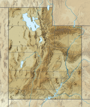 Location of the mouth of the Fremont River in Utah | |
| Etymology | John C. Frémont |
| Location | |
| Country | United States |
| State | Utah |
| Region | Sevier and Wayne counties |
| Physical characteristics | |
| Source | |
| • location | Johnson Valley Reservoir |
| • coordinates | 38°36′32″N 111°37′56″W |
| • elevation | 8,819 ft (2,688 m) |
| Mouth | Dirty Devil River |
• location | near Hanksville |
• coordinates | 38°24′10″N 110°41′35″W |
• elevation | 4,250 ft (1,300 m) |
| Length | 95 mi (153 km) |
| Basin size | 751 sq mi (1,950 km2) |
| Discharge | |
| • location | Bicknell[1] |
| • average | 83.9 cu ft/s (2.38 m3/s)[1] |
| • minimum | 18 cu ft/s (0.51 m3/s) |
| • maximum | 1,360 cu ft/s (39 m3/s) |
Course
The Johnson Valley Reservoir is fed by Sevenmile Creek (from the north) and Lake Creek (from the southwest). The Fremont River passes through Fremont, Loa, Lyman, Bicknell, Teasdale, and Torrey and provides year-round irrigation for the agricultural lands of Rabbit Valley and Caineville. Then it heads through Hanksville and afterward to its mouth.
Miscellaneous
The Fremont River has a drainage area of 751 square miles (1,950 km2) fed by spring snowmelt off Thousand Lake Mountain, Boulder Mountain, and the northern Henry Mountains. The river is named after John Charles Frémont.[4] It gives its name to the Fremont culture, a Precolumbian archaeological culture.
Flow
Flow (ft^3/s), by month (1977–2003), at Bicknell gauging station:[1]
| Month | Mean | Min | Max |
|---|---|---|---|
| January | 85.6 | 54.1 | 145.0 |
| February | 90.9 | 59.7 | 140.0 |
| March | 86.6 | 63.7 | 133.0 |
| April | 89.2 | 66.1 | 131.0 |
| May | 96.2 | 70.0 | 135.0 |
| June | 112.0 | 66.4 | 243.0 |
| July | 119.0 | 63.3 | 412.0 |
| August | 86.4 | 58.7 | 163.0 |
| September | 70.7 | 46.1 | 174.0 |
| October | 67.5 | 50.7 | 135.0 |
| November | 74.2 | 46.3 | 139.0 |
| December | 77.0 | 51.4 | 119.0 |
See also
- List of Utah rivers
- List of tributaries of the Colorado River
References
- Water-Data Report 2013: 09330000 Fremont River near Bicknell, UT (PDF). water.usgs.gov (Report). United States Geological Survey. 2013. Retrieved 9 Feb 2018.
- "The National Map". United States Geological Survey. Archived from the original on 29 March 2012. Retrieved 16 Feb 2011.
- Fremont River Watershed: Water Quality Management Plan. waterquality.utah.gov (Report). Utah Department of Environmental Quality: Division of Water Quality. 27 Sep 2002. p. 1. Archived from the original (PDF) on 18 March 2005. Retrieved 9 Feb 2018.
- "Fremont River". nps.gov. National Park Service. 25 Feb 2012. Retrieved 9 Feb 2018.
- "Fremont River". Geographic Names Information System. United States Geological Survey, United States Department of the Interior.
External links
![]() Media related to Fremont River (Utah) at Wikimedia Commons
Media related to Fremont River (Utah) at Wikimedia Commons
Authority control | |
|---|---|
| General |
|
| National libraries | |
This article related to a river in Utah is a stub. You can help Wikipedia by expanding it. |
На других языках
[de] Fremont River
Der Fremont River ist ein Fluss im US-Bundesstaat Utah. Er fließt vom Johnson Valley Reservoir in der Nähe des Fish Lakes durch den Capitol-Reef-Nationalpark. Bei Hanksville mündet der 115 Kilometer lange Muddy Creek in den Fluss und zusammen bilden sie den Dirty Devil River, welcher in den Colorado River mündet.- [en] Fremont River (Utah)
[it] Fremont (fiume)
Il Fremont è un fiume che scorre nella regione centrale dello Utah, negli Stati Uniti. Fuoriesce dal lago artificiale del Johnson Valley Reservoir, posto a nord-est del lago Fish, e attraversa il parco nazionale di Capitol Reef in direzione sud-ovest. Dalla confluenza col Muddy Creek presso Hanksville, dà origine al fiume Dirty Devil, un affluente di destra del Colorado. Il fiume Fremont attraversa la contea di Wayne e le città di Fremont, Loa, e Torrey. Il bacino del fiume Fremont raccoglie le acque superficiali e di scioglimento primaverile delle nevi provenienti dai rilievi di Thousand Lake Mountain, Boulder Mountain e delle Henry Mountains.Другой контент может иметь иную лицензию. Перед использованием материалов сайта WikiSort.org внимательно изучите правила лицензирования конкретных элементов наполнения сайта.
WikiSort.org - проект по пересортировке и дополнению контента Википедии