geo.wikisort.org - River
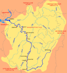
The Belaya (Russian: Бе́лая, romanized: Belaja; Bashkir: Ағиҙел, romanized: Ağiźel, lit. 'Ağiðel' [ä.ʁi̠.ˈðɪ̞l], ![]() pronunciation (help·info); Tatar: Агыйдел [ˌʌɣiˈdel]) is a river in Bashkortostan, Russian Federation. Its source lies in the south-western Ural Mountains.
pronunciation (help·info); Tatar: Агыйдел [ˌʌɣiˈdel]) is a river in Bashkortostan, Russian Federation. Its source lies in the south-western Ural Mountains.
This article needs additional citations for verification. (February 2014) |
| Agidel | |
|---|---|
 The Belaya in Ufa | |
 Belaya basin | |
 | |
| Location | |
| Country | Bashkortostan, Russia |
| Physical characteristics | |
| Source | |
| • location | Iremel mountain |
| • coordinates | 54°33′0″N 59°3′0″E |
| Mouth | Kama, Nizhnekamsk Reservoir |
• coordinates | 55°53′14″N 53°36′14″E |
| Length | 1,430 km (890 mi) |
| Basin size | 142,000 km2 (55,000 sq mi) |
| Discharge | |
| • average | 858 m3/s (30,300 cu ft/s) (near Birsk) |
| Basin features | |
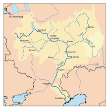
| Progression | Kama→ Volga→ Caspian Sea |
It is 1,430 kilometres (890 mi) long, and its drainage basin covers 142,000 square kilometres (55,000 sq mi).[1][2]
Settlements along the Belaya include Beloretsk, Sterlitamak, Ufa (at the confluence with the river Ufa), and Birsk. The Belaya flows into the Kama near Neftekamsk.
Tributaries
The largest tributaries of the Belaya are, from source to mouth:[1]
See also
References
- «Река БЕЛАЯ», Russian State Water Registry
- "Belaya River". Britannica.com. Retrieved 30 May 2016.
Gallery
 The middle Belaya valley
 The entrance to the Kapova Cave
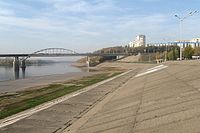 The Belaya River in Ufa


The river Kama | ||
|---|---|---|
Left tributary of the Volga | ||
| Tributaries |  | |
| Reservoirs | ||
| Hydroelectric stations |
| |
Authority control | |
|---|---|
| General |
|
| National libraries | |
This Bashkortostan location article is a stub. You can help Wikipedia by expanding it. |
This article related to a river in Russia is a stub. You can help Wikipedia by expanding it. |
На других языках
[de] Belaja
Die Belaja (russisch Бе́лая, baschkirisch Ағиҙел, tatarisch Агыйдел/Ağidel, udmurtisch Тӧдьы Кам (alle ungefähr „Weißer Fluss“), Mari Ош Виче („Weiße Wjatka“)) ist ein linker und mit 1430 km Länge der größte Nebenfluss der Kama im europäischen Teil Russlands.- [en] Belaya (Kama)
[es] Río Bélaya (Kama)
El río Bélaya, o también río Aghidhel (pronunciado [ˌʌɣiˈðel]; en ruso: Бе́лая; en baskir: Ағиҙел) es un río del este de la Rusia europea, el mayor afluente del río Kama. Su longitud es de 1430 km (10° río más largo de Europa) y drena una cuenca de 142 000 km².[it] Belaja (affluente della Kama)
La Belaja è un fiume della Russia europea orientale (Baschiria e Tatarstan), affluente di destra della Kama. È noto ai tatari con il nome di Ağidel (Агыйдел) e ai baschiri con quello di Aghidhel (Ағиҙел); questi nomi, in queste due lingue, significano "Volga bianco", mentre il suo nome russo significa semplicemente "bianca" (dato che la parola "fiume", in russo, è femminile).[ru] Белая (приток Камы)
Бе́лая (башк. Ағиҙел слушать,тат. Агыйдел) — река на Южном Урале и в Предуралье; левый и самый крупный приток Камы[2]. Протекает по территории Башкортостана и по его границе с Татарстаном[3]. Длина реки — 1430 км, площадь водосборного бассейна — 142 000 км²[4][5], самая длинная река в Башкортостане.Другой контент может иметь иную лицензию. Перед использованием материалов сайта WikiSort.org внимательно изучите правила лицензирования конкретных элементов наполнения сайта.
WikiSort.org - проект по пересортировке и дополнению контента Википедии