geo.wikisort.org - River
The Mulyanka (Russian: Муля́нка, pronounced [mʊˈlʲanka]), also referred as Upper Mulyanka, is a small river in Perm Krai, Russia which flows in the city of Perm and nearby Permsky District and is a left tributary of the Kama. The proximity of city's industry has a heavy influence on the river ecology.
| Mulyanka | |
|---|---|
 Mulyanka River location in Europe | |
 Location of mouth of Mulyanka River in Perm | |
| Location | |
| Country | Russia |
| Physical characteristics | |
| Source | |
| • location | Permsky District of Perm Krai |
| • coordinates | 57.7668°N 56.4002°E |
| Mouth | |
• location | Kama |
• coordinates | 58.0097°N 56.1373°E |
| Length | 52 km (32 mi) |
| Basin size | 460.7 km2 (177.9 sq mi) |
| Basin features | |
| Progression | Kama→ Volga→ Caspian Sea |
Geography


The Mulyanka is 52 kilometres (32 mi) long, and the area of its drainage basin is 460.7 square kilometres (177.9 sq mi). Mulyanka has 35 tributaries; the largest of them is its left tributary, Pyzh.[1] One of its right tributaries is the Malinovka.
The origin of Mulyanka is in the Permsky District of Perm Krai. It mainly flows along the west outskirts of the left-bank (relatively to Kama) part of Perm's (Industrialny and Dzerzhinsky city districts).
The village of Verkhniye Mully (Ве́рхние Муллы́), one of the oldest historical settlements in the borders of modern Perm, is situated at the banks of the Mulyanka. Since 1958 it belongs to Industrialny City District of Perm.[2]
There are following bridges over Mulyanka in Industrialny City District:
- Bridge at Leonov Street.
- Bridge at Promyshlennaya Street.
- Bridge at Cosmonauts Highway.
Then Mulyanka flows along the edge of Chernyayevsky Forest and crosses the borders of Industrialny and Dzerzhinsky City Districts. In Dzerzhinsky District it flows between Parkovy and Zaostrovka microdistricts and is crossed by following bridges:
- The pedestrian bridge.
 View from the bridge at Stroiteley Street
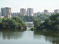 Close-up
 Entry to the bridge from the right bank

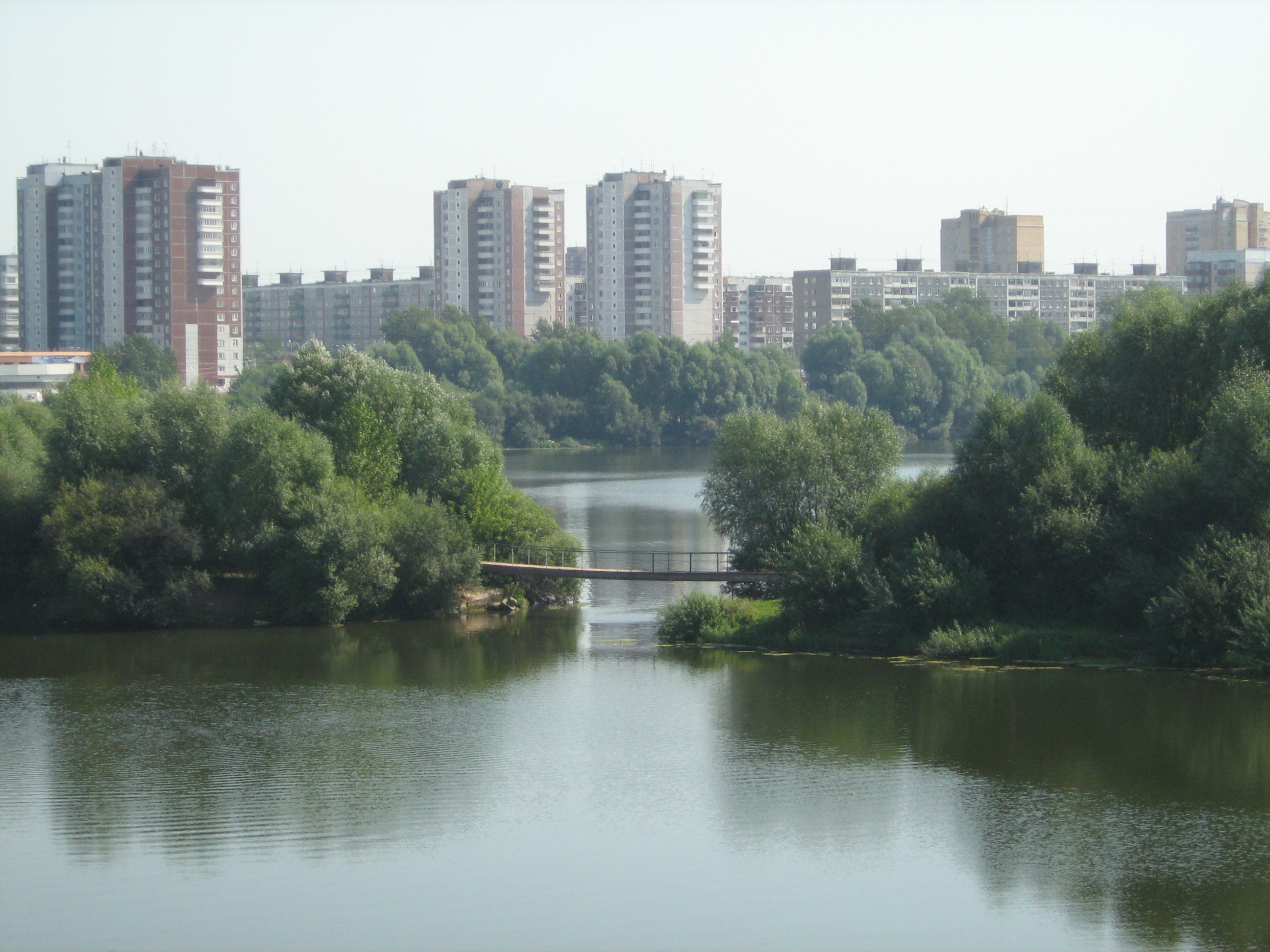

- The bridge at Stroiteley Street has been opened July 13, 2007. It connects Parkovy microdistrict with Krasavinsky bridge (over Kama River). It is 248 metres (814 ft) long. The construction of bridge began in 2005 and costs 796.26 million rubles.[3][4]
 Bridge construction, 2006
 View from the right bank

- The bridge at Krasin Street.
- The bridge at 1st Trudovaya Street is last. It is situated near the mouth of the Mulyanka.
The mouth of the Mulyanka is in the Zheleznodorozhny microdistrict of Dzerzhinsky City District of Perm. The width of the Mulyanka is frequently changing and in some places reaches 400 metres (1,300 ft).[5]
Ship transport
Mulyanka is not included in the list of navigable rivers of Perm Krai, which consists of Kama, Vishera, Sylva, and Chusovaya.[6]
History

Unlike most rivers of Perm Krai, whose toponymy is considered to be Permic, the names of rivers of Upper Mulyanka and Lower Mulyanka came from the Persian word "mullah". The researchers of history of Perm Krai connect it with Tatarian prince Mametkul, who settled in the region before or during the reign of Ivan the Terrible and was an imam, or mullah. His elder son, Urak-bey Mametkulov, lived at the Upper Mulyanka, and the younger son, Irak-bey Syundyuk-bey Mametkulov lived at the Lower Mulyanka. So came the names of this rivers and the villages Verkhniye Mully (meaning, 'The Upper Mullahs') and Nizhniye Mully ('The Lower Mullahs'), respectively. More old Pre-Turkic names of this rivers were lost.[7][8]
In 1722, Georg Wilhelm de Gennin, manager of Ural State Factories and master Cimmerman, took samples of copper ore from the banks of Mulyanka. The test results confirmed de Gennin's intention to start the construction of Yegoshikha copper smelting factory which resulted in the foundation of Perm city.[9]
Ecology

Mulyanka runs along the borders of the city of Perm and is contaminated by industrial waste, such at that of stock-breeding farms and sawmills. Mulyanka is influenced by the adjacency of oil refinery of Lukoil-Permnefteorgsintez which was put into operation in 1958.[citation needed]
Chemical composition
According to a 2004 report by the Perm Oblast's Administration of Environment Protection, water in the Mulyanka River belongs to the 2nd to 3rd class of quality, but the upper waters, taking into account nitrites, iron and oxygen content, belong to the 4th class. This makes it unsuitable for drinking and fish farming even after preliminary processing. The oxygen mode in the river is found to be unfavorable. The chemical consumption of oxygen amounts to 40–70 mg/L while the norm is 30 mg/L; the biochemical consumption is 5.15–7.08 mg/L, while norm is 5 mg/L. The concentration of suspended substances is 11–18 mg/L.[10]
Condition of zoobenthos
According to the results of research, performed by experts of Perm State University, the pollution of Mulyanka exercises strong negative influence on the condition of zoobenthos.[1] Middle and lower parts of river are the most polluted ones. The biggest source of pollution is Lukoil Permneft Ltd, whose waste reaches Mulyanka by the Pyzh River. The oil products content of Mulyanka water at the place of the Pyzh's confluence exceeds the Maximum Permissible Concentration 49.4 times. Close to the mouth of Mulyanka ammonium content exceeds the MPC 1.3 times, 2.5 times for nitrites and 2 times for the oil products. As a result of bottom fauna sample analysis, 75 species have been discovered: ten species of Oligochaeta, two species of Hirudinea, six species of Gastropoda, two species of Bivalvia, and 55 species of Insecta. The distribution of macrozoobenthos in different sectors of the river is:
| River sector | Number of species | Biomass, g/m² | Quantity, thousands of specimens per m² |
|---|---|---|---|
| High | 53 | 57,9 | 4,8 |
| Middle | 23 | 11,8 | 1,2 |
| Lower | 24 | 4,8 |
Research by young ecologists
In 2003, a group of young ecologists from the School #6 of Perm city and the School of Kultayevo Village performed an investigation of the ecological condition of water in the Mulyanka River within the project titled Ecological condition of small rivers of Perm City and suburb zone. The samples of water were taken close to Kultayevo Village and near the river mouth in Parkovy microdistrict. The chemical analysis of water was performed in the Ecological Laboratory of Chemistry chair in the Perm State Pedagogical University. The research showed that chemical composition of Mulyanka water was different inside and outside the city. The data obtained demonstrated that "the water in the Mulyanka river isn't suitable for drinking".[11]
In 2005, pupils from the School #59 of Perm City took part in the DOOG—2005 "Remote Educational Contest in Geography" and performed an experiment entitled “Purification of water from the Mulyanka River”.[12] The results are presented in the table:
| Water | Before purification | After the settling | After the filtration through the sand | After the absorption with coal |
|---|---|---|---|---|
| Smell | light smell of slime | no | This stage of purification wasn't performed because the Mulyanka water sample happened to be clean enough. | no |
| Transparency | turbid | slightly turbid | transparent | |
| Colour | light yellow hue | light-coloured | light-coloured | |
| Presence of oil drops | no | no | no | |
| Presence of solid particles | no | no | no | |
| Water volume | 100 mL | 96 mL | 85 mL |
As a result of the experiment, the conclusion was made: "water, taken from the Mulyanka River, may be purified by settling, filtration and absorption". This work was rewarded the Second degree DOOG-2005 diploma.[13]
External links
References
- (in Russian) М. С. Алексевнина, Е. В. Преснова Состояние бентофауны реки Мулянки (бассейн Камы) в условиях антропогенной нагрузки. / Экосистемы малых рек: биоразнообразие, экология, охрана. Тезисы докладов II Всероссийской конференции. Борок, 16—19 ноября 2004 г. (PDF Archived 2007-09-28 at the Wayback Machine) — Институт биологии внутренних вод им. И. Д. Папанина.
- (in Russian) Verkhniye Mully (Perm Region Encyclopedia) Archived 2008-02-17 at the Wayback Machine
- (in Russian) В Перми состоялось торжественное открытие автодороги по улице Строителей. Archived 2007-10-11 at the Wayback Machine // Российское информационное агентство «Новый Регион».
- (in Russian) Строительство моста через реку Мулянку в Перми завершится в 2006 году. Archived 2007-10-08 at the Wayback Machine // Российское информационное агентство «Новый Регион».
- (in Russian) Пермь. План города. // ФГУП «Уралаэрогеодезия», 2006 г.
- (in Russian) Transport infrastructure of modern Perm Region (Perm Region Encyclopedia). Archived 2008-02-20 at the Wayback Machine
- (in Russian) Д. Б. Рамазанова. К истории формирования говора пермских татар. (On the genesis of the Perm Tatar dialect)
- (in Russian) З. А. Мухаева. Топонимия территории пермского говора татарского языка (юга Пермской области). (Toponimics of the lands where the Perm Tatar dialect is spoken (the southern part of the Perm Oblast)
- (in Russian) Основание Егошихинского завода. Archived 2005-02-04 at the Wayback Machine
- (in Russian) Состояние водных объектов Пермской области. Archived 2010-01-12 at the Wayback Machine / Доклад Управления по охране окружающей среды Пермской области "Cостояние и охрана окружающей среды в Пермской области" за 2004 год.
- (in Russian) Е. Н. Никулина, В. К. Суверева, В. В. Мисенжников. Организация гидрохимических исследований малых рек в рамках школьного экологического мониторинга. Archived 2007-03-10 at the Wayback Machine / Материалы областной научно-практической конференции «Экологическая культура населения — фактор устойчивого развития».
- (in Russian) Отчёт команды АЙСБЕРГ, ID 013 о выполнении практического тура. Archived 2007-03-10 at the Wayback Machine
- (in Russian) Remote Educational Contest in Geography — 2005: Results
The river Kama | ||
|---|---|---|
Left tributary of the Volga | ||
| Tributaries |  | |
| Reservoirs | ||
| Hydroelectric stations |
| |
На других языках
[de] Muljanka
Die Muljanka (russisch Мулянка), auch als "Obere Muljanka" bekannt, ist ein 52 km langer linker Nebenfluss der Kama im europäischen Teil Russlands. Er fließt durch Perm und die umliegende Region Perm. Die Nähe der Stadtindustrie hat einen großen Einfluss auf die Flussökologie.- [en] Mulyanka
[es] Río Mulianka
El Mulianka (en ruso: Муля́нка) es un río pequeño en Rusia, un tributario izquierdo del río Kama. Atraviesa la ciudad de Perm. La proximidad de la industria de la ciudad tiene una influencia pesada en la ecología del río.[it] Muljanka
Il fiume Muljanka (in russo Мулянка) è un affluente di sinistra del Kama, nel Territorio di Perm' nella Russia europea.[ru] Мулянка (река, впадает в Воткинское водохранилище)
Муля́нка (в верховье Верхняя Мулянка) — малая река в Перми и Пермском районе Пермского края. Устье реки находится на 672 км от устья по левому берегу Воткинского водохранилища Камы. Длина реки — 52 км, площадь бассейна — 467 км².[2] Высота устья — 89 м над уровнем моря.[источник не указан 297 дней]Другой контент может иметь иную лицензию. Перед использованием материалов сайта WikiSort.org внимательно изучите правила лицензирования конкретных элементов наполнения сайта.
WikiSort.org - проект по пересортировке и дополнению контента Википедии