geo.wikisort.org - River
Arghandab is a river in Afghanistan, about 400 km (250 mi) in length. It rises in Ghazni Province, west of the city of Ghazni, and flows southwest passing near the city of Kandahar, and then joins the Helmand River 30 km (19 mi) below Grishk. In its lower course, it is much used for irrigation, under the control of the Helmand and Arghandab Valley Authority, and the valley is cultivated and populous; yet the water is said to be somewhat brackish. It is doubtful whether the ancient Arachotus is to be identified with the Arghandab or with its chief confluent the Tarnak, which joins it on the left 50 km (31 mi) southwest of Kandahar.[2] The Tarnak, which flows south of Kandahar, is much shorter (length about 320 km or 200 miles) and less copious.
| Arghandab River Sanzari wala,Arghandab wala, Arghandab sind,ارغنداب رود | |
|---|---|
 | |
 Mouth of the Arghandar River in Afghanistan | |
| Native name | Arghandaw rod (Pashto) |
| Location | |
| Country | Afghanistan |
| Cities | Kandahar Lashkargah |
| Physical characteristics | |
| Source | |
| • location | North of Sang-e-Masha[1] |
| • coordinates | 33.436630°N 67.516588°E |
| Mouth | |
• location | Lashkargah[1] |
• coordinates | 31.432381°N 64.383568°E |
| Length | 400 km (250 mi) |
Historical background
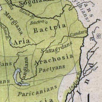
The river was known to the ancient Iranians as Haraxvaiti in Avestan and Harahuvati in Old Persian, which are cognate with Rigvedic Sarasvati (as described in its "family books"). Scholars such as Boyce and Parpola have identified Greek Arachosia as a Hellenization of the name, meaning the land of Haraxvaiti.[3][4] Rigveda's hymn VI.61.2 describes it with the words:
By means of her gushing and powerful waves, this (Sarasvatī) has crushed the ridge of the mountains, (breaking river banks) like a man who digs for lotus roots; with praises and prayers, we solicit Sarasvatī for her help, (Sarasvatī) who slays the foreigners.[5]
Historian Asko Parpola states: "Arghandab [...] descends from a height of nearly four kilometers down to about 700 meters when it joins the Helmand River, which eventually forms shallow lakes." Sarasvatī- is interpreted to mean "full of lakes".[5]
Some historians, however, assert that the Avestan Haraxvaiti as well as the Rigvedic Sarasvati refer to the Helmand River. The Rigvedic name of Arghandab is then believed to be Drishadvati.[lower-alpha 1]
The ruins at Ulan Robat, supposed to represent the city Arachosia, are in its basin; and the lake known as Ab-i Istada, the most probable representative of Lake Arachotus, is near the head of the Tarnak, though not communicating with it. The Tarnak is dammed for irrigation at intervals, and in the hot season almost dries up.[2]
Upper course

This section needs expansion. You can help by adding to it. (April 2018) |
The upper course of the Arghandab river is relatively unexplored. The Historical and Political Gazetteer of Afghanistan cites the explorations of Major G. Lynch in 1841,[lower-alpha 2] according to whom the origin of the Arghandab is 20 to 30 miles north of Sang-e-Masha. This places the source in the mountains southwest of the Nawar basin. Lynch also described the upper course of the river as being a "mountain torrent, dashing over great granite rocks and about 3 feet deep where fordable".[1]
Lower course
There is a good deal of cultivation along the river, but few villages. The Kabul-Kandahar Highway passes this way (another reason for supposing the Tarnak to be Arachotus), and the people live off the road to avoid the onerous duties of hospitality.[2]
Dahla dam
In 2008 a project was initiated to rehabilitate the Dahla Dam and associated irrigation system.[10][11][12][13][14][15]
See also
Notes
-
- Ram Sharan Sharma: "In the Ṛg Veda, the Sarasvati is called the best of the rivers (naditama). It seems to have been a great river with perennial water... The earliest Sarasvati is considered identical with the Helmand in Afghanistan which is called Harakhwati in the Avesta. But the archaeology of the Helmand valley in the second millennium BC needs adequate attention."[6]
- Rajesh Kocchar: "The Avestan Harahvaiti, phonetically the same as Sarasvati, was known to the Greeks as Etymander and is now called Arghandab. The naditama Sarasvati, however, is to be equated not with the Arghandab but with the Helmand, of which the Arghandab is the main tributary. ... There is an uncanny similarity between the Rgvedic description of Sarasvati and Avestan description of the Helmand."[7]
- Possibly the British political agent Kalat-i-Ghilzai.[8][9]
References
- Adamec, Historical and Political Gazetteer of Afghanistan, Vol. 5 1980, p. 39.
- One or more of the preceding sentences incorporates text from a publication now in the public domain: Chisholm, Hugh, ed. (1911). "Arghandab". Encyclopædia Britannica. Vol. 2 (11th ed.). Cambridge University Press. p. 475.
- Parpola, The Roots of Hinduism 2015, Ch. 6, p. 97.
- Boyce, Mary; Grenet, Frantz (1991). A history of Zoroastrianism. Vol. III, Zoroastrianism under Macedonian and Roman rule. Leiden: Brill. p. 125. ISBN 9004092714.
- Parpola, The Roots of Hinduism 2015, Chapter 6.
- Sharma, Ram Sharan (1999), Advent of the Aryans in India, Manohar Publishers & Distributors, pp. 35–36, ISBN 978-81-7304-263-8
- Kochhar, Rajesh (1999), "On the identity and chronology of the Ṛgvedic river Sarasvatī", in Roger Blench; Matthew Spriggs (eds.), Archaeology and Language III; Artefacts, languages and texts, Routledge, pp. 262–263, ISBN 0-415-10054-2
- Buist, George (1843), Outline of the Operations of the British Troops in Scinde and Afghanistan: Betwixt Nov. 1838 and Nov. 1841; with Remarks on the Policy of the War, Times Office, pp. 272–
- J. W. Fortescue, History of the British Army, Volume XII: 1839–1852, Macmillan and Co, 1927
- "Provincial profile for Kandahar Province" (PDF). Regional Rural Economic Regeneration Strategies. Archived from the original (PDF) on 2008-08-28. Retrieved 2008-10-07.
- Stephen Chase (2008-07-17). "Dahla dam project is potential target: military". The Globe and Mail. Retrieved 2008-10-07.
- Doug Schmidt (2008-06-11). "Cdn. military to safeguard Afghan dam project". Canwest News Service. Retrieved 2008-10-07.
- "Signature Project: Dahla Dam and Irrigation System". Government of Canada. Archived from the original on 2013-01-01. Retrieved 2008-10-07.
- "Dahla Dam -- Summer 2008 (video podcast)". Government of Canada. Archived from the original on 2011-07-06. Retrieved 2008-10-07.
- "Dahla Dam -- Summer 2008". Government of Canada. Retrieved 2008-10-07.[permanent dead link]
Bibliography
- Adamec, Ludwig W., ed. (1980), Historical and Political Gazetteer of Afghanistan, Vol. 5 (PDF), Akademische Druck- u. Verlagsanstalt, ISBN 978-3-201-01125-9
- Parpola, Asko (2015), The Roots of Hinduism: The Early Aryans and the Indus Civilization, Oxford University Press Incorporated, ISBN 978-0190226923
External links
- Distance Learning Module 3 - Rivers of the Hindu Kush, Pamir, and Hindu Raj, the University of Nebraska, Center for Afghanistan Studies, Retrieved 15 April 2018.
Capital: Ghazni | ||
| Districts |  | |
| Populated places |
| |
| Landforms | ||
| Other |
| |
Capital: Kandahar | ||
| Districts |  | |
| Populated places |
| |
| Landforms | ||
| Other |
| |
Authority control | |
|---|---|
| General |
|
| National libraries | |
На других языках
[de] Arghandāb
Der Arghandāb ist ein ca. 400 km langer Fluss in der Helmand-Provinz im Süden Afghanistans.- [en] Arghandab River
[it] Arghandab
L'Argandāb o Arghandāb Rōd[2] è un fiume dell'Afghanistan, lungo 400 km. Nasce nell'Hazarajat, presso la città di Ghazni, e scorre in direzione sud-ovest fino a confluire nel fiume Helmand, di cui è il maggior affluente, presso Lashkar Gah, 30 km a valle di Girishk.[ru] Аргандаб
Арганда́б[1] (перс. رود ارغنداب; в верховье Сайдахмад[2]) — река в центральной части Афганистана[3]. Левый и самый крупный приток реки Гильменд[4][5].Другой контент может иметь иную лицензию. Перед использованием материалов сайта WikiSort.org внимательно изучите правила лицензирования конкретных элементов наполнения сайта.
WikiSort.org - проект по пересортировке и дополнению контента Википедии