geo.wikisort.org - Fluss
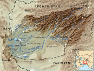
Der Arghandāb ist ein ca. 400 km langer Fluss in der Helmand-Provinz im Süden Afghanistans.
| Arghandāb | ||
 Verlauf des Arghandāb | ||
| Daten | ||
| Lage | Provinzen Helmand, Zabul, Kandahar, Ghazni (Afghanistan) | |
| Flusssystem | Hilmend | |
| Quelle | Kūh-e Ṣafīd in der Provinz Ghazni 32° 46′ 48″ N, 66° 54′ 36″ O | |
| Quellhöhe | ca. 3900 m | |
| Mündung | südlich der Provinzhauptstadt Laschkar Gah in den Hilmend 31° 26′ 37″ N, 64° 22′ 59″ O | |
| Mündungshöhe | 749 m | |
| Höhenunterschied | ca. 3151 m | |
| Sohlgefälle | ca. 7,9 ‰ | |
| Länge | ca. 400 km | |
| Einzugsgebiet | 52.920 km²[1] | |
| Abfluss am Pegel 44 km oberhalb der Dahla-Talsperre[1] AEo: 11.525 km² |
MQ 1951/1979 Mq 1951/1979 |
41,6 m³/s 3,6 l/(s km²) |
| Abfluss am Pegel 3,5 km unterhalb der Dahla-Talsperre[1] AEo: 12.975 km² |
MQ 1947/1979 Mq 1947/1979 |
39,2 m³/s 3 l/(s km²) |
| Abfluss am Pegel Qala-i-Bust[1] AEo: 52.920 km² |
MQ 1947/1980 Mq 1947/1980 |
28,2 m³/s 0,5 l/(s km²) |
| Linke Nebenflüsse | Dori | |
| Durchflossene Stauseen | Dahla-Talsperre | |
| Großstädte | Kandahar | |
 Das Mausoleum des Baba Wali, das im Flusstal des Arghandāb liegt. | ||
 Dahla-Talsperre | ||
Obwohl das Einzugsgebiet des Arghandāb fruchtbar ist, ist es relativ dünn besiedelt. Der Arghandāb ist der größte Nebenfluss des Hilmend. Am Flusslauf liegen die Dahla-Talsperre sowie die Großstadt Kandahar.
Hydrometrie
Mittlerer monatlicher Abfluss des Arghandāb (in m³/s) am Pegel Qala-i-Bust (6 km oberhalb der Mündung in den Hilmend)
gemessen von 1947 bis 1980[1]

Weblinks
Commons: Arghandāb – Sammlung von Bildern, Videos und Audiodateien
- Arghandāb. In: Ehsan Yarshater (Hrsg.): Encyclopædia Iranica. (englisch, iranicaonline.org – inkl. Literaturangaben).
Einzelnachweise
- Tara Williams-Sether: Streamflow Characteristics of Streams in the Helmand Basin, Afghanistan (PDF 5,31 MB) USGS.
На других языках
- [de] Arghandāb
[en] Arghandab River
Arghandab is a river in Afghanistan, about 400 km (250 mi) in length. It rises in Ghazni Province, west of the city of Ghazni, and flows southwest passing near the city of Kandahar, and then joins the Helmand River 30 km (19 mi) below Grishk. In its lower course, it is much used for irrigation, under the control of the Helmand and Arghandab Valley Authority, and the valley is cultivated and populous; yet the water is said to be somewhat brackish. It is doubtful whether the ancient Arachotus is to be identified with the Arghandab or with its chief confluent the Tarnak, which joins it on the left 50 km (31 mi) southwest of Kandahar.[2] The Tarnak, which flows south of Kandahar, is much shorter (length about 320 km or 200 miles) and less copious.[it] Arghandab
L'Argandāb o Arghandāb Rōd[2] è un fiume dell'Afghanistan, lungo 400 km. Nasce nell'Hazarajat, presso la città di Ghazni, e scorre in direzione sud-ovest fino a confluire nel fiume Helmand, di cui è il maggior affluente, presso Lashkar Gah, 30 km a valle di Girishk.[ru] Аргандаб
Арганда́б[1] (перс. رود ارغنداب; в верховье Сайдахмад[2]) — река в центральной части Афганистана[3]. Левый и самый крупный приток реки Гильменд[4][5].Текст в блоке "Читать" взят с сайта "Википедия" и доступен по лицензии Creative Commons Attribution-ShareAlike; в отдельных случаях могут действовать дополнительные условия.
Другой контент может иметь иную лицензию. Перед использованием материалов сайта WikiSort.org внимательно изучите правила лицензирования конкретных элементов наполнения сайта.
Другой контент может иметь иную лицензию. Перед использованием материалов сайта WikiSort.org внимательно изучите правила лицензирования конкретных элементов наполнения сайта.
2019-2026
WikiSort.org - проект по пересортировке и дополнению контента Википедии
WikiSort.org - проект по пересортировке и дополнению контента Википедии