geo.wikisort.org - Reservoir
Lake Zurich (Swiss German/Alemannic: Zürisee; German: Zürichsee; Romansh: Lai da Turitg)[1] is a lake in Switzerland, extending southeast of the city of Zürich. Depending on the context, Lake Zurich or Zürichsee can be used to describe the lake as a whole, or just that part of the lake downstream of the Seedamm at Rapperswil, whilst the part upstream of Rapperswil may be called the Obersee or Upper Lake.
| Lake Zurich | |
|---|---|
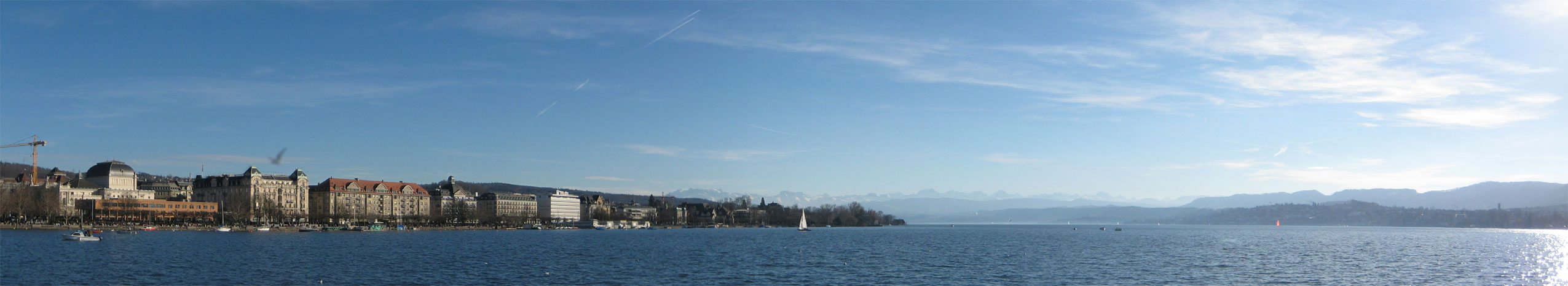
 Lake Zürich, Pfannenstiel and Sihl Valley, as seen from nearby Felsenegg (April 2010) | |
Lake Zurich Lake Zurich Lake Zurich  Lake Zurich  Lake Zurich | |
 | |
| Coordinates | 47°14′51″N 8°40′39″E |
| Native name | Zürichsee (German) |
| Primary inflows | Linth (Linthkanal) |
| Primary outflows | Limmat |
| Catchment area | 1,829 km2 (706 sq mi) |
| Basin countries | Switzerland |
| Max. length | 40 kilometres (25 miles) |
| Max. width | 3 kilometres (2 miles) |
| Surface area | 88.66 square kilometres (34.23 square miles) |
| Average depth | 49 metres (161 feet) |
| Max. depth | 136 metres (446 feet) |
| Water volume | 3.9 km3 (0.94 cu mi) |
| Residence time | 440 days |
| Surface elevation | 406 m (1,332 ft) |
| Frozen | 1929, 1962/1963 (last) |
| Islands | Lützelau, Ufenau, Schönenwirt |
| Sections/sub-basins | Obersee |
| Settlements | see list |
 | |
Geography
Lake Zurich is formed by the Linth river, which rises in the glaciers of the Glarus Alps and was diverted by the Escher canal (completed in 1811) into Lake Walen from where its waters are carried to the east end of Lake Zurich by means of the Linth canal (completed in 1816). The waters of the Lake of Zurich flow out of the lake at its north-west end (Quaibrücke), passing through the city of Zürich; however, the outflow is then called the Limmat.[2] The culminating point of the lake's drainage basin is the Tödi at 3,614 metres above sea level.[3]
No streams of importance flow into the lake besides the Linth.[2] The Seedamm, a partially artificial causeway and bridge, crosses a narrow point of the lake carrying a railway line and road from Rapperswil to Pfäffikon. The eastern section of the lake is known as the Obersee ("upper lake"). West of this dam lie the small islands of Lützelau and Ufenau, where in 1523 Ulrich von Hutten took refuge and died. Both shores are well cultivated and fertile.[2] Another tourist destination is the Au peninsula at the village of Au between Wädenswil and Horgen.
To the east – separated by Zürichberg-Adlisberg, Forch and Pfannenstiel – are two minor lakes: Greifensee (Lake Greifen) and Pfäffikersee (Lake Pfäffikon). Zimmerberg and the Etzel regions lie to the west.
Administratively, Lake Zurich is split between the cantons of Zürich, St. Gallen and Schwyz. The lower lake, to the west of the Seedamm, is largely in the canton of Zürich, whilst the upper lake is shared between the cantons of St. Gallen and Schwyz.
History
The lake was frozen in the following years
- 1223, 1259, 1262
- 1407, 1491
- 1514, 1517, 1573
- 1600, 1660, 1684, 1695
- 1709, 1716, 1718, 1740, 1755, 1763, 1789
- 1830, 1880, 1891, 1895
- 1929, 1963
Population and transportation
The three population and transportation centres are Zurich, Pfäffikon SZ and Rapperswil.
Besides Quaibrücke in Zurich and the Seedamm, there are no bridges across the lake.
The Zürichsee-Schifffahrtsgesellschaft – the Lake Zurich Navigation Company – provides with its 17-passenger ships touristic services on Lake Zurich. There are a number of passenger ferry services, noticeably the Horgen–Meilen ferry, an auto ferry between Horgen and Meilen.
Towns on the lake
Zürich, at the north-western end of the lake, is the largest city on Lake Zurich.
On the west shore (which gradually becomes the south shore) are Rüschlikon, Thalwil, Horgen, Wädenswil, Richterswil, Pfäffikon, and Lachen.
On the opposite shore are Küsnacht, Meilen, Stäfa, and Rapperswil-Jona with the medieval town of Rapperswil, whose castle is home to the Polish museum. Schmerikon is close to the east end of the lake, and a little further east is the larger town of Uznach.

Water quality
Lake Zurich's water is very clean and reaches, during summer, temperatures well beyond 20 °C (68 °F). Swimming in the public baths and beaches is very popular. The lake's water is purified and fed into Zürich's water system; it is potable.
Prehistoric pile dwellings around Zürichsee
The Prehistoric pile dwellings around Zürichsee comprises 11 of total 56 Prehistoric pile dwellings around the Alps in Switzerland, that are located around Zürichsee in the cantons of Schwyz, St. Gallen and Zürich.[4][5]
Located on Zürichsee lakeshore, there are Freienbach–Hurden Rosshorn, Freienbach–Hurden Seefeld, Rapperswil-Jona/Hombrechtikon–Feldbach, Rapperswil-Jona–Technikum, Erlenbach–Winkel, Meilen–Rorenhaab, Wädenswil–Vorder Au, Zürich–Enge Alpenquai, Grosser Hafner and Kleiner Hafner. Because the lake has grown in size over time, the original piles are now around 4 metres (13 ft) to 7 metres (23 ft) under the water level of 406 metres (1,332 ft). Also on the small area of about 40 square kilometres (15 sq mi) around Zürichsee are the settlements Greifensee–Storen/Wildsberg on Greifensee and Wetzikon–Robenhausen on Pfäffikersee lakeshore.
As well as being part of the 56 Swiss sites of the UNESCO World Heritage Site, each of these 11 prehistoric pile dwellings is also listed as a Class object in the Swiss inventory of cultural property of national and regional significance.[6]
Tributaries
The following rivers or streams flow into Zürichsee.[7] From the Limmat clockwise, they are:

- Hornbach (at Zürichhorn)
- Düggelbach (at Zollikon)
- Kusenbach (at Küsnacht)
- Küsnachter Dorfbach (at Hornelanpark, Küsnacht)
- Heslibach (at Erlenbach)
- Dorfbach Erlenbach (at Erlenbach)
- Tobelbächli (at Erlenbach)
- Schipfbach (at Erlenbach)
- Rossbach (at Herrliberg)
- Meilener Dorfbach (at Meilen)
- Beugenbach (at Meilen)
- Aebletenbach (at Ländeli)
- Uetiker Mulibach (at Meilen)
- Feldbach (at Horn)
- Sarenbach (at Freienbach)
- Krebsbach (at Bäch)
- Mülibach (at Richterswil)
- Zürichsee (at Wädenswil)
- Meilibach (at Wädenswil)
- Schanzengraben (Zürich)
Gallery
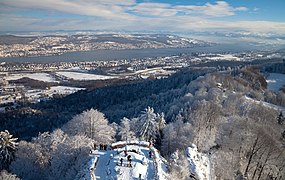 View from the top of the observation tower at Uetliberg.
 View from Felsenegg to the eastern part of Lake Zürich
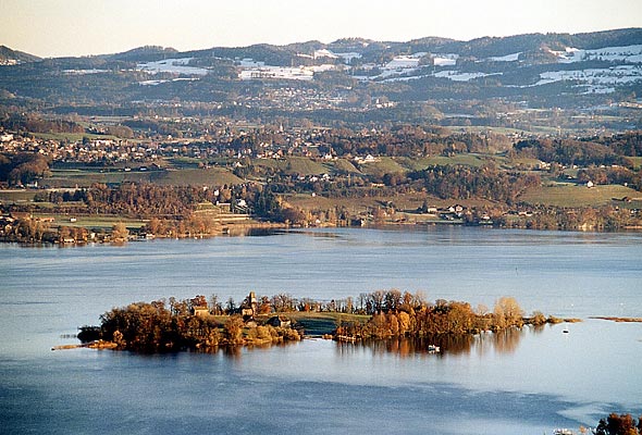
 Ufenau island
 Au peninsula
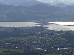 Seedamm between Rapperswil and Hurden, view from Bachtel hill
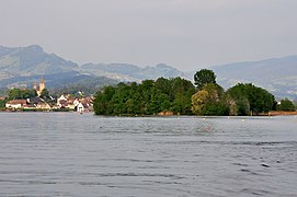 Lützelau and Rapperswil, view from Ufenau island
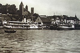 Paddle steamships Stadt Rapperswil (to the left) and Stadt Zürich (1914) at Rapperswil (SG) harbour
 Zurisee from an airplane


See also
- Obersee (Zürichsee)
- Prehistoric pile dwellings around Zürichsee
- Paddle steamer Stadt Rapperswil
- Paddle steamer Stadt Zürich
- Radio Zürisee
- Seedamm
- Zürichsee-Zeitung
References
- "National Map 1:50 000" (Map). Zürichsee (2011 ed.). 1:50 000. "National Map 1:50'000, 78 sheets and 25 composites". Bern, Switzerland: Swiss Federal Office of Topography, swisstopo. 16 January 2014. § "5011 Zürichsee - Zug". ISBN 978-3-302-05011-9. Retrieved 2014-12-01.
- One or more of the preceding sentences incorporates text from a publication now in the public domain: Coolidge, William Augustus Brevoort (1911). "Zürich, Lake of". In Chisholm, Hugh (ed.). Encyclopædia Britannica. Vol. 28 (11th ed.). Cambridge University Press.
- "National Map 1:25 000" (Map). Tödi, Lake Zurich's culmination point (2009 ed.). 1:25 000. "National Map 1:25'000, 247 sheets and 17 composites". Bern, Switzerland: Swiss Federal Office of Topography, swisstopo. 16 January 2014. § "1193 Tödi". ISBN 978-3-302-05011-9. Retrieved 2014-12-01.
- "Prehistoric Pile Dwellings in Switzerland". Swiss Coordination Group UNESCO Palafittes (palafittes.org). Archived from the original on 2014-10-07. Retrieved 2014-12-07.
- "World Heritage". palafittes.org. Archived from the original on 2014-12-09. Retrieved 2014-12-10.
- "A-Objekte KGS-Inventar". Schweizerische Eidgenossenschaft, Amt für Bevölkerungsschutz. 2009. Archived from the original on 2010-06-28. Retrieved 2014-12-10.
- Bradshaw's pedestrian route-book for Switzerland, Chamouni, and the Italian lakes, George Bradshaw (1868)
External links
- Peter Ziegler: Zürichsee in German, French and Italian in the online Historical Dictionary of Switzerland, 28 February 2014.
- Zürichsee Schifffahrtsgesellschaft—Boat schedules, mainly non-English.
- Zürichsee-Fähre Horgen-Meilen—Ferry schedules, in German.
- Waterlevels Lake Zürich at Zürich
- Lake Zurich ENC Chart
| |||||
| Settlements |
|   | |||
| Islands | |||||
| Rivers | |||||
| Valleys |
| ||||
| Mountains | |||||
| Landmarks | |||||
| Transportation |
| ||||
| People |
| ||||
Prehistoric pile dwellings in Switzerland | ||
|---|---|---|
| Espace Mittelland |
|  |
| Nationwide |
| |
| ||
Lakes of Switzerland | ||
|---|---|---|
| Major lakes |
|  |
| Lists | ||
Authority control | |
|---|---|
| General |
|
| National libraries | |
| Other |
|
На других языках
[de] Zürichsee
Der Zürichsee (zürichdeutsch Zürisee [.mw-parser-output .IPA a{text-decoration:none}ˈt͡syɾiˌz̥eː]) ist ein See in der Schweiz. Er liegt südöstlich von Zürich in den Kantonen Zürich, St. Gallen und Schwyz.- [en] Lake Zurich
[es] Lago de Zúrich
El lago de Zúrich (en alemán, Zürichsee) es un lago de Suiza, que se extiende al sudeste de la ciudad de Zúrich. Los zuriqueses lo suelen denominar en alemán suizo Zürisee.[fr] Lac de Zurich
Le lac de Zurich (en allemand Zürichsee) est un lac suisse qui se trouve au sud-est de la ville de Zurich. Il est bordé par les cantons de Zurich, Schwytz et de Saint-Gall.[it] Lago di Zurigo
Il lago di Zurigo (Zürisee in svizzero tedesco, Zürichsee in tedesco) è un lago morenico della Svizzera che si estende a sudest della città di Zurigo. Geograficamente il lago di Zurigo si trova quasi completamente nel Canton Zurigo salvo la parte più meridionale, a cavallo tra i cantoni San Gallo e Svitto. Nelle vicinanze ci sono altri due piccoli laghi, il Greifen e il Pfäffikon, entrambi situati ad est del lago di Zurigo.[ru] Цюрихское озеро
Цю́рихское о́зеро (нем. Zürichsee, фр. Lac de Zurich) — озеро, расположенное в Швейцарии, на высоте 409 метров над уровнем моря между кантонами Санкт-Галлен, Швиц и Цюрих; площадь 88 км², наибольшая длина 40 км, ширина от 1 до 4 км, имеет серпообразную форму; на восточном конце принимает в себя реку Линт, вытекающую из западного края озера, в районе города Цюрих под именем реки Лиммат. Объём воды — 3,363 км³, площадь водного зеркала — 65,06 км², высота над уровнем моря — 406 метров[1].Другой контент может иметь иную лицензию. Перед использованием материалов сайта WikiSort.org внимательно изучите правила лицензирования конкретных элементов наполнения сайта.
WikiSort.org - проект по пересортировке и дополнению контента Википедии