geo.wikisort.org - Mountains
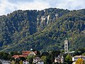
The Albis is a chain of hills in the Canton of Zürich, Switzerland, stretching for some 19 km from Sihlbrugg in the south to Waldegg near Zürich in the north. The chain forms, among others, the border between the Affoltern and Horgen districts. The best known point is Uetliberg at 870 m, overlooking the city of Zürich. Other points of interest include the Albishorn (909m.) the Bürglen (also known as Bürglenstutz, the highest peak, 914.6m.), the Schnabelburg, an observation tower, the Albis Pass, the small town of Buechenegg, and the extensive woods (known as the Sihlwald forest) on both sides of the river Sihl. The Sihl Valley borders the Albis chain on its entire east side. On the west side, the Albis is bordered by various streams (including the Reppisch) and one lake, the Türlersee.
This article does not cite any sources. (January 2009) |
| Albis | |
|---|---|
 The Albis chain as seen from the Uetliberg, looking southeast. In the background left the Glärnisch. | |
| Highest point | |
| Elevation | 914.6 m (3,001 ft) |
| Isolation | 11 km (6.8 mi) |
| Coordinates | 47°17′N 8°30′E |
| Geography | |
 Albis | |
| Country | Switzerland |
| Canton | Zürich |
The chain is mostly wooded, but also has extensive fields, often reaching to the summit, some cultivated, some used as pastures for cows or sheep. Being very near Zürich, the area is heavily visited, especially near its northern end, and includes many restaurants along the summit (from Uetliberg to Albishorn), well-maintained trails and dirt roads, a railroad (the Uetlibergbahn) from Zürich, and a cable car (Felseneggbahn) from Adliswil to Felsenegg.
The Albis chain was formed as the left moraine of the glacier the bed of which is now Lake Zürich. The soil is mostly a conglomerate of gravel, some of it large, and glacial loess. The frequently steep sides of the chain are often subject to small landslides. As a generalization, the eastern side of the chain (overlooking Lake Zürich) tends to be steeper than the western side.
The hilltops of the Albis provided several good defensive sites, and were the locations of the castles of Uetliberg, Baldern and Schnabelburg, all of which are now ruined or lost.
Picture gallery

 So called Fallätsche at Zürich-Leimbach, Wollishofen quarter in the foreground.
 Leimbach (Zürich), lower Sihltal and Albis hills, as seen from Käferberg
 360° panorama from Albis Hochwacht


| Wikimedia Commons has media related to Albis. |
| |||||
| Settlements |
|   | |||
| Islands | |||||
| Rivers | |||||
| Valleys |
| ||||
| Mountains | |||||
| Landmarks | |||||
| Transportation |
| ||||
| People |
| ||||
| Authority control |
|
|---|
На других языках
[de] Albis
Der Albis ist eine Bergkette im Kanton Zürich, die von Sihlbrugg im Süden bis Urdorf/Schlieren bei Zürich im Norden über etwa 22 Kilometer parallel zu Sihl und Zürichsee verläuft.- [en] Albis
Другой контент может иметь иную лицензию. Перед использованием материалов сайта WikiSort.org внимательно изучите правила лицензирования конкретных элементов наполнения сайта.
WikiSort.org - проект по пересортировке и дополнению контента Википедии