geo.wikisort.org - Reservoir
Lake Geneva (French: le Léman [lə lemɑ̃] or lac Léman [lak lemɑ̃], German: Genfersee [ˈɡɛnfərˌzeː])[3][4] is a deep lake on the north side of the Alps, shared between Switzerland and France. It is one of the largest lakes in Western Europe and the largest on the course of the Rhône. Sixty per cent (345.31 km2 or 133.32 sq mi) of the lake belongs to Switzerland (the cantons of Vaud, Geneva and Valais) and forty per cent (234.71 km2 or 90.62 sq mi) to France (the department of Haute-Savoie).
| Lake Geneva | |
|---|---|
 Satellite image | |
 Lake Geneva Lake Geneva Lake Geneva  Lake Geneva  Lake Geneva  Lake Geneva | |
| Location | Switzerland, France |
| Coordinates | 46°26′N 6°33′E |
| Lake type | Glacial lake |
| Native name | |
| Primary inflows | Rhône, Dranse |
| Primary outflows | Rhône |
| Catchment area | 7,975 square kilometres (3,079 sq mi) |
| Basin countries | Switzerland, France |
| Max. length | 73 km (45 mi) |
| Max. width | 14 km (8.7 mi) |
| Surface area | 580.03 km2 (224 sq mi) |
| Average depth | 154.4 metres (507 feet) |
| Max. depth | 310 metres (1,020 feet) |
| Water volume | 89 km3 (72 million acre⋅ft; 21 cu mi) |
| Residence time | 11.4 years |
| Shore length1 | 156 kilometres (97 mi) |
| Surface elevation | 372 m (1,220 ft) |
| Islands | Île de Peilz, Château de Chillon, Île de Salagnon, Île de la Harpe, Île Rousseau, Île de Choisi |
| Settlements | Geneva (CH), Lausanne (CH), Évian (F), Montreux (CH), Thonon (F), Vevey (CH) (see list) |
 | |
Ramsar Wetland | |
| Official name | Les Grangettes |
| Designated | 11 September 1990 |
| Reference no. | 504[1] |
Ramsar Wetland | |
| Official name | Rives du Lac Léman |
| Designated | 8 April 1991 |
| Reference no. | 519[2] |
| 1 Shore length is not a well-defined measure. | |
Name
While the exact origins of the name are unknown, the name Lacus Lemanus was in use during the time of Julius Caesar.[5] Lemannus comes from Ancient Greek Liménos Límnē (Λιμένος Λίμνη) meaning "port's lake". It became Lacus Lausonius, although this name was also used for a town or district on the lake, Lacus Losanetes, and then the Lac de Lausanne in the Middle Ages. Following the rise of Geneva it became Lac de Genève[6] (translated into English as Lake Geneva), but Le Léman was the common name on all local maps[7][8] and is the customary name in the French language. In contemporary English, the name Lake Geneva has become predominant.
Geography
Lake Geneva is divided into three parts because of its different types of formation (sedimentation, tectonic folding, glacial erosion):[3]
- Haut Lac ('Upper Lake'), the eastern part from the Rhône estuary to the line of Meillerie–Rivaz
- Grand Lac ('Large Lake'), the largest and deepest basin with the lake's largest width
- Petit Lac ('Small Lake'), the most south-west, narrower and less deep part from Yvoire–Promenthoux next Prangins to the exit in Geneva
According to the Swiss Federal Office of Topography, Swisstopo, Lac de Genève designates that part of the Petit Lac, which lies within the cantonal borders of Geneva (excluding the cantonal exclave Céligny), so about from Versoix–Hermance to the Rhône outflow in Geneva.[9]

The Chablais Alps border is its southern shore, the western Bernese Alps lie over its eastern side. The high summits of Grand Combin and Mont Blanc are visible from some places. Compagnie Générale de Navigation sur le lac Léman (CGN) operates boats on the lake.
The lake lies on the course of the Rhône. The river has its source at the Rhône Glacier near the Grimsel Pass to the east of the lake and flows down through the canton of Valais, entering the lake between Villeneuve and Le Bouveret, before flowing slowly towards its egress at Geneva. Other tributaries are La Dranse, L'Aubonne, La Morges, La Venoge, La Vuachère, and La Veveyse.
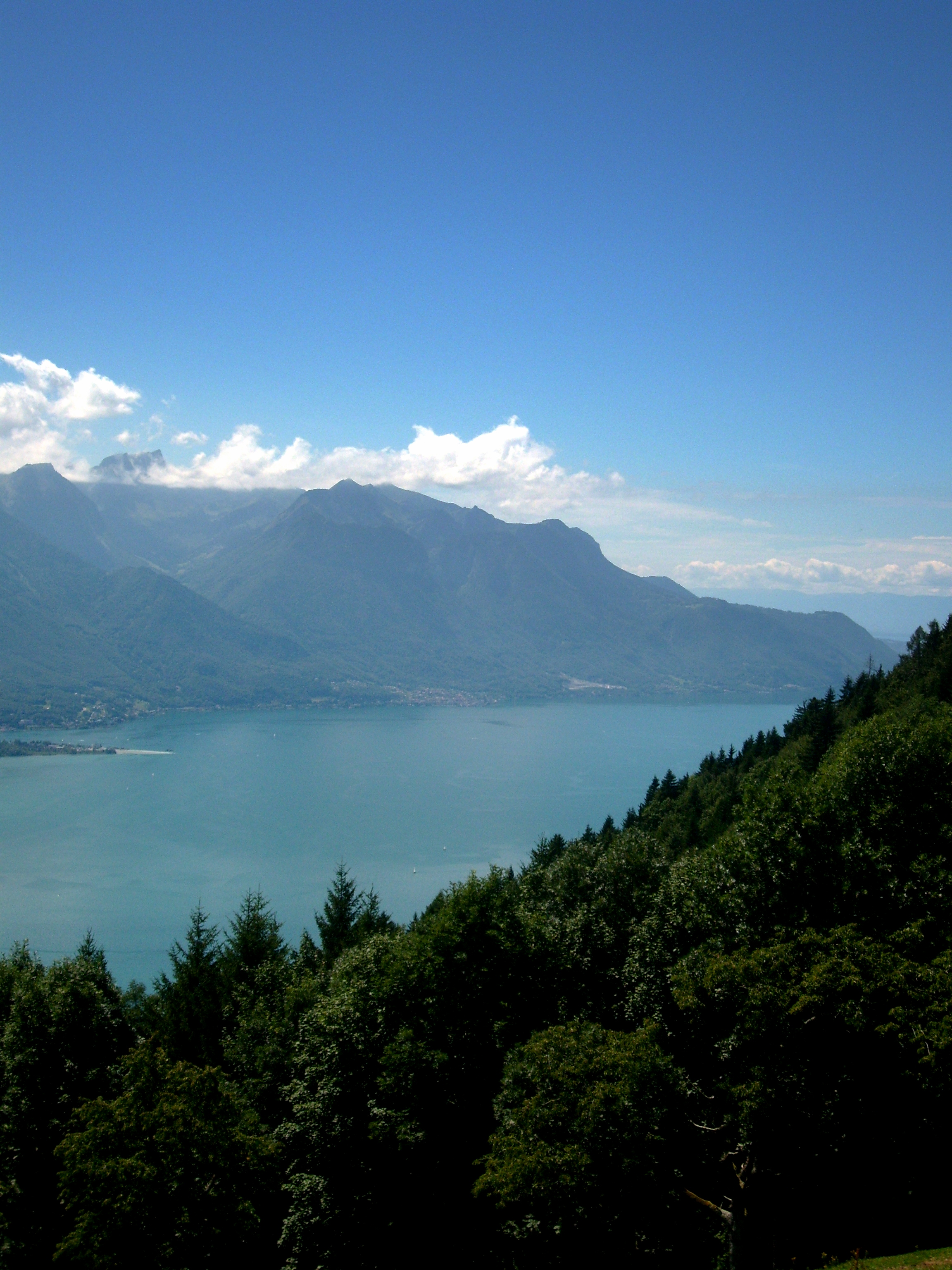
Lake Geneva is the largest body of water in Switzerland, and greatly exceeds in size all others that are connected with the main valleys of the Alps. It is in the shape of a crescent, with the horns pointing south, the northern shore being 95 km (59 mi), the southern shore 72 km (45 mi) in length. The crescent form was more regular in a recent geological period, when the lake extended to Bex, about 18 km (11 mi) south of Villeneuve. The detritus of the Rhône has filled up this portion of the bed of the lake, and it appears that within the historical period the waters extended about 2 km (1.2 mi) beyond the present eastern margin of the lake. The greatest depth of the lake, in the broad portion between Évian-les-Bains and Lausanne, where it is just 13 km (8.1 mi) in width, has been measured as 310 m (1,020 ft), putting the bottom of the lake at 62 m (203 ft) above sea level. The lake's surface is the lowest point of the cantons of Valais and Vaud.[10] The culminating point of the lake's drainage basin is Monte Rosa at 4,634 metres above sea level.[11]

The beauty of the shores of the lake and of the sites of many of the places near its banks has long been celebrated. However, it is only from the eastern end of the lake, between Vevey and Villeneuve, that the scenery assumes an Alpine character. On the south side the mountains of Savoy and Valais are for the most part rugged and sombre, while those of the northern shore fall in gentle vine-covered slopes, thickly set with villages and castles.[10]
The snowy peaks of the Mont Blanc are shut out from the western end of the lake by the Voirons mountain, and from its eastern end by the bolder summits of the Grammont, Cornettes de Bise and Dent d'Oche, but are seen from Geneva, and between Nyon and Morges. From Vevey to Bex, where the lake originally extended, the shores are enclosed by comparatively high and bold mountains, and the vista terminates in the grand portal of the defile of St. Maurice, cleft to a depth of nearly 2,700 m (8,900 ft) between the opposite peaks of the Dents du Midi and the Dent de Morcles.[10]
The shore between Nyon and Lausanne is called La Côte because it is flatter. Between Lausanne and Vevey it is called Lavaux and is famous for its hilly vineyards.[12][13]
The average surface elevation of 372 m (1,220 ft) above sea level is controlled by the Seujet Dam in Geneva.[14]
Climate
Due to climate change, the average temperature of deep water (more than 300 metres or 980 feet deep) increased from 4.4 °C (39.9 °F) in 1963 to 5.5 °C (41.9 °F) in 2016 (an increase of 1.1 °C or 2.0 °F in 53 years), while the average temperature of surface water (five metres or 16 feet deep) increased from 10.9 °C (51.6 °F) in 1970 to 12.9 °C (55.2 °F) in 2016 (up 2 °C or 3.6 °F in 46 years).[15]
| Climate data for Genève–Cointrin (Reference period 1981–2010), Records (1901–2015) | |||||||||||||
|---|---|---|---|---|---|---|---|---|---|---|---|---|---|
| Month | Jan | Feb | Mar | Apr | May | Jun | Jul | Aug | Sep | Oct | Nov | Dec | Year |
| Record high °C (°F) | 17.3 (63.1) |
20.6 (69.1) |
24.9 (76.8) |
27.5 (81.5) |
33.8 (92.8) |
36.5 (97.7) |
39.7 (103.5) |
37.6 (99.7) |
34.8 (94.6) |
27.3 (81.1) |
23.2 (73.8) |
20.8 (69.4) |
39.7 (103.5) |
| Average high °C (°F) | 4.5 (40.1) |
6.3 (43.3) |
11.2 (52.2) |
14.9 (58.8) |
19.7 (67.5) |
23.5 (74.3) |
26.5 (79.7) |
25.8 (78.4) |
20.9 (69.6) |
15.4 (59.7) |
8.8 (47.8) |
5.3 (41.5) |
15.2 (59.4) |
| Daily mean °C (°F) | 1.5 (34.7) |
2.5 (36.5) |
6.2 (43.2) |
9.7 (49.5) |
14.2 (57.6) |
17.7 (63.9) |
20.2 (68.4) |
19.5 (67.1) |
15.4 (59.7) |
11.1 (52.0) |
5.5 (41.9) |
2.8 (37.0) |
10.5 (50.9) |
| Average low °C (°F) | −1.3 (29.7) |
−1 (30) |
1.6 (34.9) |
4.8 (40.6) |
9.1 (48.4) |
12.3 (54.1) |
14.4 (57.9) |
14.0 (57.2) |
10.8 (51.4) |
7.4 (45.3) |
2.4 (36.3) |
0.1 (32.2) |
6.2 (43.2) |
| Record low °C (°F) | −19.9 (−3.8) |
−20.0 (−4.0) |
−13.3 (8.1) |
−5.2 (22.6) |
−2.2 (28.0) |
1.3 (34.3) |
3.0 (37.4) |
4.9 (40.8) |
0.2 (32.4) |
−4.7 (23.5) |
−10.9 (12.4) |
−17.0 (1.4) |
−20.0 (−4.0) |
| Average precipitation mm (inches) | 76 (3.0) |
68 (2.7) |
70 (2.8) |
72 (2.8) |
84 (3.3) |
92 (3.6) |
79 (3.1) |
82 (3.2) |
100 (3.9) |
105 (4.1) |
88 (3.5) |
90 (3.5) |
1,005 (39.6) |
| Average snowfall cm (inches) | 10.8 (4.3) |
8.1 (3.2) |
2.8 (1.1) |
0.2 (0.1) |
0.0 (0.0) |
0.0 (0.0) |
0.0 (0.0) |
0.0 (0.0) |
0.0 (0.0) |
0.0 (0.0) |
2.8 (1.1) |
7.4 (2.9) |
32.1 (12.6) |
| Average precipitation days (≥ 1.0 mm) | 9.5 | 8.1 | 9.0 | 8.9 | 10.6 | 9.3 | 7.6 | 7.9 | 8.1 | 10.1 | 9.9 | 10.0 | 109.0 |
| Average snowy days (≥ 1.0 cm) | 2.5 | 2.0 | 0.9 | 0.1 | 0.0 | 0.0 | 0.0 | 0.0 | 0.0 | 0.0 | 0.7 | 2.0 | 8.2 |
| Average relative humidity (%) | 81 | 76 | 69 | 67 | 69 | 66 | 64 | 67 | 73 | 79 | 81 | 81 | 73 |
| Mean monthly sunshine hours | 59 | 88 | 154 | 177 | 197 | 235 | 263 | 237 | 185 | 117 | 66 | 49 | 1,828 |
| Percent possible sunshine | 23 | 33 | 45 | 46 | 45 | 53 | 58 | 58 | 53 | 38 | 26 | 20 | 44 |
| Source 1: MeteoSwiss[16] | |||||||||||||
| Source 2: KNMI[17] | |||||||||||||
| Climate data for Pully (Lausanne) (1981–2010), Extremes (1981-2010) | |||||||||||||
|---|---|---|---|---|---|---|---|---|---|---|---|---|---|
| Month | Jan | Feb | Mar | Apr | May | Jun | Jul | Aug | Sep | Oct | Nov | Dec | Year |
| Record high °C (°F) | 14.9 (58.8) |
15.8 (60.4) |
22.6 (72.7) |
25.5 (77.9) |
31.3 (88.3) |
33.6 (92.5) |
35.2 (95.4) |
37.1 (98.8) |
28.6 (83.5) |
25.4 (77.7) |
19.8 (67.6) |
17.7 (63.9) |
37.1 (98.8) |
| Average high °C (°F) | 4.4 (39.9) |
5.6 (42.1) |
10.1 (50.2) |
14.0 (57.2) |
18.7 (65.7) |
22.4 (72.3) |
25.0 (77.0) |
24.4 (75.9) |
19.8 (67.6) |
14.6 (58.3) |
8.6 (47.5) |
5.3 (41.5) |
14.4 (57.9) |
| Daily mean °C (°F) | 1.2 (34.2) |
3.0 (37.4) |
6.6 (43.9) |
10.0 (50.0) |
14.4 (57.9) |
17.8 (64.0) |
20.3 (68.5) |
19.7 (67.5) |
15.8 (60.4) |
11.6 (52.9) |
6.1 (43.0) |
3.2 (37.8) |
10.9 (51.6) |
| Average low °C (°F) | 0.3 (32.5) |
0.7 (33.3) |
3.5 (38.3) |
6.4 (43.5) |
10.7 (51.3) |
13.8 (56.8) |
16.1 (61.0) |
15.9 (60.6) |
12.6 (54.7) |
9.1 (48.4) |
4.2 (39.6) |
1.4 (34.5) |
7.9 (46.2) |
| Record low °C (°F) | −16.7 (1.9) |
−12.7 (9.1) |
−9.1 (15.6) |
−2.9 (26.8) |
2.1 (35.8) |
5.2 (41.4) |
9 (48) |
8.2 (46.8) |
4.4 (39.9) |
−1.2 (29.8) |
−6.2 (20.8) |
−10.1 (13.8) |
−16.7 (1.9) |
| Average precipitation mm (inches) | 77 (3.0) |
67 (2.6) |
78 (3.1) |
87 (3.4) |
117 (4.6) |
112 (4.4) |
92 (3.6) |
110 (4.3) |
114 (4.5) |
113 (4.4) |
93 (3.7) |
92 (3.6) |
1,153 (45.4) |
| Average snowfall cm (inches) | 10.9 (4.3) |
14.3 (5.6) |
1.6 (0.6) |
0.2 (0.1) |
0.0 (0.0) |
0.0 (0.0) |
0.0 (0.0) |
0.0 (0.0) |
0.0 (0.0) |
0.0 (0.0) |
1.1 (0.4) |
7.0 (2.8) |
35.1 (13.8) |
| Average precipitation days (≥ 1.0 mm) | 10.1 | 8.8 | 10.2 | 9.8 | 12.1 | 10.4 | 9.0 | 9.5 | 8.8 | 10.1 | 10.2 | 10.7 | 119.7 |
| Average snowy days (≥ 1.0 cm) | 2.9 | 2.8 | 1.3 | 0.1 | 0.0 | 0.0 | 0.0 | 0.0 | 0.0 | 0.0 | 0.8 | 1.9 | 9.8 |
| Average relative humidity (%) | 78 | 73 | 68 | 66 | 67 | 66 | 65 | 68 | 73 | 78 | 78 | 78 | 72 |
| Mean monthly sunshine hours | 72 | 97 | 159 | 179 | 201 | 229 | 252 | 234 | 183 | 128 | 79 | 58 | 1,872 |
| Percent possible sunshine | 29 | 37 | 46 | 47 | 48 | 54 | 59 | 58 | 52 | 42 | 32 | 26 | 46 |
| Source 1: MeteoSwiss[18] | |||||||||||||
| Source 2: StatistiqueVaud [19] | |||||||||||||
Bise
Lake Geneva (and particularly the lakeside parts of the city of Geneva) can be affected by the cold Bise, a northeasterly wind. This can lead to severe icing in winter.[20] The strength of the Bise wind can be determined by the difference in air pressure between Geneva and Güttingen in canton of Thurgau. The Bise arises when the air pressure in Güttingen is higher than in Geneva.[21]
Environment


In 563, according to the writings of Gregory of Tours and Marius Aventicensis, a tsunami wave swept along the lake, destroying the fort of Tauredunum and other settlements, and causing numerous deaths in Geneva. Simulations indicate that the Tauredunum event was most likely caused by a massive landslide near the Rhône delta, which caused a wave eight metres (26 ft) high to reach within 70 minutes.[22][23][24] In 888 the town was part of the new Kingdom of Burgundy, and, with it, was absorbed into the Holy Roman Empire in 1033.
In the late 1960s, pollution made it dangerous to swim at some beaches of the lake; indeed, visibility under water was near zero.[25][26] By the 1980s, intense environmental pollution (eutrophication) had almost wiped out all the fish. Endemic whitefish species Coregonus fera was last recorded in the lake in 1920 and now extinct. Although the name fera is still used for the only coregonid present in the lake, this is not the original species but the introduced C.palaea. Today, pollution levels have been dramatically cut back, and it is again considered safe to swim in the lake.[27][28] Major leisure activities practiced include sailing, wind surfing, boating (including water skiing and wake-boarding), rowing, scuba diving and bathing.
A total of four submarines have plied the depths of Lake Geneva.[29] In 1964, Jacques Piccard launched a tourist-oriented submarine, the Auguste Piccard (named for his explorer father), for the Swiss National Exhibition, meant to honor the Expo 64 theme of accomplishments by Swiss engineers and industry.[30] After operating through to 1965 in Lake Geneva, Piccard used the vessel for scientific exploration in other parts of the world.[30] Piccard later built the F.-A. Forel, launched in Lake Geneva in 1978 and used primarily for scientific research until it was retired in 2005.[30] In 2011, in a collaborative operation led by École Polytechnique Fédérale de Lausanne, two Mir submersibles were used for ten weeks to conduct extensive scientific research in Lake Geneva.[29]
On a scientific footnote, in 1827, Lake Geneva was the site for the first measurement of the speed of sound in (fresh) water.[31] French mathematician Jacques Charles François Sturm and Swiss physicist Daniel Collodon used two moored boats, separated by a measured distance, as the transmit and receive platforms for the sounds of exploding gunpowder. The loud airborne sound coupled into the lake, establishing a loud underwater sound that could be measured at a distance. The flash of the exploding gunpowder provided the visual starting cue for the timepiece, and the underwater explosion sound striking a bell provided the finish cue.
The lake is rich in wildlife, especially birds: both the common buzzard and the red kite breed here in considerable numbers.
Sport events
Yacht racing is a popular sport, and high-performance catamarans have been developed specifically for the lake.[32] The design of the Alinghi 5, the defender of the 2010 America's Cup, was influenced by those racing catamarans.[32] The best-known event, the Bol d'Or (not to be confused with other events having the same name) runs from Geneva to the end of the lake and back.[33]
The Tour du Lac rowing event also takes place on Lake Geneva. Competitors row once around the entire lake, making this 160-kilometre (99 mi) event the longest non-stop rowing regatta in the world.
Several competitions for swimmers are organised yearly like the crossing of the lake from Lausanne to Evian (13km),[34] from Chillon Castle to Geneva (70km), [35] from Montreux to Clarens (1.8 km),[36] in Geneva (1.8 km),[37] all in summer, and the Coupe de Noël, 125m in Geneva in December.[38]
Towns and villages
| Southern shore | Northern shore | |
|---|---|---|
| Haut Lac |
Canton of Valais (VS):
Haute-Savoie: |
Canton of Vaud (VD):
|
| Grand Lac |
Haute-Savoie:
|
VD:
|
| Petit Lac |
Haute-Savoie: Canton of Geneva (GE):
|
VD:
GE:
|
Topographic map


Notable residents
Edmund Ludlow, famous as one who had signed the death warrant of English King Charles I, was granted on 16 April 1662 protection in and continued to live at Vevey until his death in 1692.[39] Mary and Percy Shelley and Lord Byron holidayed by the lake and wrote ghost stories, one of which became the basis for the novel Frankenstein.[40] The Empress Elisabeth of Austria (Sisi) was stabbed to death on the quayside in Geneva in September 1898. Vladimir Lenin rented a little "chalet" at the French bank, near Geneva.[41] Actor Charlie Chaplin spent his final years and died in Vevey (there is a memorial statue of him along the promenade; his home at Corsier-sur-Vevey is now a museum of his life and career). Actors Noël Coward, James Mason, Sir Peter Ustinov, Richard Burton and Audrey Hepburn all lived in villages on the shores of or in view of the lake. David Bowie moved to a chalet to the north of Lake Geneva in 1976, which inspired him to take up painting and informed the first stages of the "Berlin Trilogy". Pop singer Phil Collins lives in a home overlooking the lake.[42] Rock band Queen owned and operated Mountain Recording Studios (which is still in use today) in Montreux, and a statue of lead singer Freddie Mercury, who also owned a second home in Montreux, stands on the northern shore of the lake. Writer Vladimir Nabokov also took residence in Montreux, where he died in 1977. Ex-Formula 1 driver Michael Schumacher lives with his family in a home overlooking the lake.
See also
- Lake Geneva region
References
- "Les Grangettes". Ramsar Sites Information Service. Retrieved 25 April 2018.
- "Rives du Lac Léman". Ramsar Sites Information Service. Retrieved 25 April 2018.
- "03 - Suisse sud-ouest". Swiss National Map 1:200 000 - Switzerland on four sheets. Federal Office of Topography, swisstopo, Swiss Federal Department of Defence, Civil Protection and Sport. 2009. Archived from the original on 11 April 2014. Retrieved 12 November 2013.
- Italian: Lago Lemano; rarely lac de Genève [lak də ʒ(ə)nɛv]; Romansh: Lai da Genevra)
- "What you call Lake Geneva really does matter, according to a poll". Le News. 28 November 2016. Retrieved 28 October 2020.
- Orell, Fussli et compagnie, ed. (1820). Voyage pittoresque au lac de Genève ou Léman (in French). Retrieved 28 July 2019.
- "Le Léman". map.geo.admin.ch. Swisstopo. Retrieved 13 October 2021.
- "Le Léman". Géoportail (in French). Institut national de l'information géographique et forestière. Retrieved 13 October 2021.
- "270 - Genève". Swiss National Map 1:50 000 - Switzerland on 78 maps. Federal Office of Topography, swisstopo, Swiss Federal Department of Defence, Civil Protection and Sport. 2011. Archived from the original on 12 November 2013. Retrieved 12 November 2013.
- John Ball, A Guide to the Western Alps, p. 254
- 1:25,000 topographic map (Map). Swisstopo. Retrieved 27 July 2014.
- Cuckoo, Paul (26 October 2007). "Switzerland mastering the art of wine making". The Economic Times. India Times. Retrieved 24 June 2009.
- Mourby, Adrian (19 August 2007). "European Breaks: Three suns, one grape, a lot of flavour". The Independent. Retrieved 24 June 2009.
- Seujet / Lac Léman Archived 7 July 2011 at the Wayback Machine rhone-geneve.ch. Retrieved on 20 July 2009
- La lettre du Léman, bulletin of the Commission internationale pour la protection des eaux du Léman, number 54, June 2017, page 3.
- "Climate normals Genève–Cointrin (Reference period 1981–2010)" (PDF). Zürich-Airport, Switzerland: Swiss Federal Office of Metreology and Climatology, MeteoSwiss. 2 July 2014. Retrieved 5 April 2015.
- "Genève–Cointrin extreme values". KNMI. Retrieved 8 November 2011.
- "Climate normals Pully (Reference period 1981−2010)" (PDF). Zurich Airport, Switzerland: Swiss Federal Office of Metreology and Climatology, MeteoSwiss. 2 July 2014. Retrieved 3 April 2015.
- (in French) http://www.scris.vd.ch/Default.aspx?DocID=8033&DomId=1961.
- "La bise va se calmer après une journée chaotique, mais plusieurs écoles vont rester fermées" (in French). Geneva: RTS Radio Télévision Suisse. 17 January 2017. Retrieved 25 February 2018.
- "Bisendiagramm". Appenzell, Switzerland: MeteoGroup Schweiz AG. Retrieved 25 February 2018.
- Kremer, K.; Simpson, G.; Girardclos, S. P. (2012). "Giant Lake Geneva tsunami in AD 563". Nature Geoscience. 5 (11): 756–757. Bibcode:2012NatGe...5..756K. doi:10.1038/ngeo1618.
- "Tsunamis on Lake Geneva: Lake monsters". The Economist. 28 October 2012. Retrieved 29 October 2012.
- Marshall, Jessica (28 October 2012). "Ancient tsunami devastated Lake Geneva shoreline". Nature. doi:10.1038/nature.2012.11670. S2CID 130238584. Retrieved 5 November 2012.
- "Convention concerning protection of the waters of Lake Geneva against pollution" (PDF). United Nations Treaty Collection. 16 November 1962. Retrieved 24 June 2009.
- Bergier, Jean-François (2008). Dictionnaire historique de la Suisse. Dictionnaire historique de la Suisse (in French). Vol. 7. Editions Gilles Attinger, Hauterive. ISBN 978-2-88256-197-8.
- "Baisse du Phosphore dans le Léman" (PDF) (in French). Commission Internationale pour la Protection du Léman (CIPEL). 9 May 2007. Archived from the original (PDF) on 5 January 2009. Retrieved 26 June 2009.
- Monna, F.; Domnik J.; Loiseau J.-L.; Pardos M.; Arpagaus P. (1999). "Origin and evolution of Pb in sediments of Lake Geneva (Switzerland-France). Establishing a stable Pb record". Environmental Science & Technology. Washington, DC: American Chemical Society. 33 (17): 2850–2857. Bibcode:1999EnST...33.2850M. doi:10.1021/es9902468. ISSN 0013-936X.
- Dubuis, Etienne (10 June 2011). "A la découverte du Léman". Le Temps (in French). Retrieved 1 November 2014.
- Dubuis, Etienne (10 June 2011). "Ces submersibles qui ont plongé dans le Léman". Le Temps (in French). Retrieved 18 April 2019.
- Guichonnet, Paul (2002). Nature et histoire du Léman: le guide du Léman (in French). Divonne-Les-Bains: Editions Cabedita. p. 235. ISBN 9782882951205.
- "alinghi.com". Archived from the original on 8 February 2010.
- "boldor.ch". Archived from the original on 16 June 2012.
- "13 km à la nage sur le Léman, entre Lausanne et Evian !". rcf.fr.
- "LGSA Signature swim". www.lakegenevaswimmingassociation.com.
- "Commune de Montreux - Traversée à la nage Montreux-Clarens". www.montreux.ch.
- Mertenat, Thierry (31 July 2016). "La traversée du lac à la nage réussit sa première édition". TDG – via www.tdg.ch.
- "Près de 2500 courageux à la Coupe de Noël". Tribune de Genève. 15 December 2019.
- Macaulay, History of England, Vol 1, Page 400, J H Dent 1953.
- Sunstein, Emily W. (1989). Mary Shelley: Romance and Reality (1991 ed.). Baltimore: Johns Hopkins University Press. pp. 478. ISBN 0-8018-4218-2.
- "The summit: The Russians make their entrance". The NY Times. 19 November 1985. Retrieved 30 May 2011.
- Michner, Joerg (25 February 2007). "Fed-up Swiss taxpayers call time on concessions for wealthy foreigners". Telegraph.co.uk. Archived from the original on 12 January 2022. Retrieved 24 June 2009.
External links
- Lake Geneva Region
- International Commission for the Protection of Lake Geneva (CIPEL)
- Coolidge, William Augustus Brevoort (1911). . Encyclopædia Britannica. Vol. 11 (11th ed.). p. 593.
- Lake Geneva in German, French and Italian in the online Historical Dictionary of Switzerland.
Lakes of Switzerland | ||
|---|---|---|
| Major lakes |
|  |
| Lists | ||
Authority control | |
|---|---|
| General |
|
| National libraries | |
| Other |
|
На других языках
[de] Genfersee
Der Genfersee (französisch Lac Léman, Schweizer Französisch Le Léman,[3] international auch Lac de Genève, alternative Schreibweise in Deutschland und Österreich Genfer See) ist der grösste See sowohl Frankreichs als auch der Schweiz. Er liegt an der Grenze zwischen der Westschweiz und der französischen Region Auvergne-Rhône-Alpes. Die Südwestspitze des Sees gehört zum Schweizer Kanton Genf, das Nordufer zum Schweizer Kanton Waadt und das Südufer grösstenteils zum französischen Département Haute-Savoie. Daneben hat der Kanton Wallis einen kleinen Anteil am östlichen Südufer. Der See wird in Haut Lac, Grand Lac und Petit Lac eingeteilt. Nur das südlichste Ende innerhalb des Kantons Genf, etwa südwestlich der Linie Versoix–Hermance, heisst offiziell Lac de Genève.[4]- [en] Lake Geneva
[es] Lago Lemán
El lago de Ginebra, también conocido en español como lago Lemán (en francés: Lac Léman o Lac de Genève), es el mayor lago de la Europa Occidental. Se encuentra situado al norte de los Alpes, entre Francia (orilla sur) y Suiza (orilla norte incluidos los extremos occidental y oriental).[fr] Léman
Le Léman (/le.mɑ̃/ .mw-parser-output .prononciation>a{background:url("//upload.wikimedia.org/wikipedia/commons/thumb/8/8a/Loudspeaker.svg/11px-Loudspeaker.svg.png")center left no-repeat;padding-left:15px;font-size:smaller}Écoutez), ou par tautologie lac Léman, également dénommé lac de Genève notamment dans le canton de Genève et dans plusieurs langues étrangères, est un lac d'origine glaciaire situé en Suisse et en France ; par sa superficie, c'est le plus grand lac alpin et subalpin d'Europe.[it] Lago Lemano
Il lago Lemàno (in francese lac Léman, in francoprovenzale lèc Lèman), spesso chiamato lago di Ginevra, è il maggiore lago della Svizzera e dell'Europa occidentale, posto sul confine franco-svizzero ed esteso per il 40% in Francia (dipartimento dell'Alta Savoia) e per il restante 60% in Svizzera.[ru] Женевское озеро
Женевское озеро или Леман (фр. Lac Léman, Le Léman, Lac de Genève) — самое большое озеро Альп и второе по величине (вслед за Балатоном) озеро Центральной Европы[1]. Расположено в границах Швейцарии и Франции. Площадь поверхности — 582 км²[2]. Высота над уровнем моря — 372 м.[3]Другой контент может иметь иную лицензию. Перед использованием материалов сайта WikiSort.org внимательно изучите правила лицензирования конкретных элементов наполнения сайта.
WikiSort.org - проект по пересортировке и дополнению контента Википедии